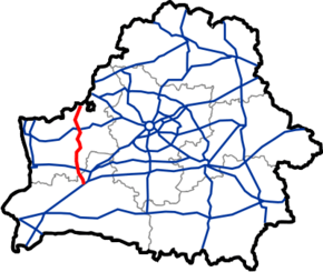
M11 highway (Belarus)
| |
|---|---|
| Магістраль М11 | |
 | |
| Route information | |
|
Part of | |
| Length | 191 km (119 mi) |
| Major junctions | |
| North end | Border of Lithuania |
| South end | Intersection with P2 |
| Location | |
| Major cities | Lida, Slonim |
| Highway system | |
| Roads in Belarus | |

М11 highway is a part of European Route ![]()
![]()
![]()
| Distance (approx.) |
Name | Other roads | |
|---|---|---|---|
| 0 km | Benyakoni border crossing | ||
| 11 km | Voranava | ||
| 18 km | Voranava | ||
| 24 km | Р135 | ||
| 40 km | Lida | ||
| 49 km | Lida | P89 | |
| 56 km | Lida | ||
| 59 km | |||
| 67 km | |||
| 81 km | P141 | ||
| 104 km | Dyatlovo | ||
| 116 km | P142 | ||
| 125 km | Kazlowshchyna | ||
| 152 km | Slonim | P41 P85 P99 | |
| 158 km | Slonim | P99 | |
| 191 km | |||
This article is issued from
Wikipedia.
The text is licensed under Creative Commons - Attribution - Sharealike.
Additional terms may apply for the media files.