Lyndhurst, New South Wales
| Lyndhurst New South Wales | |
|---|---|
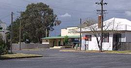 Lyndhurst with Royal Hotel in the background | |
|
Lyndhurst | |
| Coordinates | 33°40′S 149°02′E / 33.667°S 149.033°ECoordinates: 33°40′S 149°02′E / 33.667°S 149.033°E |
| Population | 219 (2011 census)[1] |
| Postcode(s) | 2797 |
| Location | |
| LGA(s) | Blayney Shire |
| State electorate(s) | Bathurst |
| Federal Division(s) | Calare |
Lyndhurst is a small village in New South Wales, Australia in Blayney Shire. It is 4 kilometres west of Mandurama or about 269 km west of Sydney and 63 km south-west of Bathurst just off the Mid-Western Highway New South Wales. Once serving as the major centre for basic goods and needs to the nearby Junction Reefs goldfields. At the 2011 census, Lyndhurst had a population of 219 people.[1]
Lyndhurst is in fact most significant for being one of the ten areas (including Albury, Armidale, Bombala, Dalgety, Lake George, Orange, Tooma, Tumut and Yass shortlisted in 1908 as a site for the Australian Capital Territory.[2]
Lyndhurst today
Lyndhurst today boasts the still functioning Royal Hotel, and a combined service station, and general store. It also has a local public school.
Heritage listings
Lyndhurst has a number of heritage-listed sites, including:
- Belubula River: Junction Reefs Dam[3]
References
- 1 2 Australian Bureau of Statistics (31 October 2012). "Lyndhurst (L) (Urban Centre/Locality)". 2011 Census QuickStats. Retrieved 3 April 2015.

- ↑ BBC Canberra, Australian Capital Territory, Australia UPDATE
- ↑ "Junction Reefs Dam, Land in the vicinity of, New South Wales State Heritage Register (NSW SHR) Number H00702". New South Wales State Heritage Register. Office of Environment and Heritage. Retrieved 18 May 2018.
External links
![]()