Lutetia
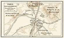 Maps of Paris (Paris sous les Romains) from Histoire et Geographie: Atlas General by Paul Vidal de La Blache | |
 Location within France | |
| Location | Paris, France |
|---|---|
| Coordinates | 48°51′N 2°21′E / 48.85°N 2.35°ECoordinates: 48°51′N 2°21′E / 48.85°N 2.35°E |
| Type | Roman city |
| History | |
| Periods | Roman Republic to Roman Empire |
The Roman city of Lutetia (also Lutetia Parisiorum in Latin, in French Lutèce) was the predecessor of present-day Paris.
Impressive monumental remains of the ancient city can still be seen in situ.
Etymology
The city was referred to as "Λουκοτοκία" by Strabo, "Λευκοτεκία" by Ptolemy and "Lutetia" by Julius Caesar. The origin of this name is uncertain.
The name may contain the Celtic root *luco-t-, which means "mouse" and -ek(t)ia, meaning "the mice" and which can be found today in the Breton word logod, the Welsh llygod, and the Irish luch.[1]
Alternatively, it may derive from another Celtic root, luto- or luteuo-, which means "marsh" or "swamp" and which survives today in the Gaelic loth ("marsh") and the Breton loudour ("dirty").[2] As such, it would be related to other place names in Europe including Lutudarum (Derbyshire, England); Lodève (Luteua) and Ludesse (France); Lutitia (Germany); Lutsk (Ukraine); Pryluky (Ukraine) and Velikiye Luki (Russia).
Gallic origins
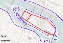
Traditionally, it was long believed that the original Gallic settlement was on the Île de la Cité but no evidence for such a settlement was found.[3]. Then archaeological excavations between 1994 and 2005 appeared to indicate that the location of Gallic Leucotekia lay in Nanterre, a large area of proto-urbanisation of several main streets and hundreds of house over 15 hectares in the suburbs of Paris, not far from the future location of Lutetia.[4] However, more recent (2013) excavations on the Île de la Cité have finally revealed a substantial Gallic settlement on the island. Arguments may now be made for either site as the original one for the city.
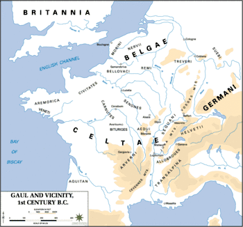
In 52 BC, a year or so before the end of Julius Caesar's Gallic Wars, the Battle of Lutetia was fought with the local Parisii tribe.[5] However the garrison led by Vercingetorix's lieutenant Camulogenus, whose army camped on Mons Lutetius, fell to the Roman military forces led by Titus Labienus, one of Caesar's generals who captured and burned the stronghold. The Romans also crushed the Gauls at nearby Melun and took control of Lutece.
Roman Lutetia
The Roman city[6] was centred on the hill on the south bank of the river (the Montagne Sainte-Geneviève), as the low-lying plain near the river was easily flooded[7] though still initially suitable for farming.[6]
The regular Roman street plan of Lutetia was established with the north-south axis, possibly dictated by the need to cross the marshy riverbanks in the shortest possible distance, but also aligning with the standard Roman orientation for a cardo maximus. Two main routes converged at the bridgehead over the Seine: one road coming from Spain (today's rue St-Jacques) via Orleans was used as the main axis (cardo maximus), and the other road from Rome (today's rue Galande and further on rue Mouffetard) via Lyon. Dendrochronological study of wooden pilings beneath the lowest stratum of the Roman north-south axis date the road's construction after 4 AD, more than fifty years after the Roman pacification of the region. On the north bank the Rue St-Martin continues the Roman main axis (cardo maximus).
The street plan and the boundaries of the main monuments—the forum at the top of the hill, theatre, baths— show that the Roman city was laid out with blocks or insulae of 300 Roman feet.
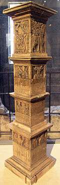
The development of the city began under Augustus and was well advanced in the early 1st century AD when the elaborate Pilier des Nautes (pillar of the boatmen) was erected by a corporation of local river merchants and sailors (nautes) and dedicated to Tiberius and to several gods, showing that there was an important port on the river.
Major public works and monuments were constructed in the 2nd century AD.[8] Lutetia expanded with a population estimated at around 8,000 but did not have a great deal of political importance - the capital of its province, Lugdunensis Senona, was Agedincum (modern Sens, Yonne).
An aqueduct 26 km in length, with a flow rate estimated at 2000 cubic metres a day, provided the city with spring water collected from several points. To bridge the Bièvre valley at Arcueil-Cachan, a bridge was required, whose piers and ruined arches, still discernible, gave rise to the toponym Arcueil.
In the 3rd century St Denis became the city's first bishop and in about 250 AD he and two companions were arrested and decapitated on the hill of Mons Mercurius thereafter known as Mons Martyrum (Martyrs' Hill, or Montmartre) where Roman foundations have been found.
After a barbarian attack in 275 by the Franks and Alemanni that destroyed much of the south bank portions of the city, the population moved to the island and a surrounding wall was built on the Île de la Cité from large stones taken from damaged structures.[7] The city on the south bank along with the main public buildings including baths, the theatres and the amphitheatre were gradually abandoned.
In 357-8 Julian II, as Caesar of the Western empire and general of the Gallic legions, moved the Roman capital of Gaul from Trier to Paris which, after defeating the Franks in a major battle at Strasbourg in 357, he defended against Germanic invaders coming from the north. He was proclaimed emperor by his troops in 360 in Lutetia.
Later Valentinian I resided in Lutetia for a brief period (365-366).[9]
Lutetia was gradually renamed Paris,[10] taking its name from the Parisii. The name had already been used for centuries as an adjective ("Parisiacus"). The legend of the Breton city of Ys suggests a different, if less likely, origin.
Remains
Remains of the ancient city are mainly buried below ground although many of these are gradually being discovered. Those visible include:
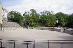
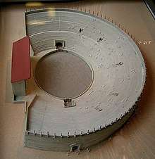
- the amphitheatre, Arènes de Lutèce in a small park on high ground in the Latin Quarter of the Left Bank, tucked behind apartment blocks. 1st-century AD, built into the slope of the hillside outside the Roman city, it was one of the largest such structures in Gaul.
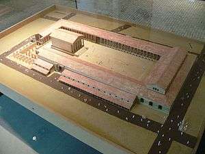
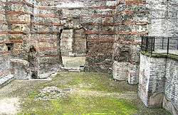
- Public thermal baths, Thermes de Cluny. Now the Musée de Cluny, the existing building is only a part of the original covering several hectares that stretched from boulevard Saint-Germain to rue des Ecoles and Boulevard Saint-Michel. Built at the end of the 1st/beginning of the 2nd c. AD at the corner of the cardo and decumanus. First probable destruction during the invasion by the Franks and Alamans in 275. The frigidarium, with intact vault, and the caldarium are the main remaining rooms which were originally clad internally with mosaic, marble or paintings. The northern side was occupied by two gymnasia and the centre of the facade on this side was occupied by a monumental fountain. Underground is a set of cellars and vaulted galleries where the drain for emptying the frigidarium pool is visible.[11] Water flowed out through a drain that encircled the baths and ran into a main drain located under boulevard Saint-Michel.
- The Archaeological Crypt under the Notre Dame forecourt including a section of the quay wall of the ancient port, a public bath with hypocaust heating, part of the city wall from beginning of the 4th c.
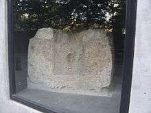
- Wall of the forum
Many artifacts from Lutetia have been recovered and are on display at the Musée Carnavalet.
May 2006 findings
In May 2006, a Roman road was found during expansion of the University of Pierre and Marie Curie campus. Remains of private houses dating from the reign of Augustus (27 BC-14 AD) and containing heated floors were found. Everyday items like flowerpots, bronze chains, ceramics, and drawer handles were found. The owners were wealthy enough to own baths found in one of the homes, a status symbol among Roman citizens.
Legacy
Several scientific discoveries have been named after Lutetia. The element lutetium was named in honor of its discovery in a Paris laboratory, and the characteristic building material of the city of Paris — Lutetian Limestone — derives from the ancient name. The "Lutetian" is, in the geologic timescale, a stage or age in the Eocene Epoch. The asteroid 21 Lutetia, discovered in 1852 by Hermann Goldschmidt, is named after the city.
Lutetia is featured in the French comic series The Adventures of Asterix.
References
- ↑ La langue gauloise, Pierre-Yves Lambert, éditions errance 1994.
- ↑ Dictionnaire de la langue gauloise, Xavier Delamarre, éditions errance 2003.
- ↑ Jim Chevallier, A History of the Food of Paris: From Roast Mammoth to Steak Frites, 2018, ISBN 1442272821, p. 11
- ↑ Nanterre et les Parisii : Une capitale au temps des Gaulois ?, Antide Viand, ISBN 978-2757201626
- ↑ Julius Caesar: De Bello Gallico, VII 62
- 1 2 "Paris, a Roman city". www.paris.culture.fr.
- 1 2 Fleury, M., "Lutetia Parisiorum", The Princeton encyclopedia of classical sites, (Richard Stillwell, William L.MacDonald, and Marian Holland McAlister,eds.) Princeton, N.J. Princeton University Press. 1976
- ↑ 2 Roman and Medieval Paris, Clifton Ellis, PhD Architectural History, Texas Tech College of Architecture - TTU College of Architecture
- ↑ Goudineau, Christian, "Lutetia" in Dictionary of Antiquity under the direction of Jean Leclant. PUF. 2005
- ↑ The City of Antiquity Archived 2008-12-12 at the Wayback Machine., official history of Paris by The Paris Convention and Visitors Bureau
- ↑ Alain Bouet and Florence Saragoza, "Les Thermes de Cluny", the Archeologia files, no. 323, p. 25
- ↑ "Roman aqueducts: Paris (country)". www.romanaqueducts.info.
Further reading
- Philippe de Carbonnières, Lutèce: Paris ville romaine (Gallimard 20012, ISBN 2-07-053389-1)
External links
| Wikimedia Commons has media related to Lutetia. |