Lubniewice
| Lubniewice | ||
|---|---|---|
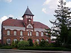 Town Hall | ||
| ||
 Lubniewice | ||
| Coordinates: 52°30′59″N 15°14′59″E / 52.51639°N 15.24972°E | ||
| Country |
| |
| Voivodeship | Lubusz | |
| County | Sulęcin | |
| Gmina | Lubniewice | |
| Area | ||
| • Total | 12.11 km2 (4.68 sq mi) | |
| Population (2006) | ||
| • Total | 1,929 | |
| • Density | 160/km2 (410/sq mi) | |
| Postal code | 69-210 | |
| Website | http://www.lubniewice.pl | |
Lubniewice [lubɲɛˈvʲit͡sɛ] (German: Königswalde) is a small town in Sulęcin County, Lubusz Voivodeship, western Poland, with 1,924 inhabitants (2004). It is the administrative seat of Gmina Lubniewice.
History

The first mentioning of a fortress dates back to the Greater Polish duke Przemysł II in 1287. A 1322 deed referred to a nearby settlement of German colonists named Königswalde, established in the course of the Ostsiedlung in the Neumark region at the behest of the Brandenburgian margraves. It was located close to the Imperial border with the Poznań Voivodeship of the Polish Crown in the east. In 1352 the Wittelsbach elector Louis II of Brandenburg enfeoffed his ministeriales of the Waldow noble family with the Königswalde estates.
From the late 17th century onwards the population increased by the immigration of Polish Brethren and Protestants from Silesia. In 1706 Samuel Crellius became minister at the parish church. Königswalde received town privileges in 1808 and was incorporated into the Prussian Province of Brandenburg in 1815. After World War II and the implementation of the Oder-Neisse line, Lubniewice fell to the Republic of Poland and the German population was expelled.
Notable people
- Eduard Petzold (1815–1891), landscape gardener.
| Wikimedia Commons has media related to Lubniewice. |
| Town and seat |  | |
|---|---|---|
| Villages | ||