Lorentzweiler
| Lorentzweiler Luerenzweiler | ||
|---|---|---|
| Commune | ||
 | ||
| ||
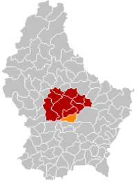 Map of Luxembourg with Lorentzweiler highlighted in orange, and the canton in dark red | ||
| Coordinates: 49°42′N 6°09′E / 49.7°N 6.15°ECoordinates: 49°42′N 6°09′E / 49.7°N 6.15°E | ||
| Country |
| |
| Canton | Mersch | |
| Government | ||
| • Mayor | Jos Roller | |
| Area | ||
| • Total | 17.45 km2 (6.74 sq mi) | |
| Area rank | 67 of 102 | |
| Highest elevation | 436 m (1,430 ft) | |
| • Rank | 25th of 102 | |
| Lowest elevation | 219 m (719 ft) | |
| • Rank | 36th of 102 | |
| Population (2014) | ||
| • Total | 3,673 | |
| • Rank | 39th of 102 | |
| • Density | 210/km2 (550/sq mi) | |
| • Density rank | 33rd of 102 | |
| Time zone | UTC+1 (CET) | |
| • Summer (DST) | UTC+2 (CEST) | |
| LAU 2 | LU00012008 | |
| Website | lorentzweiler.lu | |

Lorentzweiler (Luxembourgish: Luerenzweiler) is a commune and small town in central Luxembourg, in the canton of Mersch. It is situated on the river Alzette.
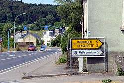
As of 2005, the town of Lorentzweiler, which lies in the centre of the commune, has a population of 743. Other towns within the commune include Blaschette, Bofferdange, and Helmdange, Hunsdorf.
External links

Places adjacent to Lorentzweiler | |
|---|---|
|  | |
This article is issued from
Wikipedia.
The text is licensed under Creative Commons - Attribution - Sharealike.
Additional terms may apply for the media files.