Long Island (Southland)
 Long Island Location in New Zealand | |
| Geography | |
|---|---|
| Location | Fiordland |
| Coordinates | 45°46′S 166°42′E / 45.767°S 166.700°ECoordinates: 45°46′S 166°42′E / 45.767°S 166.700°E |
| Area | 18.99 km2 (7.33 sq mi) |
| Length | 12 km (7.5 mi) |
| Width | 2 km (1.2 mi) |
| Highest elevation | 620 m (2,030 ft) |
| Administration | |
| Demographics | |
| Population | 0 |
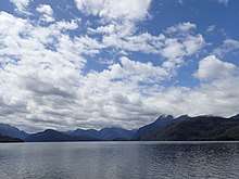
Cooper Island (High & Left of Center) & Long Island (RHS)
Long Island is an island in Fiordland, in the southwest of New Zealand's South Island. It lies within Dusky Sound, to the southeast of Resolution Island, and is separated from it and the South island mainland by Bowen Channel to the north, and from the South Island mainland by Cook Channel to the south.
Long Island is almost 19 square kilometres (7.3 sq mi) in size, but distinctively narrow at 12 kilometres (7.5 mi) in length and a maximum of 2 kilometres (1.2 mi) in width.[1] The island is part of Fiordland National Park and is the fourth-largest island in the park with no possums present.[2]
References
- ↑ "Tamatea/Dusky Sound convervation and restoration plan" (PDF). Department of Conservation. p. 21. Retrieved 2017-10-17.
- ↑ "Project implementation: Fiordland Island restoration programme". Department of Conservation. Retrieved 2017-10-13.
- Reed New Zealand Atlas(2004). Auckland: Reed Books. Map 104
This article is issued from
Wikipedia.
The text is licensed under Creative Commons - Attribution - Sharealike.
Additional terms may apply for the media files.