Lomnický štít
| Lomnický štít | |
|---|---|
 Lomnický štít (left) and Kežmarský štít (2558 m) | |
| Highest point | |
| Elevation | 2,634.4 m (8,643 ft) |
| Prominence | 434 m (1,424 ft) |
| Coordinates | 49°11′45″N 20°12′46″E / 49.19583°N 20.21278°ECoordinates: 49°11′45″N 20°12′46″E / 49.19583°N 20.21278°E |
| Naming | |
| Nickname | Lomničák |
| Geography | |
 Lomnický štít Location in Slovakia | |
| Location | Tatra National Park, Poprad, Prešov, Slovakia |
| Parent range | High Tatras |
| Climbing | |
| First ascent | Štefan Fábry, around 1760-1790 |
| Easiest route | cable car |
Lomnický štít (English: Lomnica Peak[1][2] or Lomnický Peak[3][4] Hungarian: Lomnici-csúcs) is one of the highest and most visited mountain peaks in the High Tatras mountains of Slovakia. Connected by cable car to Tatranská Lomnica, its summit is 2634 metres above sea level, making it the second highest peak in the High Tatras after Gerlachovský štít (2654 m).
Local shoemaker and amateur miner Jakab Fábry stated he made an ascent around 1760-1790, but the first recorded ascent was made by the English traveler Robert Townson and guide on 16 August 1793. He measured almost precisely the elevation of the peak at 2633 m. The first winter ascent was made in 1891.
In the past, Lomnický štít was called as Vater (Father), Grossvater (Grandfather), Königsberg (King's Mountain), Królowa Tatr and Królowa Tatrzańska (Princess of the Tatra), Petra altissima kesmarkiensis and allerhöchster Kaisermärkerfels (Highest cliff of Kežmarok), höchste Kaisermärker Spitze (Highest peak of Kežmarok), késmárki hegyek (Hills of Kežmarok), Kesmarker Spitze or Lumnitzer Spitze (Peak of Kežmarok or Peak of Lomnica). Before the 19th century, the peak was also thought to be the highest of all.
Since 1940, tourists have reached the peak by cable car, which was the most modern in Europe at the time of opening. They are allowed to stay on the peak for 50 minutes. The cable car system is normally closed in the month of May for annual maintenance. It is also possible to climb the peak from Lomnický Saddle, but this is only permitted with a mountain guide.
There is a solar observatory and weather station permanently manned year round at the terminus of the cable car.
Gallery
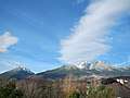 Slavkovský štít (left) and Lomnický štít (center right) as seen from Tatranská Lomnica, Slovakia
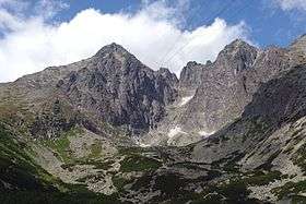
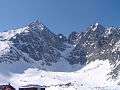 From left: Lomnický štít, Vidlové veže, Kežmarský štít, and Malý Kežmarský štít, as viewed from Skalnaté pleso
 Solar observatory Lomnický štít (Slovakia) built in 1962
 The observatory as seen from Tatranská Lomnica
References
- ↑ Nározná, Renáta, & Colin Saunders. 2012. The High Tatras: Slovakia and Poland, Including the Western & White Tatras. Milnthorpe, UK: Cicerone, p. 156.
- ↑ Cohen, Saul Bernard. 2008. The Columbia Gazetteer of the World: P to Z. New York: Columbia University Press, p. 3822.
- ↑ Brooks, Andrew. 2016. Children's Illustrated Atlas. London: Dorling Kindersley, p. 69.
- ↑ Lovejoy, Alice Osborne. 2014. Army Film and the Avant Garde: Cinema and Experiment in the Czechoslovak Military. Bloomington: Indiana University Press, p. 223.
Sources
External links
| Wikimedia Commons has media related to High Tatra Mountains. |