Manaro Voui
| Manaro Voui | |
|---|---|
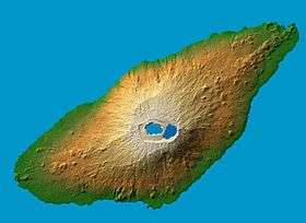 False color (elevation) and computed shadows map of Manaro Voui
| |
| Highest point | |
| Elevation | 1,496 m (4,908 ft) |
| Prominence | 1,496 metres (4,908 ft) |
| Coordinates | 15°23′24.21″S 167°49′49.63″E / 15.3900583°S 167.8304528°ECoordinates: 15°23′24.21″S 167°49′49.63″E / 15.3900583°S 167.8304528°E |
| Geography | |
| Location | Ambae Island, Vanuatu |
| Geology | |
| Mountain type | Shield volcano |
| Last eruption | 2017–18 |
Manaro Voui[1] is a shield volcano whose emergent portion is known as the island of Ambae in Vanuatu. The summit is 1,496 metres (4,908 ft) above sea level and about 3,900 m (12,800 ft) above the sea floor.[2] According to indigenous custom Chief Virenaliu Paul Vuhu, the summit's valley and lakes are considered `the "sacred place and paradise" where they believe after death, their spirits go to live happily ever after'.[3] Vanuatu Meteorology and Geohazards Department maintains a live webcam and seismological chart.[4]
Name
Volcanologists use the term 'volcano' to refer to either a "vent in the surface of the Earth through which magma and associated gases and ash erupt", or "the form or structure (usually conical) that is produced by the ejected material."[5]
Aoba is the name of the volcano used on Volcano World[5] in their world database[6] in their list[7] of Vanuatu's 9 volcanoes. Manaro is the name they use to refer to the summit crater, which contains multiple vents and lakes.
Aoba is also the name used by Smithsonian Institution's Global Volcanism Program[8] in their list of 14 volcanos on Vanuatu. Manaro Ngoru and Lake Voui are the names they use for the summit craters.[9] In a 2005 report,[9] The Bulletin of the Global Volcanism Network[10] stated that Aoba is "referred to locally as Manaro or Lombenben"
Aoba is also the name used[11] in The World Factbook written by US Central Intelligence Agency.
Aoba is also the name used in a 2017 peer reviewed article in the journal Science, whose lead author works at NASA, and holds a joint appointment at the University of California Los Angeles.[12]
Lombenben is the name used on a 2017 map[13][14] published by Vanuatu's National Disaster Management Office.[15]
Lombenben is also the name used by the daily newspaper Vanuatu Daily Post[16] in recent articles.[17][18]
Manaro Voui is the name used in various articles in 2017 by Vanuatu Digest, Reuters, Associated Press and Radio New Zealand.[19] [20] [21] [22]
Manaro is the name used in Encyclopædia Britannica in their entry on Aoba.[23]
Manaro is also the name used in 2017 articles in Vanuatu Daily Post and The Guardian for the volcano (cinder cone) in the middle of the lake on top of Mount Lombenben.[24][25]
Volcanic activity
The mountain is one of the most dangerously active volcanoes in the world; its last eruption was recorded in 2017. Previously, up to 5,000 people living near the volcano have had to be evacuated for their safety.
The volcano's recent history includes eruptions in 1966, 2005 and 2016.[26] In general, the new activity can happen anywhere on Ambae, but with highest likelihood in the rift zone, a long 2 km wide region that runs the length of the island and contains the summit.[27]
September 2017 Eruptions
In mid-September 2017, new eruptions began in the summit crater below the surface of Lake Voui, leading the Vanuatu Meteorology and Geohazards Department (VMGD) to raise the Alert Level to 3.[28]
On 22 September 2017, VMGD raised the Alert Level was raised to 4 upon observing lava at the surface of the lake for the first time, as the underwater dome grew into a new volcanic island in the summit crater.[28]
On 25 September, Vanuatu Government’s Council of Ministers declared a State of Emergency on Ambae island in response to the eruption of Manaro Voui volcano. [29]
On 28 September, the government of Vanuatu ordered complete evacuation of Ambae 11,000 residents (evacuation map[30]). [31] [32] [33]
On 1 October7, VMGD advised a possible stabilization of volcanic activity ,[34] but kept the Alert Level at 4.[35]
By 4 October, all but a handful of the island's 11,500 residents had been evacuated[36][37] to neighboring islands through grassroots efforts largely initiated and carried out by Ni-Vanuatu.[38][39] The Alert Level remained at 4 (out of 5).[36]
By 6 October, VMGD lowered the Alert Level from 4 to 3.[35][40] VMGD reported that the danger zone is within 3 km from the vent in Lake Voui, stated that in this area flying rock and volcanic gases may be present.[40]
By 7 October, the lava flow down the new cinder cone island and into the lake had stopped and seismic energy was decreasing.[26] On Oct 7th, it was reported that 15 Ambae residents remained on the island.[41]
On 10 October, the government of Vanuatu extended by two weeks the State of Emergency, allowing National Disaster Management Office to carry out an expanded assessment of the island that will cover the state of the villages, properties including houses, and gardens.[42][43][26]
2018 eruption
After residents were allowed to return to Ambae Island, Manaro Voui once again began erupting with heavy ashfalls on the island in late March 2018;[44] Volcanic Alert Level 3 was instituted on 19 March.[45] The ashfalls were severe enough and coupled with rains, which made the ash heavy and wet enough that roofs collapsed and even tree limbs were brought down by the weight of the heavy, wet ash.[44] By April, around 750 residents out of 13,000 had been rendered homeless by the volcanic ash and landslides, and Vanuatu government declared a mandatory evacuation, which was met with resistance. The ashfall decreased over the following months, but the eruption picked up again in July.[45] 16 July saw a heavy ashfall, prompting people to use umbrellas and turn on artificial lightning in late afternoon.[46] All schools on Ambae were closed the following week. The government proclaimed a state of emergency, and called for an immediate evacuation of all Ambae residents to Maewo Island.[47]
Ceremonial offerings
To "quieten the fire of Lake Voui", a highly valued animal (pig) was slaughtered, and food, meats and mats were released into the waters from the shores of Lake Voui as an offering to Kelevu, the custodian of the lake, during a lakeside custom ceremony around 20 September 2017, conducted by delegation of high-ranking Ambaen custom chiefs and led by North Ambae Paramount Chief Tari One of Ambanga Village.[48]
Lakes
There are three warm freshwater crater lakes on the volcano, near its peak:[49] Manaro Ngoru, Vui (Voui) and Manaro Lakua. Vui, the inner crater,[50] alone contains 50 million cubic metres of water.
References
- ↑ "Manaro Voui Volcano". Vanuatu Meteorology and Geohazards Department. 27 September 2017.
- ↑ Cronin (2004). Participatory methods of incorporating scientific with traditional knowledge for volcanic hazard management on Ambae Island, Vanuatu. Bulletin of Volcanology.
- ↑ "Custom side to Manaro Volcano". Vanuatu Daily Post. 19 October 2017. Retrieved 20 October 2017.
- ↑ "VMGD Volcanic Geohards Page". Retrieved 5 October 2017.
- 1 2 " "Volcano World". Department of Geosciences at Oregon State University.
- ↑ "Aoba". Department of Geosciences at Oregon State University.
- ↑ "Volcanoes by Country". Department of Geosciences at Oregon State University.
- ↑ "Global Volcanism Program". Smithsonian Institution.
- 1 2 "Report on Aoba (Vanuatu)". Smithsonian Institution. November 2005.
- ↑ "Bulletin of the Global Volcanism Network". Smithsonian Institution.
- ↑ "historically active volcanoes include, Aoba, ..." US Central Intelligence Agency.
- ↑ Schwandner; et al. (13 October 2017). "Spaceborne detection of localized carbon dioxide sources". Science. 358 (6360). doi:10.1126/science.aam5782. Retrieved 13 October 2017.
- ↑ "Distances from Lombenben on Ambae". Vanuatu's National Disaster Management Office.
- ↑ "Vanuatu NDMO, Maps and Infographics". Vanuatu's National Disaster Management Office.
- ↑ "National Disaster Management Office".
- ↑ "Vanuatu Daily Post".
- ↑ "Maewo intensifies preparation to accommodate Ambae evacuees". Vanuatu Daily Post.
- ↑ "Ambae Eruption Unprecedented". Vanuatu Daily Post.
- ↑ "Breaking news: Vanuatu Govt orders evacuation of entire 11,100 population of Ambae". Vanuatu Digest. 28 September 2017.
- ↑ "Thousands evacuated to emergency shelters as Vanuatu volcano threatens to erupt". Reuters. 27 September 2017.
- ↑ "Vanuatu orders evacuation of island with rumbling volcano". Associated Press.
- ↑ "Lava bombs in Vanuatu thrown '50 to 100 metres'". Radio New Zealand. 1 October 2017.
- ↑ "Aoba, Island, Vanuatu". Encyclopedia Britannica.
- ↑ "Manaro Awakens". Vanuatu Daily Post. 2 October 2017.
- ↑ "Planes, ships, barges: the DIY evacuation of Vanuatu's volcano island". The Guardian. 1 October 2017.
- 1 2 3 "State of emergency extended in Vanuatu". Radio New Zealand. Radio New Zealand. 11 October 2017. Retrieved 11 October 2017.
- ↑ Map: Longterm Background Volcanic Hazards (Map). Vanuatu National Disaster Management Office. 11 September 2017. Retrieved 20 October 2017.
- 1 2 "VMGD report on Ambae volcano". Vanuatu Daily Post. 3 October 2017.
- ↑ "Ambae volcano: Vanuatu Government declares State of Emergency". Vanuatu Digest. 25 September 2017.
- ↑ Inforgraphic: Ambae Off Island Evacuation Plan (Map). Vanuatu National Disaster Management Office. 2 October 2017. Retrieved 20 October 2017.
- ↑ "Thousands evacuated to emergency shelters as Vanuatu volcano threatens to erupt". Reuters. 27 September 2017.
- ↑ "Vanuatu orders evacuation of island with rumbling volcano". Associated Press. 28 September 2017.
- ↑ "Breaking news: Vanuatu Govt orders evacuation of entire 11,100 population of Ambae". Vanuatu Digest. 28 September 2017.
- ↑ "Latest official advice says Ambae eruption is stabilizing; island's water supplies made toxic by volcanic ash". Vanuatu Digest. 2 October 2017.
- 1 2 "Volcanic Alert Level Summary". Vanuatu Meteorology and Geohazards Department.
- 1 2 "Ambae exodus now complete; community-led response assisting displaced people around Vanuatu". Vanuatu Digest. 4 October 2017.
- ↑ "Vanuatu says most residents evacuated from belching volcano". Associated Press. 4 October 2017.
- ↑ "Ambae is Vauatu's Story". Vanuatu Daily Post. 4 October 2017.
- ↑ "PM cancels overseas meeting to meet with Ambae evacuees on three islands". Vanuatu Digest. 6 October 2017. Retrieved 6 October 2017.
- 1 2 "Vanuatu Volcano Alert Bulletin N°13 - Ambae Activity". Vanuatu Meteorology and Geohazards Department. Retrieved 6 October 2017.
- ↑ "I am on my island, don't look for me: Note from Ambaen". Vanuatu Daily Post. 7 October 2017. Retrieved 9 October 2017.
- ↑ "State of Emergency Extended". Vanuatu Daily Post. 10 October 2017. Retrieved 11 October 2017.
- ↑ "Vanuatu volcano evacuees face 2 more weeks before going home". Associated Press. 11 October 2017. Retrieved 11 October 2017.
- 1 2 "Large ash falls and acid rain from Vanuatu volcano". RadioNZ. 2 April 2018. Retrieved 31 March 2018.
- 1 2 "Vanuatu: Monaro Volcano - Mar 2018". Relief Web. Retrieved 16 August 2018.
- ↑ "Heavy ash fall from Ambae volcano". Radio New Zealand International. 17 July 2018. Retrieved 16 August 2018.
- ↑ "UNICEF Pacific (Vanuatu - Monaro Volcano) Humanitarian Situation Report No. 4, 6 August 2018". Relief Web. 6 August 2018. Retrieved 16 August 2018.
- ↑ "Custom at Manaro". Vanuatu Daily Post. 4 October 2017.
- ↑ Powe, Edward Llewellyn (1994). The Lore of Melanesia. Armchair Travelers. p. 171.
- ↑ Arthus-Bertrand, Yann (1 April 2007). The new earth from above: 365 days. Abrams.
External links
- Volcano live (Mountains of Vanuatu)
- "Lombenben". Global Volcanism Program. Smithsonian Institution. Retrieved 16 May 2015.