Loiret (river)
| Loiret | |
|---|---|
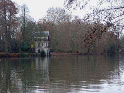 The Loiret near Olivet, south of Orléans | |
| Country | France |
| Physical characteristics | |
| Main source | 47°51′01″N 1°56′14″E / 47.8504°N 1.9372°E |
| River mouth |
Loire 47°51′52″N 1°48′02″E / 47.8644°N 1.8005°ECoordinates: 47°51′52″N 1°48′02″E / 47.8644°N 1.8005°E |
| Length | 11.6 km (7.2 mi) |
| Basin features | |
| Progression | Loire→ Atlantic Ocean |
The Loiret is a 11.6-kilometre (7.2 mi) long river in France, a left tributary to the Loire River.[1] Its waters come from infiltrations from the Loire.
Its course is completely within the Loiret département, to which it gives its name.
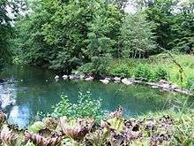
Le Bouillon
The Loiret, south of Orléans, with its picturesque former mills, is a popular destination for walking and boating trips. The source of the Loiret is a feature of the Parc Floral de la Source (Le Bouillon), and its mouth in Saint-Hilaire-Saint-Mesmin, southwest of Orléans.
References

This article is issued from
Wikipedia.
The text is licensed under Creative Commons - Attribution - Sharealike.
Additional terms may apply for the media files.