Loghill Village, Colorado
| Loghill Village, Colorado | |
|---|---|
| CDP | |
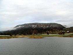 Log Hill Mesa on which sits Loghill Village | |
| Nickname(s): Loghill | |
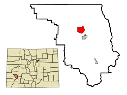 Location in Ouray County and the state of Colorado | |
| Coordinates: 38°12′7″N 107°47′8″W / 38.20194°N 107.78556°WCoordinates: 38°12′7″N 107°47′8″W / 38.20194°N 107.78556°W | |
| Country |
|
| State |
|
| County | Ouray[1] |
| Area | |
| • Total | 5.5 sq mi (14.2 km2) |
| • Land | 5.5 sq mi (14.2 km2) |
| • Water | 0 sq mi (0 km2) |
| Elevation[1] | 7,884 ft (2,403 m) |
| Population (2010) | |
| • Total | 521 |
| • Density | 56.5/sq mi (21.9/km2) |
| Time zone | UTC-7 (Mountain (MST)) |
| • Summer (DST) | UTC-6 (MDT) |
| ZIP code | 81432 |
| Area code(s) | 970 |
| FIPS code | 08-45680 |
| GNIS feature ID | 1852844 |
Loghill Village is an affluent mountain resort community on Log Hill Mesa in Ouray County, Colorado, United States. The populace of the communities in the Loghill area have been placed under the Loghill Village census-designated place (CDP). The population was 311 at the 2000 census and 521 as of the 2010 United States Census.[2]
Geography

Loghill Village is located at 38°12′7″N 107°47′8″W / 38.20194°N 107.78556°W (38.201958, -107.785653)[3] on Log Hill Mesa north of the town of Ridgway and northeast of Pleasant Valley.
According to the United States Census Bureau, the CDP has a total area of 5.5 square miles (14 km2), all of it land. Loghill Village borders Ridgway State Park and Eldredge, though there is no direct road access between the two. Via road, Loghill is nearest to the town of Ridgway which can be seen from its position on the mesa.
Loghill is primarily covered in large Ponderosa Pine trees, piñons and junipers. Wildlife is abundant on the Mesa with a fairly large population of Mule Deer, Elk, Bobcats, Lynxes, Black Bears (of various colors), wild turkeys and an occasional sighting of mountain lions. Almost 1,000 feet higher than Ridgway, the types and sizes of flora vary greatly. For example, Aspen trees are seen here and there on the mesa, as opposed to the lower Ridgway valley where they are scarce. Aspens can be seen more abundantly in the foothills and mid mountain areas of the San Juan Mountains and Cimarrons.
Demographics
| Historical population | |||
|---|---|---|---|
| Census | Pop. | %± | |
| U.S. Decennial Census[4] | |||
As of the census[5] of 2000, there were 311 people, 135 households, and 113 families residing in the CDP. The population density was 56.7 people per square mile (21.9/km²). There were 185 housing units at an average density of 33.8 per square mile (13.0/km²). The racial makeup of the CDP was 97.11% White, 0.96% Asian, 0.32% Pacific Islander, 0.32% from other races, and 1.29% from two or more races. Hispanic or Latino of any race were 0.32% of the population.
There were 135 households out of which 22.2% had children under the age of 18 living with them, 80.7% were married couples living together, 1.5% had a female householder with no husband present, and 15.6% were non-families. 11.9% of all households were made up of individuals and 4.4% had someone living alone who was 65 years of age or older. The average household size was 2.30 and the average family size was 2.47.
In the CDP the population was spread out with 16.7% under the age of 18, 1.3% from 18 to 24, 19.9% from 25 to 44, 45.0% from 45 to 64, and 17.0% who were 65 years of age or older. The median age was 50 years. For every 100 females there were 95.6 males. For every 100 females age 18 and over, there were 94.7 males.
The median income for a household in the CDP was $68,958, and the median income for a family was $69,792. Males had a median income of $42,500 versus $27,188 for females. The per capita income for the CDP was $30,034. About 5.3% of families and 6.6% of the population were below the poverty line, including 6.1% of those under age 18 and none of those age 65 or over.
Communities
Loghill Village is divided into two main communities by a shallow gorge, a common greenbelt, running southwest to northeast.[6]
- Fairway Pines - A golf course residential community in the northwest of Loghill Village. All the streets in Fairway Pines take their names from animals.[7]
- Fisher Canyon - A community north of Loghill Village with access via County Road 1.
- Loghill Village - Occupying the southeast of Log Hill mesa where most of the streets take their names from trees.[7] This community gives its name to the larger community (CDP).
Tourism
Loghill Village is primarily a residential community. There is some tourism at the golf course, the former Fairway Pines Golf Course which is now known as the Divide Ranch and Club Golf Course. There is a bar and grill restaurant, open seasonally, at the Divide golf course club house. The Loghill Village Park and Recreation Department maintains a matrix of trails on the mesa with a combined length of more than six miles. The Escarpment trail has several lookout points overlooking the town of Ridgway and Pleasant Valley with views of the Sneffels Range and Cimmaron Range. No wheeled traffic is allowed on the hiking trails.
Infrastructure
Transportation
The nearest airport with scheduled service is Montrose Regional Airport, located approximately 25 miles (40 km) to the north via road, 19 miles (31 km) northwest.[8] Loghill Village can be reached by exiting west off of U.S. Route 550 and north off State Highway 62. The latter road is also part of the San Juan Skyway Scenic Byway.[9]
See also
References
- 1 2 "US Board on Geographic Names". United States Geological Survey. 2007-10-25. Retrieved 2008-01-31.
- ↑ Colorado Trend Report 2: State and Complete Places (Sub-state 2010 Census Data). Missouri Census Data Center. Accessed 2011-02-25.
- ↑ "US Gazetteer files: 2010, 2000, and 1990". United States Census Bureau. 2011-02-12. Retrieved 2011-04-23.
- ↑ "Census of Population and Housing". Census.gov. Retrieved June 4, 2016.
- ↑ "American FactFinder". United States Census Bureau. Retrieved 2008-01-31.
- ↑ "Loghill Village CDP Limits Map". Google. Retrieved April 18, 2011.
- 1 2 "Loghill Village CDP Limits Map". Google. Retrieved April 18, 2011.
- ↑ "Maps, Weather, Videos, and Airports for Loghill Village, United States". Retrieved April 22, 2011.
- ↑ "San Juan Skyway". American's Byways. Retrieved 2011-02-06.
External links
| Wikimedia Commons has media related to Loghill Village, Colorado. |
Municipalities and communities of Ouray County, Colorado, United States | ||
|---|---|---|
| City |  | |
| Town | ||
| CDPs | ||
| Unincorporated communities | ||
| Ghost towns | ||