Loenen, Apeldoorn
| Loenen | |
|---|---|
| Village | |
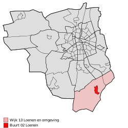 Location of Loenen in the municipality of Apeldoorn (the urban area of Beekbergen is red and the rural area is pink) | |
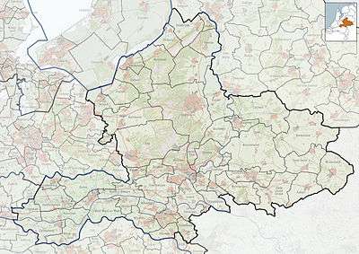 Loenen Location of Loenen in Gelderland | |
| Coordinates: 52°6′59″N 6°1′8″E / 52.11639°N 6.01889°E | |
| Country | Netherlands |
| Province | Gelderland |
| Municipality | Apeldoorn |
| Area[1] | |
| • Village | 36.9 km2 (14.2 sq mi) |
| • Urban | 1.2 km2 (0.5 sq mi) |
| Elevation[2] | 25 m (82 ft) |
| Population (January 1, 2015)[1] | |
| • Village | 3,066 |
| • Density | 83/km2 (220/sq mi) |
| • Urban | 2,116 |
| Time zone | UTC+1 (CET) |
| • Summer (DST) | UTC+2 (CEST) |
| Postcodes | 7370 and 7371 |
| Area code | 055 |
Loenen is a village in the Dutch province of Gelderland. It is located in the municipality of Apeldoorn, about 10 km southeast of that city.
Loenen was a separate municipality until 1818, when it was merged with Apeldoorn.[3]
References
- 1 2 "Apeldoorn in Cijfers" (in Dutch). Retrieved 20 October 2015.
- ↑ "Actueel Hoogtebestand Nederland: Viewer" (in Dutch). Retrieved 20 October 2015.
- ↑ Ad van der Meer and Onno Boonstra, "Repertorium van Nederlandse gemeenten", KNAW, 2006. "Archived copy". Archived from the original on 2007-02-20. Retrieved 2009-12-03.
This article is issued from
Wikipedia.
The text is licensed under Creative Commons - Attribution - Sharealike.
Additional terms may apply for the media files.