| Image |
Name |
Premise |
Number of
buildings |
Year built |
Architect |
Coordinates |
ID |
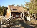 |
Aner vattenkvarn |
Boge Aner 3:2 |
1 |
Late 1800s |
|
57°41′32″N 18°46′02″E / 57.69231°N 18.76731°E / 57.69231; 18.76731 |
21300000014307 |
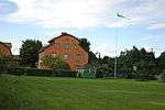 |
Annas nöje |
Östergarn Katthammars 1:14 |
6 |
1798 |
|
57°26′18″N 18°50′44″E / 57.43830°N 18.84555°E / 57.43830; 18.84555 |
21300000014894 |
|
Barlingbo prästgård |
Barlingbo Prästgården 1:8 |
3 |
1902 |
|
57°33′54″N 18°27′49″E / 57.56492°N 18.46366°E / 57.56492; 18.46366 |
21300000014305 |
 |
Bjärges i Lau |
Lau Bjärges 1:39 |
4 |
1790s |
|
57°17′04″N 18°37′58″E / 57.28435°N 18.63264°E / 57.28435; 18.63264 |
21300000014746 |
 |
Boge sockenmagasin |
Boge Annex 1:2 |
1 |
1857 |
|
57°41′14″N 18°45′48″E / 57.68717°N 18.76332°E / 57.68717; 18.76332 |
21300000014310 |
|
Bondans på Fårö |
Fårö Bondans 1:13 |
7 |
1800s |
|
57°58′08″N 19°09′11″E / 57.96895°N 19.15296°E / 57.96895; 19.15296 |
21300000014652 |
|
Boters linbastu |
Anga Boters 1:37 |
1 |
1700s or older |
|
57°28′47″N 18°40′58″E / 57.47964°N 18.68279°E / 57.47964; 18.68279 |
21300000014295 |
 |
Bottarvegården |
Vamlingbo Bottarve 1:26 |
3 |
1844 |
|
56°59′31″N 18°14′48″E / 56.99188°N 18.24668°E / 56.99188; 18.24668 |
21300000014868 |
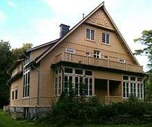 |
Brucebo |
Väskinde Stora Bläsungs 1:142, 1:24 |
6 |
Mid-1800s |
|
57°41′18″N 18°21′09″E / 57.68820°N 18.35240°E / 57.68820; 18.35240 |
21300000014875 |
|
Bruhns vattenkvarn |
Lye Lilllrone 1:3 |
3 |
1700s |
|
57°18′23″N 18°30′05″E / 57.30652°N 18.50129°E / 57.30652; 18.50129 |
21300000014762 |
|
Burs fattigstuga |
Burs S:7 |
2 |
1816 |
|
57°14′32″N 18°30′56″E / 57.24236°N 18.51547°E / 57.24236; 18.51547 |
21300000014549 |
|
Burs prästgård |
Burs Prästgården 1:11
previously 1:1 |
9 |
1700s |
|
57°14′47″N 18°30′27″E / 57.24628°N 18.50759°E / 57.24628; 18.50759 |
21300000014551 |
|
Buttle järnvägsstation |
Buttle Buttlegårde 1:79 |
7 |
1878 |
|
57°24′33″N 18°29′26″E / 57.40927°N 18.49061°E / 57.40927; 18.49061 |
21300000014559 |
|
By i Eke |
Eke By 1:1 |
5 |
1771 |
|
57°09′48″N 18°23′30″E / 57.16328°N 18.39155°E / 57.16328; 18.39155 |
21300000014574 |
 |
Båtsman Valles torp |
Lärbro Glästäde 1:16 |
2 |
1861 |
|
57°45′38″N 18°46′22″E / 57.76054°N 18.77279°E / 57.76054; 18.77279 |
21300000014767 |
 |
Dalhems prästgård |
Dalhem Prästgården 1:18
previously 1:1 |
4 |
1100s to 1500s |
|
57°33′11″N 18°31′58″E / 57.55313°N 18.53269°E / 57.55313; 18.53269 |
21300000014570 |
 |
Danielssons torp i Backhagen |
Tingstäde Furubjärs 1:6 |
3 |
Early 1700s |
|
57°44′46″N 18°38′15″E / 57.74623°N 18.63751°E / 57.74623; 18.63751 |
21300000014857 |
 |
Donnerska huset i Klinte |
Klinte Strands 1:144 |
2 |
1780s |
|
57°23′11″N 18°11′59″E / 57.38651°N 18.19959°E / 57.38651; 18.19959 |
21300000014721 |
 |
Dunbodi |
Dalhem Kaungs 1:6 |
1 |
1904 |
|
57°33′34″N 18°33′17″E / 57.55953°N 18.55479°E / 57.55953; 18.55479 |
21300000014566 |
|
Duss |
Bro Duss 1:3 |
4 |
1700s |
|
57°40′24″N 18°29′11″E / 57.67343°N 18.48640°E / 57.67343; 18.48640 |
21300000022279 |
|
Endre prästgård |
Endre Prästgården 1:10; f.d. 2:1 |
1 |
Mid-1700s |
|
57°36′35″N 18°27′54″E / 57.60961°N 18.46503°E / 57.60961; 18.46503 |
21300000014581 |
 |
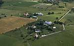
Enholmen och batteriet Mojner |
Boge Mojner 1:8, Othem Enholmen 1:1 |
5 |
1858 |
|
57°41′41″N 18°49′00″E / 57.69479°N 18.81662°E / 57.69479; 18.81662 |
21300000016436 |
.jpg) |
Etelhems krukmakeri |
Etelhem Tänglings 1:73 |
4 |
1889 |
|
57°19′48″N 18°30′29″E / 57.32987°N 18.50803°E / 57.32987; 18.50803 |
21300000014583 |