List of power stations in New Zealand
Coal/oil/gas
Geothermal
Hydro
Wind
Huntly
Stratford
Whirinaki
Wairakei
Nga Awa Purua
Mokai
Kawerau
Manapouri
Benmore
Clyde
Maraetai
Roxburgh
Tokaanu
Rangipo
Aviemore
Ohau A
Ohau B
Ohau C
Arapuni
Tekapo B
Ohakuri
Waitaki
Whakamaru
Tararua
West Wind
Location of major power stations (100 MW or over) in New Zealand.
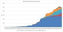
Graph of New Zealand electricity generation capacity by year.
This is a list of power stations in New Zealand.
The list is not exhaustive - only power stations over 0.5 MW and significant power stations below 0.5 MW are listed.
Bioenergy
| Name | Operator | Coordinates | Territorial authority | Type | Capacity (MW) | Commissioned | Closed |
|---|---|---|---|---|---|---|---|
| Greenmount | Vector | Auckland (Howick) | Biogas | 5.5 | 1992 | ||
| Kinleith | Oji Fibre Solutions | South Waikato | Wood cogeneration | 40 | 1997 | ||
| Omaranui | Pioneer Energy / Hastings District Council | Hastings | Biogas | 1 | 2014 | ||
| Pan Pac | Pan Pac Forest Products | Hastings | Wood cogeneration | 12.8 | 2005 | ||
| Rosedale | Mercury Energy | Auckland (Upper Harbour) | Biogas | 2.8 | 1992 | ||
| Silverstream Landfill | Pioneer Energy | Lower Hutt | Biogas | 2.7 | 1994 | ||
| Southern Landfill | Todd Energy | Wellington | Biogas | 1.1 | |||
| Tirohia | Mercury Energy | Hauraki | Biogas | 2.0 | 2008 |
Geothermal
Hydroelectric
| Name | Operator | Scheme | Coordinates | Territorial authority | Capacity (MW) | Commissioned | Closed |
|---|---|---|---|---|---|---|---|
| Amethyst | Westpower | Westland | 7.6 | 2013 | |||
| Aniwhenua | Southern Generation[2] | 38°17′37″S 176°47′32″E / 38.29369°S 176.79232°E | Whakatane | 25 | 1979 | ||
| Arapuni | Mercury Energy | Waikato River | 38°04′17″S 175°38′36″E / 38.07139°S 175.64333°E | South Waikato | 196.7 | 1929, 1946 | |
| Aratiatia | Mercury | Waikato River | 38°36′57″S 176°8′33″E / 38.61583°S 176.14250°E | Taupo | 78 | 1964 | |
| Argyle | TrustPower | Branch River | 41°40′15″S 173°12′12″E / 41.67076°S 173.203316°E | Marlborough | 3.8 | 1983 | |
| Arnold | TrustPower | 42°31′45″S 171°24′41″E / 42.52905°S 171.411267°E | Grey | 3.0 | 1932 | ||
| Atiamuri | Mercury | Waikato River | 38°23′35″S 176°1′24″E / 38.39306°S 176.02333°E | South Waikato / Taupo | 84 | 1962 | |
| Aviemore[3] | Meridian Energy | Lower Waitaki | 44°39′21″S 170°21′18″E / 44.65583°S 170.35500°E | Waitaki | 220 | 1968 | |
| Benmore[3] | Meridian Energy | Lower Waitaki | 44°33′51″S 170°11′50″E / 44.56417°S 170.19722°E | Waitaki | 540 | 1965 | |
| Cleardale | MainPower | 43°27′08.8″S 171°35′03.8″E / 43.452444°S 171.584389°E | Ashburton | 0.9 | 2010 | ||
| Clyde | Contact | Clutha River | 45°10′46″S 169°18′25″E / 45.17944°S 169.30694°E | Central Otago | 432 | 1992 | |
| Cobb | TrustPower | 41°06′13″S 172°41′16″E / 41.10361°S 172.68778°E | Tasman | 34.3 | 1956 | ||
| Coleridge | TrustPower | 43°21′51″S 171°31′37″E / 43.36417°S 171.52694°E | Selwyn | 45 | 1914 | ||
| Deep Stream | TrustPower | Waipori | Clutha | 5 | 2008 | ||
| Dillmans | TrustPower | Kumara | Westland | 3.5 | 1928 | ||
| Duffers | TrustPower | Kumara | Westland | 0.5 | 1928 | ||
| Falls | Pioneer Energy | Central Otago | 1.3 | 2003 | |||
| Flaxy | TrustPower | Wheao and Flaxy | Whakatane | 24 | 1982 | ||
| Fraser | Pioneer Energy | Central Otago | 2.8 | 1956 | |||
| Highbank[4] | TrustPower | Rangitata Diversion | 43°34′24″S 171°44′08″E / 43.573302°S 171.73557°E | Ashburton | 25.2 | 1945 | |
| Hinemaiaia A | TrustPower | Hinemaiaia | 38°53′24″S 176°05′27″E / 38.890086°S 176.090875°E | Taupo | 2.0 | 1952 | |
| Hinemaiaia B | TrustPower | Hinemaiaia | Taupo | 1.3 | 1966 | ||
| Hinemaiaia C | TrustPower | Hinemaiaia | Taupo | 2.8 | 1982 | ||
| Horseshoe Bend | Pioneer Energy | Central Otago | 4.3 | 1999 | |||
| Kaimai 5 | TrustPower | Kaimai | Western Bay of Plenty | 0.35 | 1994 | ||
| Kaitawa | Genesis Energy | Waikaremoana | 38°48′12″S 177°07′52″E / 38.80323°S 177.1311°E | Wairoa | 36 | 1948 | |
| Kaniere Forks | TrustPower | Lake Kaniere | Westland | 0.43 | 1911 | ||
| Karapiro | Mercury | Waikato River | 37°55′26″S 175°32′21″E / 37.92389°S 175.53917°E | Waipa | 90 | 1948 | |
| Kourarau | Genesis Energy | Carterton | 1.0 | 1923, 1925 | |||
| Kowhai | Pioneer Energy | Central Otago | 1.9 | 2010 | |||
| Kumara | TrustPower | Kumara | Westland | 6.5 | 1928 | ||
| Lloyd Mandeno | TrustPower | Kaimai | Western Bay of Plenty | 15.6 | 1972 | ||
| Lower Mangapapa | TrustPower | Kaimai | Western Bay of Plenty | 6.0 | 1979 | ||
| Manapouri | Meridian Energy | 45°31′17″S 167°16′40″E / 45.52139°S 167.27778°E | Southland | 850 | 1971 | ||
| Mangahao | Todd Energy | 40°34′36″S 175°27′1″E / 40.57667°S 175.45028°E | Horowhenua | 42 | 1924 | ||
| Mangorei | Trustpower | New Plymouth | 4.5 | 1906, 1931 | |||
| Maraetai I | Mercury | Waikato River | 38°21′09″S 175°44′38″E / 38.35250°S 175.74389°E | South Waikato / Taupo | 252 | 1954 | |
| Maraetai II | Mercury | Waikato River | South Waikato / Taupo | 108 | 1971 | ||
| Maraetai (mini) | Mercury | South Waikato / Taupo | 0.1 | ||||
| Matahina | Trustpower | 38°06′54″S 176°48′52″E / 38.114908°S 176.814473°E | Whakatane | 72 | 1967 | ||
| McKays Creek | Trustpower | Lake Kaniere | Westland | 1.1 | 1931 | ||
| Monowai | Pioneer Energy | Southland | 6.6 | 1926 | |||
| Montalto[4] | Trustpower | Rangitata Diversion | Ashburton | 1.8 | 1982 | ||
| Motukawa | TrustPower | New Plymouth | 4.5 | 1927-1938 | |||
| Ohakuri | Mercury | Waikato River | 38°24′30″S 176°5′22″E / 38.40833°S 176.08944°E | South Waikato / Taupo | 112 | 1962 | |
| Ohau A[3] | Meridian Energy | Upper Waitaki | 44°15′52″S 170°1′56″E / 44.26444°S 170.03222°E | Mackenzie | 264 | 1980 | |
| Ohau B[3] | Meridian Energy | Upper Waitaki | 44°17′58″S 170°6′44″E / 44.29944°S 170.11222°E | Waitaki | 212 | 1984 | |
| Ohau C[3] | Meridian Energy | Upper Waitaki | 44°20′31″S 170°10′56″E / 44.34194°S 170.18222°E | Waitaki | 212 | 1985 | |
| Opuha | Opuha Water / TrustPower | Mackenzie | 7.5 | 1999 | |||
| Oxburn/Glenorchy | Pioneer Energy | Queenstown Lakes | 0.4 | 1968 | |||
| Paerau | Trustpower | Strath Taieri | Central Otago | 10 | 1984 | ||
| Patea | Trustpower | 39°32′46″S 174°34′13″E / 39.54611°S 174.57028°E | South Taranaki | 32 | 1984 | ||
| Patearoa | Trustpower | Strath Taieri | Central Otago | 2.3 | 1984 | ||
| Piripaua | Genesis Energy | Waikaremoana | 38°50′21″S 177°10′05″E / 38.83906°S 177.16817°E | Wairoa | 42 | 1943 | |
| Pupu | Pupu Hydro Society | Tasman | 0.3 | 1929 | |||
| Rangipo | Genesis Energy | Tongariro | 39°09′12″S 175°50′12″E / 39.153316°S 175.836802°E | Taupo | 120 | 1983 | |
| Rimu | Trustpower | Esk | Hastings | 2.4 | 2013 | ||
| Roaring Meg lower | Pioneer Energy | Roaring Meg | Central Otago / Queentown Lakes | 3.0 | 1936 | ||
| Roaring Meg upper | Pioneer Energy | Roaring Meg | Central Otago / Queentown Lakes | 1.3 | 1936 | ||
| Roxburgh | Contact | Clutha River | 45°28′33″S 169°19′21″E / 45.475811°S 169.322555°E | Central Otago | 320 | 1956 | |
| Ruahihi | Trustpower | Kaimai | Western Bay of Plenty | 20 | 1981 | ||
| Tekapo A[3] | Genesis Energy | Upper Waitaki | 44°00′50″S 170°27′38″E / 44.013805°S 170.460516°E | Mackenzie | 25 | 1951 | |
| Tekapo B[3] | Genesis Energy | Upper Waitaki | 44°07′21″S 170°12′43″E / 44.12253°S 170.211947°E | Mackenzie | 160 | 1977 | |
| Tokaanu | Genesis Energy | Tongariro | 38°58′52″S 175°46′06″E / 38.98113°S 175.768282°E | Taupo | 240 | 1973 | |
| Toronui | TrustPower | Esk | Hastings | 1.4 | 2013 | ||
| Tuai | Genesis Energy | Waikaremoana | 38°48′25″S 177°09′03″E / 38.806819°S 177.150844°E | Wairoa | 60 | 1929 | |
| Wahapo/Ōkārito Forks | Trustpower | Westland | 3.1 | 1960 | |||
| Waihopai | Trustpower | 39°09′12″S 175°50′12″E / 39.153316°S 175.836802°E | Marlborough | 2.5 | 1927 | ||
| Waipapa | Mercury | Waikato River | 38°17′32″S 175°41′01″E / 38.29216°S 175.683568°E | South Waikato | 51 | 1961 | |
| Waipori 1A | Trustpower | Waipori | Clutha | 10 | |||
| Waipori 2A | Trustpower | Waipori | Clutha | 58 | |||
| Waipori 3 | Trustpower | Waipori | Clutha | 7.6 | |||
| Waipori 4 | Trustpower | Waipori | Clutha | 8 | |||
| Wairua | Northpower | 35°45′27″S 174°04′03″E / 35.75753°S 174.067619°E | Whangarei | 5.0 | 1916 | ||
| Waitaki[3] | Meridian Energy | Lower Waitaki | 44°41′23″S 170°25′34″E / 44.68983°S 170.426173°E | Waitaki | 90 | 1935 | |
| Whakamaru | Mercury | Waikato River | 38°25.178′S 175°48.493′E / 38.419633°S 175.808217°E | South Waiakto / Taupo | 100 | 1956 | |
| Wheao | Trustpower | Wheao and Flaxy | 38°38′00″S 176°34′41″E / 38.633332°S 176.578077°E | Whakatane | 24 | 1982 |
| Name | Location | Type | Operator | Capacity (MW) | Commissioned | Notes |
|---|---|---|---|---|---|---|
| Brooklyn (hydro) | near Motueka, Tasman | 0.2 | 1934 | |||
| Drysdale | near Marton, Manawatu-Wanganui | Drysdale Hydro Company | 0.1 | |||
| Feredays Island | Canterbury | Hydro Run of River | Kea Energy | 0.3 | 2005 | |
| Fox | West Coast | Trustpower | 0.2 | |||
| Kuratau | King Country Energy | 6.0 | 1962 | |||
| Mangapehi | Waikato | Clearwater Hydro | 1.6 | 2008 | ||
| Mangatangi | Franklin, Auckland | Watercare Services | 0.6 | |||
| Mangatawhiri | Franklin, Auckland | Counties Power | 0.2 | |||
| Marokopa | Waitomo area, Waikato | Clearwater Hydro | 2.0 | |||
| Mataura | near Gore, Southland | Niblick Trust | 0.9 | |||
| Matawai | Gisborne | Clearwater Hydro | 2.0 | 2009 | ||
| Mokauiti | Central North Island | King Country Energy | 1.9 | 1925, 1938, 1963 | ||
| Ngahere | West Coast | Birchfield Minerals | 0.1 | |||
| Normanby | Hawera, Taranaki | run-of-river | Renewable Power Ltd | 1.0 | 1903, 2015 | Supplied electricity to Hawera until 1967 |
| Onekaka | Tasman District | Onekaka Energy | 1.0 | |||
| Opunake | Opunake, Taranaki | TrustPower | 0.3 | |||
| Piriaka | Central North Island 38°52′46″S 175°44′08″E / 38.879502°S 175.735514°E | King Country Energy | 1.8 | 1924 | ||
| Raetihi | Raetihi, Manawatu-Wanganui | Trustpower | 0.3 | |||
| Rochfort | Westport, West Coast | Kawatiri Energy | 4.2 | 2013 | ||
| Talla Burn | Central Otago | Talla Burn Generation | 2.6 | 2010 | ||
| Teviot | east of Roxburgh, Otago | Pioneer Energy | 10.5 | 1983 | ||
| Turitea (hydro) | near Palmerston North | Palmerston North City Council | 0.1 | |||
| Waihi Station | near Wairoa, Hawke's Bay | Trustpower | 4.7 | 1913 | ||
| Wairere Falls | Central North Island 38°31′54″S 175°00′30″E / 38.531654°S 175.008291°E | King Country Energy | 4.9 | 1963 |
Source:[5]
Decommissioned hydroelectric
| Name | Location | Type | Last Operator | Capacity (MW) | Commissioned | Decommissioned | Notes |
|---|---|---|---|---|---|---|---|
| Bullendale | Queenstown | 2 Pelton wheels | Phoenix Mine | 0.04 | 1886 | 1907 | First industrial generation in NZ |
| Okere Falls | north-east of Rotorua | NZ Government | 0.2 | 1901 | 1936 | First power station owned by government. Dismantled in 1941 | |
| Omanawa Falls | south-east of Tauranga | Trust Power | 0.75 | 1915, extended 1921 | 1990s | First underground power station in New Zealand, built by Tauranga Borough Council. [6] | |
| Horahora | east of Cambridge, Waikato | State Hydro Department | 10.3 | 1913 | 1947 | Drowned by formation of Lake Karapiro | |
| Reefton | Reefton, West Coast | Grey Electric Power Board | <1 | 1888 | 1949 | Demolished | |
| Wye Creek | Otago-Southland | Pioneer Energy | 1.3 | 1936 | 2008 | Mothballed after turbine/generator failure |
Fossil fuel
| Name | Operator | Coordinates | Territorial authority | Type | Capacity (MW) | Commissioned | Closed |
|---|---|---|---|---|---|---|---|
| Auckland Hospital | Auckland DHB / Pioneer Energy | Auckland (Waitemata) | Gas/Diesel cogeneration | 3.6 | 2005 | ||
| Bream Bay | TrustPower | Whangarei | Diesel recip engine | 9 | 2011 | ||
| Edgecumbe | Nova Energy | Whakatane | Gas cogeneration | 10 | 1996 | ||
| Evans Bay | Wellington MED | Wellington | Coal steam turbine | 23 | 1924 | 1968 | |
| Glenbrook | Alinta | Auckland (Franklin) | Coal/Gas waste heat | 112 | 1997 | ||
| Huntly 1-4 | Genesis Energy | 37°32′40″S 175°09′01″E / 37.544475°S 175.150412°E | Waikato | Coal/Gas steam turbine | 500 | 1983 | |
| Huntly 5 | Genesis Energy | 37°32′35″S 175°08′57″E / 37.543046°S 175.149103°E | Waikato | Gas combined-cycle | 400 | 2007 | |
| Huntly 6 | Genesis Energy | 37°32′38″S 175°08′53″E / 37.543982°S 175.14814°E | Waikato | Gas/Diesel open-cycle | 50 | 2004 | |
| Kapuni | Vector / Bay of Plenty Energy | South Taranaki | Gas combined-cycle cogeneration | 25 | 1998 | ||
| Kawerau (TPP) | Tasman Pulp and Paper | Kawerau | Gas cogeneration | 37 | 1966 | ||
| Kings Wharf | Auckland Harbour Board | Auckland (Waitemata) | Coal steam turbine | 10.5 | 1920 | 1968 | |
| Kinleith | Genesis Energy | South Waikato | Wood/Gas cogeneration | 40 | 1998 | ||
| Mangahewa | Todd Energy | New Plymouth | Gas | 9.0 | 2008 | ||
| Marsden A | ECNZ | Whangarei | Oil | 240 | 1967 | 1997 | |
| Marsden B | ECNZ | Whangarei | Oil | 250 | never commissioned | ||
| McKee (recip) | Todd Energy | New Plymouth | Gas reciprocating | 2.0 | 2008 | ||
| McKee (turbine) | Todd Energy | New Plymouth | Gas open-cycle | 100 | 2013 | ||
| Meremere | ECNZ | Waikato | Coal steam turbine | 210 | 1958 | 1991 | |
| New Plymouth | Contact Energy | New Plymouth | Gas/Oil steam turbine | 600 | 1974 | 2008 | |
| Otahuhu A | Contact Energy | Auckland (Otara-Papatoetoe) | Gas open cycle | 1968 | late 1990s | ||
| Otahuhu B | Contact Energy | Auckland (Otara-Papatoetoe) | Gas combined cycle | 404 | 2000 | 2015 | |
| Palmerston North[7] | Palmerston North MED | Palmerston North | Town Gas/Diesel reciprocating | 2 | 1924 | 1992 | |
| QE2 Park | Orion New Zealand | Christchurch | Diesel recip engine | 4 | 2011-2 | ||
| Southdown | Mercury Energy | 36°55′39″S 174°49′38″E / 36.927563°S 174.827328°E | Auckland (Maungakiekie-Tamaki) | Gas combined-cycle cogeneration | 170 | 1997 | 2015 |
| Springlands[8] | Marlborough Lines | Marlborough | Diesel reciprocating | 1.5 | 1930 | 2003 | |
| Stratford CC | Contact Energy | 39°19′56″S 174°19′8″E / 39.33222°S 174.31889°E | Stratford | Gas combined-cycle | 385 | 1998 | |
| Stratford peaker | Contact Energy | 39°19′56″S 174°19′8″E / 39.33222°S 174.31889°E | Stratford | Gas open-cycle | 200 | 1998 | |
| Te Awamutu | Genesis Energy | Waipa | Gas turbine | 54 | 1995 | 2007 | |
| Te Rapa | Contact Energy | 37°42′59″S 175°13′0″E / 37.71639°S 175.21667°E | Hamilton | Gas cogeneration | 44 | 1999 | |
| Wellington Hospital | Capital & Coast DHB / Vector / Meridian Energy | Wellington | Gas/Oil cogeneration | 8 | 1981 | ||
| Whareroa | Fonterra / Todd Energy | South Taranaki | Gas combined-cycle cogeneration | 69.6 | 1996 | ||
| Whirinaki | Contact Energy | 39°22′34″S 176°53′36″E / 39.37611°S 176.89333°E | Hastings | Diesel open-cycle | 155 | 2004 |
Source:[5]
Wind
| Name | Operator | Coordinates | Territorial authority | Number of Turbines | Capacity (MW) | Commissioned | Closed |
|---|---|---|---|---|---|---|---|
| Brooklyn Wind Turbine (original) | Meridian Energy | Wellington | 1 | 0.23 | 1993 | 2015 | |
| Brooklyn Wind Turbine (new) | Meridian Energy | Wellington | 1 | 0.9 | 2016 | ||
| Chatham Islands Wind Farm | CBD Energy / Chatham Islands Enterprise Trust | 44°2′13″S 176°23′0″W / 44.03694°S 176.38333°W | Chatham Islands | 2 | 0.46 | 2010 | |
| Gebbies Pass | Windflow Technology | 43°41′54″S 172°38′27″E / 43.69833°S 172.64083°E | Christchurch | 1 | 0.5 | 2003 | |
| Hau Nui | Genesis Energy | 41°21′42″S 175°29′2″E / 41.36167°S 175.48389°E | South Wairarapa | 15 | 8.7 | 1996, 2004 | |
| Horseshoe Bend | Pioneer Energy | Central Otago | 3 | 2.3 | 2009 | ||
| Lulworth[9] | Energy 3 | Marlborough | 4 | 1.0 | 2011 | ||
| Mahinerangi | Tilt Renewables | 45°45′38″S 169°54′18″E / 45.76056°S 169.90500°E | Dunedin | 12 | 36 | March 2011 | |
| Mill Creek | Meridian Energy | Wellington | 26 | 60 | 2014 | ||
| Mt Stuart[10] | Pioneer Energy | 46°04′20″S 169°46′2″E / 46.07222°S 169.76722°E | Clutha | 9 | 7.7 | December 2011 | |
| Southbridge | Energy 3 | Selwyn | 1 | 0.1 | 2005 | ||
| Tararua | Tilt Renewables | 40°20′46″S 175°46′48″E / 40.34611°S 175.78000°E | Palmerston North / Tararua | 134 | 161 | 1999, 2004, 2007 | |
| Te Apiti | Meridian Energy | 40°17′46″S 175°48′30″E / 40.29611°S 175.80833°E | Palmerston North / Tararua | 55 | 91 | 2004 | |
| Te Rere Hau | New Zealand Windfarms | 40°23′18″S 175°43′27″E / 40.38833°S 175.72417°E | Palmerston North / Tararua | 97 | 48.5 | 2006, 2009, 2011 | |
| Te Uku | Meridian Energy / WEL Networks | 37°52′42″S 174°57′47″E / 37.87833°S 174.96306°E | Waikato | 28 | 64.4 | 2011 | |
| Weld Cone | Energy 3 | Marlborough | 3 | 0.8 | 2010 | ||
| West Wind | Meridian Energy | 41°16′35″S 174°39′37″E / 41.27639°S 174.66028°E | Wellington | 62 | 143 | 2009 | |
| White Hill | Meridian Energy | 45°45′9″S 168°16′18″E / 45.75250°S 168.27167°E | Southland | 29 | 58 | 2007 |
Grid battery storage
| Name | Operator | Coordinates | Territorial authority | Type | Capacity (MW/MWh) | Commissioned | Closed |
|---|---|---|---|---|---|---|---|
| Glen Innes | Vector | Auckland (Manugakiekie-Tamaki) | Tesla Powerpack | 1.0/2.3 | 2016 | ||
| Hobsonville Point | Vector | Auckland (Upper Harbour) | Tesla Powerpack | 1.0/2.3 | 2018 |
Proposed power stations
| Name | Location | Type | Operator | Planned Capacity (MW) | Status | Notes |
|---|---|---|---|---|---|---|
| Amuri | North Canterbury | Hydro | Meridian Energy | 38 | applied for consent | [11] |
| Arnold (Dobson) | east of Greymouth, West Coast | Hydro | TrustPower | 46 | consented | [11] |
| Awhitu | near Waiuku, Auckland | Wind | Tilt Renewables | 18 | consented | [11] |
| Balmoral | Canterbury | Hydro | Meridian Energy | 15 | applied for consent | [11] |
| Belfast | Belfast, Christchurch | Diesel | Orion New Zealand | 11.5 | consented | [11] |
| Bromley | Bromley, Christchurch | Diesel | Orion New Zealand | 11.5 | consented | [11] |
| Brooklyn Wind Turbine replacement | Brooklyn, Wellington | Wind | Meridian Energy | 0.9 | applied for consent | [13] |
| Castle Hill | northeast of Masterton | Wind | Genesis Energy | 860 | consented | [11][14] |
| Central Wind (Moawhango) | between Taihape and Waiouru | Wind | Meridian Energy | 130 | consented | [11] |
| Cook Strait | Neptune Power | Tidal | near Wellington | 1 | consented | [11] |
| Flat Hill | near Bluff, Southland | Wind | Energy 3 | 7 | consented | [11] |
| Hauauru ma raki | Waikato coast | Wind | Contact Energy | 504 | consented | [11] |
| Hawea Gates | near Wanaka, Otago | Hydro | Contact Energy | 17 | consented | [11] |
| Hurunui | North Canterbury | Wind | Meridian Energy | 76 | consented | [11][15] |
| Junction Road | Taranaki | Gas | Nova Energy | 100 | consented | [11] |
| Kaipara | Kaipara Harbour, Northland | Tidal | Crest Energy | 200 | consented | [11][16] |
| Kaiwera Downs | south-east of Gore, Southland | Wind | Tilt Renewables | 240 | consented | [11] |
| Lake Coleridge | inland Canterbury | Hydro | TrustPower | 70 | applied for consent | [11] |
| Lake Pukaki | near Twizel, Canterbury | Hydro | Meridian Energy | 35 | consented | [11][17] |
| Long Gully | Wellington | Wind | Windflow Technologies | 12.5 | consented | [11] |
| Mahinerangi stage 2 | Lake Mahinerangi, west of Dunedin | Wind | Tilt Renewables | 164 | consented | [11] |
| Matiri Project | West Coast | Hydro | New Zealand Energy | 5 | applied for consent | |
| Maungaharuru | inland Hawke's Bay | Wind | Meridian Energy | 225 | consented | |
| Mokau | Taranaki | Hydro | King Country Energy | 10 | applied for consent | |
| Mount Cass | Canterbury | Wind | MainPower | 69 | consented | |
| North Bank | Waitaki River, Canterbury | Hydro | Meridian Energy | 280 | applied for consent | |
| Otahuhu C | Otahuhu, Auckland | Gas | Contact Energy | 400 | consented | |
| Puketiro | Wellington | Wind | RES | 150 | ||
| Puketoi | Manawatu | Wind | Mercury Energy | 159 | consented[18] | |
| Rakaia River | Canterbury | Hydro | Ashburton Community Water Trust | 16 | consented | |
| Rodney | near Helensville, Auckland | Gas | Genesis Energy | 480 | consented | |
| Rotoma | Bay of Plenty | Geothermal | Rotoma No 1 Corporation | 35 | applied for consent | |
| Rototuna | Northland | Wind | Meridian Energy | 500 | ||
| Slopedown | east of Gore, Southland | Wind | Genesis Energy | 150 | [19] | |
| Stockton Mine | West Coast | Hydro | Solid Energy | 35 | consented | [11][20] |
| Stockton Plateau | West Coast | Hydro | Hydro Developments | 25 | consented | |
| Tauhara 2 | north-east of Taupo | Geothermal | Contact Energy | 250 | consented[21] | |
| Te Ahi o Maui | Bay of Plenty | Geothermal | Eastland Group | 12.5 | applied for consent | [11] |
| Titiokura | Hawkes Bay | Wind | Unison / Roaring 40s | 48 | consented | |
| Tory Channel | Marlborough | Tidal | Energy Pacifica | 10 | ||
| Turitea | near Palmerston North | Wind | Mercury Energy | 180 | consent under appeal | [11] |
| Upper Kaituna | Bay of Plenty | Hydro | Bay of Plenty Energy | 14 | ||
| Wairau | Nelson-Marlborough | Hydro | Trustpower | 70.5 | consented | |
| Waitahora | east of Dannevirke, Manawatu-Wanganui | Wind | Contact Energy | 156 | consented | [11] |
| Waverley | South Taranaki | Wind | Tilt Renewables | 130 | applied for consent |
Source:[11]
See also
References
- ↑ PowerStations.kmz file (compressed, ~200KB) via the Centralised Dtaaset DVD from the Electricity Commission, or via Dropbox (251KB) https://www.dropbox.com/s/a35lz3bs1cvlsc9/PowerStations.kmz?dl=0 also http://www.emi.ea.govt.nz/Datasets/Browse?directory=/StationList&parentDirectory=/Datasets/Wholesale/Archive/201310_Centralised_dataset/CentralisedDataset/NetworkConfiguration/Generation See the substations and transmission lines via Network.kmz (2MB) on the DVD or via https://www.dropbox.com/s/z6c33jsob4zynin/Network.kmz?dl=0 also http://www.emi.ea.govt.nz/Datasets/Browse?directory=/TransmissionLineLocations&parentDirectory=/Datasets/Wholesale/Archive/201310_Centralised_dataset/CentralisedDataset/NetworkConfiguration/TransmissionNetwork
- ↑ Mack, Ben; McCarthy, Phil (3 December 2015). "Southern Generation buys North Island power station for $100m". Dominion Post.
- 1 2 3 4 5 6 7 8 "Discover the Waitaki Hydro Scheme" (PDF). Meridian Energy Ltd. p. 5. Archived from the original (PDF) on 17 February 2011. Retrieved 23 June 2010.
- 1 2 "Highbank/Montalto". TrustPower. Archived from the original on 2009-01-26. Retrieved 2009-03-29.
- 1 2 3 "Generating station list as at September 2012" (xls). New Zealand Electricity Authority. Retrieved 2013-05-12.
- ↑ "Omanawa Falls Power Station". NZ Historic Places Trust.
- ↑ "Palmerston North Electric Power Station Inc". webring.com. Retrieved 28 May 2015.
- ↑ "Marlborough Lines News". marlboroughlines.co.nz. Archived from the original on 7 April 2012. Retrieved 28 May 2015.
- ↑ "Lulworth". New Zealand Wind Energy Association. Archived from the original on 19 November 2010. Retrieved 14 December 2010.
- ↑ "Proposed Mt Stuart Windfarm Information". Clutha District Council. Archived from the original on 2009-03-01. Retrieved 2009-02-06.
- 1 2 3 4 5 6 7 8 9 10 11 12 13 14 15 16 17 18 19 20 21 22 23 24 25 26 "Generation update". New Zealand Electricity Authority. October 2013. Archived from the original on 16 April 2014. Retrieved 20 April 2014.
- ↑ "Wind farms operating and under construction - New Zealand Wind Energy Association". Archived from the original on 2011-02-03. Retrieved 2011-02-10.
- ↑ "Turbine being replaced after 20 years of service". The Dominion Post (via Stuff.co.nz). 2 September 2013. Retrieved 19 April 2014.
- ↑ "Genesis planning massive windfarm". NZ Herald. 30 August 2011. Retrieved 1 September 2011.
- ↑ Williams, David (2010-04-03). "$200m North Canty wind farm planned". The Press.
- ↑ Thompson, Wayne (8 February 2011). "Tidal power station for Kaipara approved". Retrieved 11 February 2011.
- ↑ Bruce, David (16 June 2011). "Pukaki hydro scheme gains resource consent". Otago Daily Times.
- ↑ "Mighty River Power lodges application for wind development at Puketoi" (Press release). Mighty River Power. 3 August 2011. Archived from the original on 4 October 2011.
- ↑ "Slopedown Wind Farm". Genesis Energy. Archived from the original on 17 December 2010. Retrieved 14 February 2011.
- ↑ "Stockton Hydro Scheme". Solid Energy. Archived from the original on 2010-05-23.
- ↑ "Tauhara 2 gains consent". Contact Energy. 22 December 2010. Archived from the original on 27 September 2011. Retrieved 9 February 2010.
Further reading
- Martin, John E. (1991). People, politics and power stations : electric power generation in New Zealand, 1880-1990. ISBN 0-908912-16-1.
- "Energy in New Zealand 2015". MBIE. August 2015.
External links
- Identification of Potential Hydroelectric Resources - a report prepared for the Ministry of Economic Development in January 2004
This article is issued from
Wikipedia.
The text is licensed under Creative Commons - Attribution - Sharealike.
Additional terms may apply for the media files.