List of protected heritage sites in Vielsalm
This table shows an overview of the protected heritage sites in the Walloon town Vielsalm. This list is part of Belgium's national heritage.
| Object |
Year/architect |
Town/section |
Address |
Coordinates |
Number? |
Image |
|---|---|---|---|---|---|---|
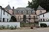
| Château des Comtes de Salm and environment (nl) (fr) |
Vielsalm | Rue du Vieux Château, Salmchâteau | 50°16′06″N 5°54′18″E / 50.268261°N 5.904872°E |
82032-CLT-0001-01 Info |
.JPG) | |
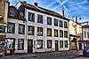
| building (nl) (fr) |
Vielsalm | Burtonville n°33 | 50°17′01″N 5°57′59″E / 50.283577°N 5.966257°E |
82032-CLT-0002-01 Info |
||
| Fange du Grand Passage (nl) (fr) |
Vielsalm | 50°13′57″N 5°44′54″E / 50.232607°N 5.748364°E |
82032-CLT-0003-01 Info |
|||
| Coticule quarry situated near "Les Minières" (nl) (fr) |
Vielsalm | 50°14′53″N 5°48′55″E / 50.247953°N 5.815212°E |
82032-CLT-0004-01 Info |
|||
| Ensemble of the quarry of Renard (nl) (fr) |
Vielsalm | 50°16′28″N 5°55′26″E / 50.274339°N 5.923837°E |
82032-CLT-0005-01 Info |
 | ||
| Agrarian structure (farm) (nl) (fr) |
Vielsalm | rue Rocher de Hourt n°6 | 50°19′08″N 5°54′31″E / 50.318916°N 5.908678°E |
82032-CLT-0006-01 Info |
||
| Château Commanster (former "Maison Merget"): facades, roofs and interior left side and the entrance portal (nl) (fr) |
Vielsalm | n°s 14-15, Beho | 50°15′09″N 6°00′01″E / 50.252493°N 6.000330°E |
82032-CLT-0014-01 Info |
||
| Farm Gesnot and the ensemble of the farm and the environment (nl) (fr) |
Vielsalm | n°18 | 50°15′08″N 5°53′54″E / 50.252253°N 5.898262°E |
82032-CLT-0015-01 Info |
 | |
| Castle farm "Flamang": facades and roofs and the ensemble of the castle and the domain on which it resides. (nl) (fr) |
Vielsalm | n°25 | 50°15′06″N 5°53′48″E / 50.251544°N 5.896556°E |
82032-CLT-0017-01 Info |
 | |
| House façade, roof cladding and slate of the southern gable (nl) (fr) |
Vielsalm | rue Général Jacques n°14 | 50°17′11″N 5°54′59″E / 50.286505°N 5.916487°E |
82032-CLT-0020-01 Info |
 | |
| House façade, roof, gable and northern portico (nl) (fr) |
Vielsalm | rue G. Jacques n°12 | 50°17′12″N 5°54′59″E / 50.286582°N 5.916450°E |
82032-CLT-0021-01 Info |
 | |
| House (nl) (fr) |
Vielsalm | rue du Général Jacques, n°14 (ancien n°12): façade arrière y compris la tour d'escalier extérieur de la maison. | 50°17′12″N 5°54′59″E / 50.286560°N 5.916321°E |
82032-CLT-0022-01 Info |
 | |
| Cross in Joubiéval on the corner of Route d'Ottré left of n ° 43 (nl) (fr) |
Vielsalm | 50°15′33″N 5°50′54″E / 50.259180°N 5.848317°E |
82032-CLT-0025-01 Info |
 | ||
| Cross in Fraiture in front of no ° 23 (nl) (fr) |
Vielsalm | 50°15′32″N 5°45′10″E / 50.258828°N 5.752781°E |
82032-CLT-0027-01 Info |
 | ||
| Eastern part of the valley between Glain Vielsalm and Salmchâteau called "la Fosse roulette" (nl) (fr) |
Vielsalm | 50°16′20″N 5°54′27″E / 50.272252°N 5.907436°E |
82032-CLT-0028-01 Info |
 | ||
| The marsh of Grand Passage (nl) (fr) |
Vielsalm | 50°13′57″N 5°44′54″E / 50.232607°N 5.748364°E |
82032-PEX-0001-01 Info |
See also
| Wikimedia Commons has media related to Cultural heritage monuments in Vielsalm. |
References
- Belgian heritage register: Direction générale opérationnelle - Aménagement du territoire, Logement, Patrimoine et Energie (DG4)
- www.dglive.be
This article is issued from
Wikipedia.
The text is licensed under Creative Commons - Attribution - Sharealike.
Additional terms may apply for the media files.