List of protected heritage sites in Rouvroy, Belgium
This table shows an overview of the protected heritage sites in the Walloon town Rouvroy, Belgium. This list is part of Belgium's national heritage.
| Object |
Year/architect |
Town/section |
Address |
Coordinates |
Number? |
Image |
|---|---|---|---|---|---|---|
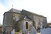
| Church of Saint-Quentin (nl) (fr) |
Rouvroy | Montquintin | 49°32′42″N 5°28′26″E / 49.544904°N 5.473813°E |
85047-CLT-0002-01 Info |
 | |
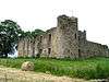
| Ruins of castle Dampicourt (nl) (fr) |
Rouvroy | 49°32′44″N 5°28′22″E / 49.545587°N 5.472679°E |
85047-CLT-0003-01 Info |
 | ||
| Entire site of Montquintin (nl) (fr) |
Rouvroy | 49°32′44″N 5°28′21″E / 49.545569°N 5.472382°E |
85047-CLT-0004-01 Info |
| ||
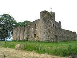
| Manor farm of the castle (facades and roofs), all of the dovecote and the surrounding wall (nl) (fr) |
Rouvroy | rue du Château fort, n°12 | 49°32′41″N 5°28′23″E / 49.544774°N 5.472941°E |
85047-CLT-0005-01 Info |
||
| Museum of Rural Life, historical museum (nl) (fr) |
Rouvroy | place Montseigneur de Hontheim | 49°32′41″N 5°28′24″E / 49.544774°N 5.473380°E |
85047-CLT-0006-01 Info |
 | |
| St. Martin's Church: tower (nl) (fr) |
Rouvroy | 49°32′18″N 5°29′29″E / 49.538307°N 5.491373°E |
85047-CLT-0007-01 Info |
|||
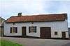
| farm (nl) (fr) |
Rouvroy | rue Péchières, n°6 | 49°30′33″N 5°28′25″E / 49.509174°N 5.473718°E |
85047-CLT-0009-01 Info |
||
| Nature reserve of Raymond Mayné (nl) (fr) |
Rouvroy | 49°30′40″N 5°28′43″E / 49.511115°N 5.478620°E |
85047-CLT-0011-01 Info |
|||
| Ensemble of Chapel of Notre-Dame de Luxembourg, the refuge area (nl) (fr) |
Rouvroy | rue de l'Ermitage | 49°30′32″N 5°28′56″E / 49.508798°N 5.482190°E |
85047-CLT-0013-01 Info |
||
| Farm (facades and roofs) (nl) (fr) |
Rouvroy | rue de Mathon, n°21 | 49°33′15″N 5°29′59″E / 49.554305°N 5.499776°E |
85047-CLT-0014-01 Info |
||
| Washing place (nl) (fr) |
Rouvroy | rue Grande | 49°30′29″N 5°28′27″E / 49.508106°N 5.474168°E |
85047-CLT-0015-01 Info |
||
| House (nl) (fr) |
Rouvroy | rue Jean, n°15 | 49°30′23″N 5°28′23″E / 49.506310°N 5.473180°E |
85047-CLT-0016-01 Info |
||
| Area Montquintin (area of special value) (nl) (fr) |
Rouvroy | 49°32′44″N 5°28′21″E / 49.545569°N 5.472382°E |
85047-PEX-0001-01 Info |
 |
See also
| Wikimedia Commons has media related to Cultural heritage monuments in Rouvroy, Belgium. |
References
- Belgian heritage register: Direction générale opérationnelle - Aménagement du territoire, Logement, Patrimoine et Energie (DG4)
- www.dglive.be
This article is issued from
Wikipedia.
The text is licensed under Creative Commons - Attribution - Sharealike.
Additional terms may apply for the media files.