List of protected heritage sites in Péruwelz
This table shows an overview of the protected heritage sites in the Walloon town Péruwelz. This list is part of Belgium's national heritage.
| Object |
Year/architect |
Town/section |
Address |
Coordinates |
Number? |
Image |
|---|---|---|---|---|---|---|
| House facade and roof front (nl) (fr) |
Péruwelz | Grand-Place n°4 | 50°30′36″N 3°35′40″E / 50.509941°N 3.594427°E |
57064-CLT-0002-01 Info |
||
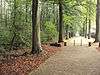
| Ruins of Castle and E. Simon municipal park (nl) (fr) |
Péruwelz | 50°30′30″N 3°35′28″E / 50.508304°N 3.591185°E |
57064-CLT-0003-01 Info |
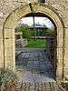 | ||
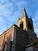
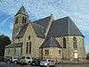
| Tower and portico of the church of Saint-Quentin (nl) (fr) |
Péruwelz | 50°30′27″N 3°35′22″E / 50.507455°N 3.589487°E |
57064-CLT-0004-01 Info |
.JPG) | ||
| Rectory and parish St. Quentin: facades and roofs (nl) (fr) |
Péruwelz | rue de Sondeville, n°2 | 50°30′26″N 3°35′22″E / 50.507177°N 3.589465°E |
57064-CLT-0005-01 Info |
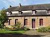 | |
| Ensemble of the tower and the portico of Saint-Quentin church, the parsonage and their environment (nl) (fr) |
Péruwelz | 50°30′25″N 3°35′22″E / 50.507073°N 3.589374°E |
57064-CLT-0006-01 Info |
 | ||
| Verte Chasse drive (nl) (fr) |
Péruwelz | 50°30′24″N 3°35′34″E / 50.506767°N 3.592675°E |
57064-CLT-0007-01 Info |
 | ||
| Church of Saint-Gery (nl) (fr) |
Péruwelz | 50°31′45″N 3°35′14″E / 50.529163°N 3.587203°E |
57064-CLT-0010-01 Info |
 | ||
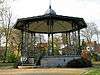
| Music kiosk in the municipal park (nl) (fr) |
Péruwelz | 50°30′31″N 3°35′35″E / 50.508561°N 3.593045°E |
57064-CLT-0011-01 Info |
 | ||
| House "Pavot" and the ensemble of the house and its surroundings (nl) (fr) |
Péruwelz | rue Astrid n°11 | 50°30′41″N 3°35′33″E / 50.511481°N 3.592582°E |
57064-CLT-0012-01 Info |
||
| station (nl) (fr) |
Péruwelz | rue des Français | 50°30′49″N 3°35′30″E / 50.513500°N 3.591793°E |
57064-CLT-0013-01 Info |
||
| Castle "Roseraie" park (nl) (fr) |
Péruwelz | 50°30′20″N 3°35′29″E / 50.505550°N 3.591396°E |
57064-CLT-0014-01 Info |
|||
| Roland House: façades and roofs (nl) (fr) |
Péruwelz | rue Albert Ier n°20 | 50°30′32″N 3°35′29″E / 50.509013°N 3.591517°E |
57064-CLT-0015-01 Info |
||
| House: walls and roofs (nl) (fr) |
Péruwelz | Grand-Place n°38 | 50°30′36″N 3°35′32″E / 50.510120°N 3.592291°E |
57064-CLT-0016-01 Info |
||
| Old washing place "bassin Dubuisson" in the municipal park (nl) (fr) |
Péruwelz | 50°30′30″N 3°35′29″E / 50.508313°N 3.591361°E |
57064-CLT-0017-01 Info |
.jpg) | ||
| House called "Petit Château": facades and roofs (nl) (fr) |
Péruwelz | rue Albert Ier, n°56 | 50°30′29″N 3°35′25″E / 50.508145°N 3.590403°E |
57064-CLT-0018-01 Info |
||
| Castle of Fontenelle: facades, roofs and outbuildings, including the environment and access bridge (nl) (fr) |
Péruwelz | rue du Coron, n°6 (S) | 50°32′24″N 3°32′38″E / 50.539968°N 3.543823°E |
57064-CLT-0019-01 Info |
||
| Basilica Notre-Dame-de-Bon-Secours (nl) (fr) |
Péruwelz | place Jean Absil n°3 | 50°29′50″N 3°36′26″E / 50.497295°N 3.607275°E |
57064-CLT-0021-01 Info |
.JPG) |
See also
| Wikimedia Commons has media related to Cultural heritage monuments in Péruwelz. |
References
- Belgian heritage register: Direction générale opérationnelle - Aménagement du territoire, Logement, Patrimoine et Energie (DG4)
- www.dglive.be
This article is issued from
Wikipedia.
The text is licensed under Creative Commons - Attribution - Sharealike.
Additional terms may apply for the media files.