List of protected heritage sites in Namur (city)
This table shows an overview of the protected heritage sites in the Walloon town Namur, or Namur (city). This list is part of Belgium's national heritage.
| Object |
Year/architect |
Town/section |
Address |
Coordinates |
Number? |
Image |
|---|---|---|---|---|---|---|
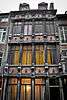
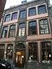
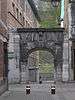
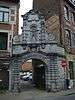
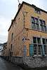
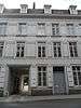
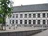
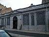
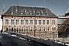
| Old mansion Gaiffier d'Hestroy (nl) (fr) |
Namur | Rue de Fer n° 24 | 50°27′56″N 4°51′55″E / 50.465572°N 4.865390°E |
92094-CLT-0001-01 Info |
.JPG) | |
| Rectory of the parish of Saint-Loup (nl) (fr) |
Namur | Rue du Collège, n° 17 | 50°27′49″N 4°51′48″E / 50.463641°N 4.863306°E |
92094-CLT-0002-01 Info |
 | |
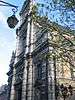
| Church of Saint-Loup (nl) (fr) |
Namur | Rue du Collège | 50°27′50″N 4°51′48″E / 50.464013°N 4.863264°E |
92094-CLT-0003-01 Info |
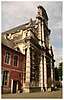 | |
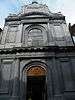
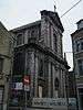
| Church of Saint Joseph (nl) (fr) |
Namur | Rue de Fer | 50°27′57″N 4°51′53″E / 50.465715°N 4.864588°E |
92094-CLT-0004-01 Info |
.JPG) | |
| Pump at the vegetable market ("Marche aux legumes) (nl) (fr) |
Namur | 50°27′48″N 4°51′54″E / 50.463254°N 4.864897°E |
92094-CLT-0005-01 Info |
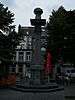 | ||
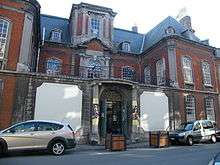
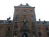
| Old Bishop's Palace, now Provincial Government (nl) (fr) |
Namur | 50°27′51″N 4°51′41″E / 50.464125°N 4.861380°E |
92094-CLT-0006-01 Info |
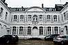 | ||
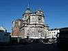
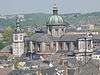
| St Aubin's Cathedral (nl) (fr) |
Namur | 50°27′52″N 4°51′36″E / 50.464551°N 4.859966°E |
92094-CLT-0007-01 Info |
 | ||
| Gate of the Sambre and Meuse rivers (nl) (fr) |
Namur | Rue du Pont | 50°27′44″N 4°52′07″E / 50.462203°N 4.868702°E |
92094-CLT-0008-01 Info |
 | |
| Pump on the Angel market square (nl) (fr) |
1791 François-Joseph Denis | Namur | Place de l'Ange (Angel Quare) | 50°27′51″N 4°51′55″E / 50.464230°N 4.865313°E |
92094-CLT-0009-01 Info |
 |
| Atheneum and school of the 4th degree, or Jesuit college (nl) (fr) |
Namur | Rue du Collège n°s 2-8 | 50°27′50″N 4°51′45″E / 50.463993°N 4.862572°E |
92094-CLT-0010-01 Info |
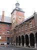 | |
| Belfry of Namur (nl) (fr) |
Namur | 50°27′50″N 4°52′01″E / 50.463825°N 4.867079°E |
92094-CLT-0011-01 Info |
 | ||
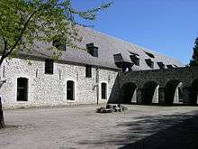
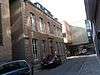
| Archaeological Museum, old butcher shop and meat market (nl) (fr) |
Namur | Rue du Pont | 50°27′44″N 4°52′05″E / 50.462185°N 4.868096°E |
92094-CLT-0012-01 Info |
 | |
| Bishop's Palace, site of the old refuge of the Abbey of Malonne (nl) (fr) |
Namur | Rue de l'Évêché, n° 1 | 50°27′47″N 4°51′34″E / 50.463193°N 4.859530°E |
92094-CLT-0013-01 Info |
||
| Museum de Croix, the old House of Groesbeeck Croix or the Marquis de Croix (nl) (fr) |
Namur | Rue Joseph Saintraint, n° 3 | 50°27′48″N 4°51′40″E / 50.463343°N 4.861217°E |
92094-CLT-0014-01 Info |
 | |
| House facade and roof (nl) (fr) |
Namur | Rue du Collège, n° 41 | 50°27′49″N 4°51′43″E / 50.463738°N 4.861986°E |
92094-CLT-0015-01 Info |
 | |
| Facades and roofs of the building (nl) (fr) |
Namur | Rue du Collège n° 33 | 50°27′49″N 4°51′45″E / 50.463651°N 4.862509°E |
92094-CLT-0016-01 Info |
 | |
| House: Gothic facade (nl) (fr) |
Namur | Rue des Brasseurs n° 107 | 50°27′43″N 4°51′49″E / 50.461984°N 4.863674°E |
92094-CLT-0024-01 Info |
 | |
| House facade (nl) (fr) |
Namur | Rue des Brasseurs n° 109 | 50°27′43″N 4°51′49″E / 50.462004°N 4.863530°E |
92094-CLT-0025-01 Info |
 | |
| House (nl) (fr) |
Namur | Rue des Brasseurs n°s 171-173 | 50°27′44″N 4°51′42″E / 50.462217°N 4.861793°E |
92094-CLT-0027-01 Info |
||
| House (nl) (fr) |
Namur | Rue des Brasseurs n° 175 | 50°27′44″N 4°51′42″E / 50.462240°N 4.861640°E |
92094-CLT-0028-01 Info |
||
| House (nl) (fr) |
Namur | Rue des Brasseurs n° 183 | 50°27′44″N 4°51′40″E / 50.462359°N 4.861147°E |
92094-CLT-0029-01 Info |
 | |
| House: walls and roofs (nl) (fr) |
Namur | Rue du Collège n° 31 | 50°27′49″N 4°51′45″E / 50.463642°N 4.862638°E |
92094-CLT-0034-01 Info |
 | |
| House: walls and roofs (nl) (fr) |
Namur | Rue du Collège n° 35 | 50°27′49″N 4°51′44″E / 50.463659°N 4.862355°E |
92094-CLT-0036-01 Info |
 | |
| Marie-Louise Park (nl) (fr) |
Namur | 50°28′00″N 4°51′17″E / 50.466723°N 4.854768°E |
92094-CLT-0037-01 Info |
 | ||
| House facade (nl) (fr) |
Namur | Rue de Bruxelles n° 57 | 50°27′57″N 4°51′41″E / 50.465797°N 4.861299°E |
92094-CLT-0043-01 Info |
 | |
| Ensemble of the park de la Plante (nl) (fr) |
Namur | 50°27′02″N 4°51′34″E / 50.450681°N 4.859325°E |
92094-CLT-0053-01 Info |
|||
| Fruit Market (nl) (fr) |
Namur | 50°27′48″N 4°51′53″E / 50.463428°N 4.864641°E |
92094-CLT-0054-01 Info |
 | ||
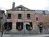
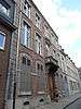
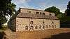
| Hospice Saint-Gilles (nl) (fr) |
Namur | Rue Notre-Dame n° 1 | 50°27′39″N 4°52′05″E / 50.460718°N 4.868055°E |
92094-CLT-0059-01 Info |
.jpg) | |
| Church of Saint-Jean Baptiste (nl) (fr) |
Namur | 50°27′48″N 4°51′55″E / 50.463222°N 4.865375°E |
92094-CLT-0061-01 Info |
 | ||
| Academy of Fine Arts, former Mont-de-Pieté (nl) (fr) |
Namur | Rue du Lombard n°s 12-20 | 50°27′52″N 4°52′13″E / 50.464482°N 4.870397°E |
92094-CLT-0062-01 Info |
 | |
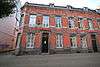
| Tower Marie Spilar (nl) (fr) |
Namur | Rue de la Tour, n° 7 | 50°27′48″N 4°52′06″E / 50.463383°N 4.868408°E |
92094-CLT-0063-01 Info |
.JPG) | |
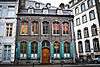
| Tower called "Baduelle" or "de la Monnaie" and a part of the ramparts of the 14th century "third fortified wall" (nl) (fr) |
Namur | Rue Basse-Marcelle 16, tegenwoordig aan de kan van n° 10 | 50°27′54″N 4°51′44″E / 50.464906°N 4.862331°E |
92094-CLT-0064-01 Info |
.jpg) | |
| House (nl) (fr) |
Namur | Rue des Brasseurs n° 169 | 50°27′44″N 4°51′43″E / 50.462198°N 4.861864°E |
92094-CLT-0066-01 Info |
 | |
| Gate on the rue des Brasseurs, on the side of the rue du President, called "Porte de Sambre" (nl) (fr) |
Namur | 50°27′43″N 4°51′50″E / 50.462006°N 4.863763°E |
92094-CLT-0067-01 Info |
 | ||
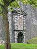
| Citadel: gate of Bordial: Main building and tunnel (nl) (fr) |
Namur | 50°27′40″N 4°51′41″E / 50.461198°N 4.861359°E |
92094-CLT-0068-01 Info |
|||
| Citadel: portal Bordial (nl) (fr) |
Namur | 50°27′40″N 4°51′40″E / 50.461232°N 4.861017°E |
92094-CLT-0069-01 Info |
 | ||
| Church of Saint-Jacques (nl) (fr) |
Namur | 50°27′55″N 4°51′51″E / 50.465257°N 4.864135°E |
92094-CLT-0071-01 Info |
 | ||
| Old mansion Propper (nl) (fr) |
Namur | Rue Joseph Saintraint, n° 1 | 50°27′49″N 4°51′40″E / 50.463714°N 4.861139°E |
92094-CLT-0073-01 Info |
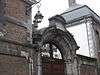 | |
| Gate of the Refuge of the ancient abbey of Floreffe (nl) (fr) |
Namur | Rue de Gravière n° 2 | 50°27′47″N 4°52′11″E / 50.463185°N 4.869611°E |
92094-CLT-0074-01 Info |
 | |
| l'Arsenal (nl) (fr) |
Namur | Rue de l'Arsenal n° 7 | 50°27′51″N 4°51′27″E / 50.464202°N 4.857432°E |
92094-CLT-0075-01 Info |
 | |
| House (nl) (fr) |
Namur | Rue des Brasseurs n° 135 | 50°27′43″N 4°51′46″E / 50.462050°N 4.862673°E |
92094-CLT-0076-01 Info |
 | |
| House (nl) (fr) |
Namur | Rue Lelièvre n° 2 | 50°27′53″N 4°51′40″E / 50.464586°N 4.861188°E |
92094-CLT-0077-01 Info |
 | |
| Citadel: Fort Orange (nl) (fr) |
Namur | 50°27′31″N 4°51′03″E / 50.458561°N 4.850731°E |
92094-CLT-0078-01 Info |
|||
| House: gable roof and front (nl) (fr) |
Namur | rue du Pont n°s 7-9 | 50°27′45″N 4°52′04″E / 50.462544°N 4.867786°E |
92094-CLT-0079-01 Info |
||
| Urban site of the rue des Brasseurs (nl) (fr) |
Namur | rue des Brasseurs | 50°27′44″N 4°51′39″E / 50.462222°N 4.860940°E |
92094-CLT-0080-01 Info |
 | |
| Church of Notre Dame (nl) (fr) |
Namur | 50°27′49″N 4°52′17″E / 50.463532°N 4.871279°E |
92094-CLT-0081-01 Info |
 | ||
| Building (nl) (fr) |
Namur | rue des Brasseurs n° 170 | 50°27′44″N 4°51′44″E / 50.462258°N 4.862170°E |
92094-CLT-0083-01 Info |
||
| Hospice d'Harscamp (south wing parallel to the Meuse) and the ensemble formed by the various buildings and gardens (nl) (fr) |
Namur | rue Saint-Nicolas n° 2 | 50°27′47″N 4°52′17″E / 50.463034°N 4.871439°E |
92094-CLT-0085-01 Info |
||
| House (nl) (fr) |
Namur | rue des Brasseurs n°s 172-174 | 50°27′44″N 4°51′43″E / 50.462278°N 4.862007°E |
92094-CLT-0086-01 Info |
 | |
| House (nl) (fr) |
Namur | rue des Brasseurs n° 176 | 50°27′44″N 4°51′43″E / 50.462306°N 4.861874°E |
92094-CLT-0087-01 Info |
 | |
| House facade and roof (nl) (fr) |
Namur | Rue Lelièvre n° 24 | 50°27′56″N 4°51′40″E / 50.465521°N 4.861233°E |
92094-CLT-0088-01 Info |
 | |
| House on the corner of rue de l'Evêché streets and rue du Seminaire (nl) (fr) |
Namur | 50°27′49″N 4°51′33″E / 50.463703°N 4.859231°E |
92094-CLT-0089-01 Info |
 | ||
| Building (nl) (fr) |
Namur | Rue Grandgagnage n° 7 | 50°27′59″N 4°51′30″E / 50.466449°N 4.858390°E |
92094-CLT-0090-01 Info |
 | |
| Building (nl) (fr) |
Namur | rue Grandgagnage n° 4 | 50°28′01″N 4°51′31″E / 50.466932°N 4.858638°E |
92094-CLT-0091-01 Info |
 | |
| Building called "Café Parisien": facades and roofs, on the corner of the streets rue Cuvelier and rue Pepin (nl) (fr) |
Namur | 50°27′52″N 4°52′00″E / 50.464530°N 4.866682°E |
92094-CLT-0092-01 Info |
|||
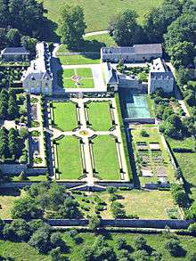
| Ensemble of the David de Lossy castle and surrounding area (nl) (fr) |
Namur | 50°27′52″N 4°48′11″E / 50.464472°N 4.802948°E |
92094-CLT-0093-01 Info |
 | ||
| Farm Notre-Dame au Bois (nl) (fr) |
Namur | 50°26′20″N 4°50′07″E / 50.438878°N 4.835317°E |
92094-CLT-0094-01 Info |
|||
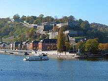
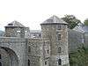
| Citadel of Namur (nl) (fr) |
Namur | 50°27′26″N 4°51′10″E / 50.457316°N 4.852648°E |
92094-CLT-0105-01 Info |
 | ||
| Facades and roofs of the house and the staircase tower and the totality of the entrance portal to the left of the house (nl) (fr) |
Namur | rue du Lombard n°22, Namur | 50°27′53″N 4°52′15″E / 50.464773°N 4.870799°E |
92094-CLT-0106-01 Info |
||
| Old house of Tanners, on the corner of Place l'Ilon (nl) (fr) |
Namur | Saint-Nicolas n°1, Namur | 50°27′49″N 4°52′16″E / 50.463702°N 4.870986°E |
92094-CLT-0107-01 Info |
 | |
| Totality of the hôtel de Wasseige (nl) (fr) |
Namur | rue de Bruxelles n°55 en 55b | 50°27′56″N 4°51′42″E / 50.465663°N 4.861537°E |
92094-CLT-0108-01 Info |
 | |
| The areas with views (nl) (fr) |
Namur | Bouge | 50°28′15″N 4°53′14″E / 50.470835°N 4.887187°E |
92094-CLT-0110-01 Info |
||
| The pourprise (walled enclosure), the gutter and the troughs of an old well in the old converterie of Daussoulx and the ensemble of all existing buildings of the former convertere cited above, with its land, including the driveway of the Abbey. (nl) (fr) |
Namur | 50°30′56″N 4°52′27″E / 50.515434°N 4.874174°E |
92094-CLT-0111-01 Info |
|||
| St. Martin's Church and cemetery (nl) (fr) |
Namur | Dave | 50°24′55″N 4°53′08″E / 50.415309°N 4.885551°E |
92094-CLT-0112-01 Info |
||
| Rectory (nl) (fr) |
Namur | Dave | 50°24′55″N 4°53′14″E / 50.415193°N 4.887104°E |
92094-CLT-0113-01 Info |
||
| Lime tree located at the entrance of the hedge of the "pauvres à Dave" (nl) (fr) |
Namur | 50°24′57″N 4°53′45″E / 50.415746°N 4.895850°E |
92094-CLT-0114-01 Info |
|||
| Ensemble of the castle and its park (nl) (fr) |
Namur | Dave | 50°24′24″N 4°53′03″E / 50.406776°N 4.884243°E |
92094-CLT-0115-01 Info |
 | |
| Chapel of Notre-Dame de Bon Secours, and the ensemble of the chapel and the surrounding area (nl) (fr) |
Namur | Dave | 50°25′14″N 4°53′01″E / 50.420580°N 4.883672°E |
92094-CLT-0116-01 Info |
||
| Church of Notre Dame (nl) (fr) |
Namur | Gelbressée | 50°30′35″N 4°57′16″E / 50.509634°N 4.954542°E |
92094-CLT-0117-01 Info |
||
| Ensemble of the church of Notre Dame Gelbressée and surrounding areas (nl) (fr) |
Namur | 50°30′35″N 4°57′14″E / 50.509651°N 4.953941°E |
92094-CLT-0118-01 Info |
|||
| The keep in Anhaive called "Enhaive" (nl) (fr) |
Namur | 50°27′45″N 4°53′19″E / 50.462594°N 4.888637°E |
92094-CLT-0119-01 Info |
 | ||
| Church of Saint-Quentin (nl) (fr) |
Namur | Lives | 50°27′56″N 4°55′27″E / 50.465598°N 4.924251°E |
92094-CLT-0121-01 Info |
 | |
| Rectory at the church of Saint-Quentin (nl) (fr) |
Namur | Lives-sur-Meuse | 50°27′56″N 4°55′26″E / 50.465492°N 4.923963°E |
92094-CLT-0122-01 Info |
||
| Rocks of Roche à l'Argent (nl) (fr) |
Namur | Lives-sur-Meuse | 50°27′48″N 4°55′37″E / 50.463318°N 4.927014°E |
92094-CLT-0123-01 Info |
 | |
| Expansion of the rocks of Roche à l'Argent, classified by January 13, 1977 (nl) (fr) |
Namur | Lives-sur-Meuse | 50°27′48″N 4°55′37″E / 50.463318°N 4.927014°E |
92094-CLT-0124-01 Info |
||
| Walls of the garden of the rectory and the walls of the cemetery, and the ensemble of the church, the presbytery, garden, outbuildings and cemetery (nl) (fr) |
Namur | 50°27′55″N 4°55′25″E / 50.465413°N 4.923502°E |
92094-CLT-0127-01 Info |
|||
| Parish church of Saint Berthuin (nl) (fr) |
Namur | Malonne | 50°26′12″N 4°47′43″E / 50.436655°N 4.795328°E |
92094-CLT-0128-01 Info |
||
| Old quarry of volcanic rock located in the hamlet of Piroy (nl) (fr) |
Namur | Malonne | 50°24′59″N 4°47′26″E / 50.416432°N 4.790563°E |
92094-CLT-0129-01 Info |
||
| Site of the Rochers de Marche-les-Dames (nl) (fr) |
Namur | 50°28′41″N 4°56′10″E / 50.478191°N 4.936027°E |
92094-CLT-0130-01 Info |
 | ||
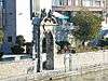
| The walls, the altar, the cross and plaque are located on the site of Marche-les-Dames, geclassficeerd commissioned on December 30, 1933 (nl) (fr) |
Namur | 50°28′54″N 4°56′55″E / 50.481743°N 4.948590°E |
92094-CLT-0131-01 Info |
|||
| Buildings and wall works of the abbey of Vivier, except the later constructions at the end of the 18th century (nl) (fr) |
Namur | Marche-les-Dames | 50°29′20″N 4°57′24″E / 50.489020°N 4.956770°E |
92094-CLT-0133-01 Info |
||
| Chapel of Hastimoulin (nl) (fr) |
Namur | Saint-Servais | 50°28′23″N 4°51′29″E / 50.473164°N 4.858074°E |
92094-CLT-0134-01 Info |
||
| The three old parts: tower, choir and transept of the church of Saint-Hilaire (nl) (fr) |
Namur | Temploux | 50°28′59″N 4°45′03″E / 50.483017°N 4.750872°E |
92094-CLT-0135-01 Info |
||
| Old Church of Saint-Martin (nl) (fr) |
Namur | 50°29′49″N 4°51′51″E / 50.496992°N 4.864181°E |
92094-CLT-0136-01 Info |
|||
| Ensemble of the Calvary of Frizet and the trees around it (nl) (fr) |
Namur | 50°29′52″N 4°52′01″E / 50.497890°N 4.866963°E |
92094-CLT-0137-01 Info |
|||
| Church of Notre-Dame du Rosaire (nl) (fr) |
Namur | 50°25′31″N 4°57′01″E / 50.425364°N 4.950368°E |
92094-CLT-0138-01 Info |
 | ||
| Facades and roofs, and interior with four original fireplaces in blue stone of the old farmhouse Ahhaive, facades and roofs of the old barn and the surrounding walls and the ensemble of these buildings and surrounding area (nl) (fr) |
Namur | Jambes | 50°27′44″N 4°53′21″E / 50.462267°N 4.889152°E |
92094-CLT-0139-01 Info |
||
| Facades and roofs of the ensemble at the corner of rue Grandgagnage No. 2 A and 2 B and the n ° 71 rue de Bruxelles (nl) (fr) |
Namur | 50°28′01″N 4°51′32″E / 50.467034°N 4.858892°E |
92094-CLT-0141-01 Info |
 | ||
| Street facades and roofs of the building (nl) (fr) |
Namur | rue de l'Ouvrage n°1 | 50°27′52″N 4°51′48″E / 50.464551°N 4.863316°E |
92094-CLT-0142-01 Info |
||
| Facades and roofs of the building (nl) (fr) |
Namur | rue Saint-Nicolas n°59 | 50°27′51″N 4°52′19″E / 50.464220°N 4.871951°E |
92094-CLT-0143-01 Info |
 | |
| Castle Farm and adjoining chapel of Saint Apolline Wartet and the ensemble of the farm and its surroundings (nl) (fr) |
Namur | 50°29′29″N 4°58′17″E / 50.491344°N 4.971506°E |
92094-CLT-0144-01 Info |
|||
| Facades and roofs of the building (nl) (fr) |
Namur | Boulevard de la Meuse n°78 (voorheen 66), Jambes | 50°27′11″N 4°51′47″E / 50.452954°N 4.862960°E |
92094-CLT-0147-01 Info |
||
| Chapel of Saint-Sacrament (nl) (fr) |
Namur | Frizet | 50°29′47″N 4°51′48″E / 50.496515°N 4.863243°E |
92094-CLT-0148-01 Info |
||
| Old abandoned street in Marlagne: chapel of Sainte-Marie-Madeleine, bakery, gate and surrounding walls, Chemin des Carmes and the ensemble of these buildings and their surroundings (nl) (fr) |
Namur | 50°25′20″N 4°51′06″E / 50.422188°N 4.851690°E |
92094-CLT-0149-01 Info |
|||
| Bridge of Jambes and the ensemble of the bridge and the surrounding area, where both banks of the Meuse river and the adjacent roads are aligned (nl) (fr) |
Namur | 50°27′30″N 4°51′58″E / 50.458314°N 4.866036°E |
92094-CLT-0150-01 Info |
 | ||
| L'île de Dave (nl) (fr) |
Namur | 50°25′20″N 4°52′46″E / 50.422228°N 4.879340°E |
92094-CLT-0152-01 Info |
 | ||
| Facades and roofs of the pentagon formed by the buildings of the farm Ponty and the ensemble of the farm and surrounding areas (nl) (fr) |
Namur | chaussé de Louvain n°429, Bouge | 50°29′15″N 4°53′28″E / 50.487408°N 4.891140°E |
92094-CLT-0153-01 Info |
.jpg) | |
| Center of the village of Bouge (nl) (fr) |
Namur | Bouge | 50°28′23″N 4°53′22″E / 50.473131°N 4.889440°E |
92094-CLT-0154-01 Info |
||
| Totality of the chapel of Sainte-Wivinne and the ensemble of the chapel and the land on which it stands, including the lime tree (nl) (fr) |
Namur | Temploux | 50°29′01″N 4°44′46″E / 50.483746°N 4.746130°E |
92094-CLT-0156-01 Info |
||
| The entire wing of the former convent of the Celestines (nl) (fr) |
Namur | rue du Lombard 79, Namur | 50°27′57″N 4°52′14″E / 50.465820°N 4.870658°E |
92094-CLT-0157-01 Info |
 | |
| Facades and roofs of the house of Pierre du Diable (nl) (fr) |
Namur | rue de Dave n° 404, Jambes | 50°26′39″N 4°52′02″E / 50.444074°N 4.867196°E |
92094-CLT-0158-01 Info |
||
| Facades and roofs (including wings) of the judiciary Palace (nl) (fr) |
Namur | 50°27′54″N 4°51′34″E / 50.465117°N 4.859528°E |
92094-CLT-0159-01 Info |
 | ||
| Facades and roofs of the castle and the ensemble of the building and surrounding areas (nl) (fr) |
Namur | Loyers | 50°27′52″N 4°56′55″E / 50.464386°N 4.948504°E |
92094-CLT-0160-01 Info |
||
| Grasslands situated opposite the island of Dave and the castle park Wasseige (nl) (fr) |
Namur | 50°24′57″N 4°53′05″E / 50.415957°N 4.884829°E |
92094-CLT-0161-01 Info |
|||
| The classified site on the island of Dave is extended to the downstream edge of the island situated on the one hand, and the non-navigable arm of the river and its banks on the other (nl) (fr) |
Namur | 50°25′20″N 4°52′46″E / 50.422228°N 4.879340°E |
92094-CLT-0162-01 Info |
|||
| Forest Coquelet (nl) (fr) |
Namur | Bouge | 50°28′07″N 4°52′48″E / 50.468501°N 4.880060°E |
92094-CLT-0164-01 Info |
||
| Facades, roofs and surrounding wall of the presbytery (nl) (fr) |
Namur | rue Fond du village, Wierde | 50°25′31″N 4°57′04″E / 50.425363°N 4.950982°E |
92094-CLT-0166-01 Info |
 | |
| Facades and roofs of the ensemble of buildings and the surrounding wall of the farmhouse on the rue Jausse 139, the landscape surrounding the site of the village and monuments including the retaining walls along the roads and buildings along the street, rue de Jausse n ° s 152, 154, 156, 168, 178, 182, 188, 179, and the small chapel, and the street rue du Fond du Village n ° s 31, 32 and 33, and establishment of a protection zone at the edge of the architectural ensemble (nl) (fr) |
Namur | rue de Jausse 139, Wierde | 50°25′29″N 4°56′46″E / 50.424636°N 4.946182°E |
92094-CLT-0167-01 Info |
 | |
| The woods near the castle of Loyers (nl) (fr) |
Namur | 50°27′59″N 4°56′46″E / 50.466273°N 4.946145°E |
92094-CLT-0169-01 Info |
 | ||
| Farm and small outbuildings opposite and the ensemble of buildings and surrounding area (nl) (fr) |
Namur | 50°26′38″N 4°47′50″E / 50.444006°N 4.797116°E |
92094-CLT-0171-01 Info |
|||
| The abribus (nl) (fr) |
Namur | avenue de la Plante, tegenover het park, Namur | 50°27′10″N 4°51′38″E / 50.452744°N 4.860605°E |
92094-CLT-0172-01 Info |
||
| The street facades and roof pitches in the streets of the building "Bibot" (nl) (fr) |
Namur | place Léopold, Namur | 50°28′06″N 4°52′04″E / 50.468227°N 4.867894°E |
92094-CLT-0174-01 Info |
 | |
| Building (nl) (fr) |
Namur | avenue Jean Materne n°82 en 84, Jambes | 50°27′26″N 4°52′11″E / 50.457285°N 4.869790°E |
92094-CLT-0175-01 Info |
||
| The facades and roofs of houses located in the Avenue de la Pair Elle, and the ensemble of these houses, the chapel of Notre-Dame de Lorette and the annex on the corner of rue Dohet (nl) (fr) |
Namur | avenue de la Pairelle n°s 44 en 45, Namur | 50°26′29″N 4°51′33″E / 50.441465°N 4.859284°E |
92094-CLT-0176-01 Info |
||
| Théâtre Royal de Namur, because the main facade, side facade, including the roof and the interior up to the iron curtain (nl) (fr) |
Namur | 50°27′52″N 4°52′05″E / 50.464383°N 4.868150°E |
92094-CLT-0177-01 Info |
 | ||
| Facades and roofs of the house, including a garden pavilion with cast iron railings and stairs in the style of Louis XV (nl) (fr) |
Namur | rue des Brasseurs n°5 | 50°27′44″N 4°52′02″E / 50.462203°N 4.867237°E |
92094-CLT-0178-01 Info |
 | |
| Ensemble of the facades and roofs, and certain elements of the inteireur of the building (nl) (fr) |
Namur | 50°27′47″N 4°51′52″E / 50.463141°N 4.864467°E |
92094-CLT-0187-01 Info |
|||
| Island Vas-t'y-frotte à la Plante (nl) (fr) |
Namur | 50°26′37″N 4°51′35″E / 50.443622°N 4.859747°E |
92094-CLT-0188-01 Info |
 | ||
| The old mill of Beez (nl) (fr) |
Namur | Beez | 50°27′56″N 4°54′26″E / 50.465518°N 4.907285°E |
92094-CLT-0190-01 Info |
||
| Ensemble of the land, pastures and farms of the plateau of Berlacomine (nl) (fr) |
Namur | Vedrin | 50°29′02″N 4°51′25″E / 50.483865°N 4.856984°E |
92094-CLT-0192-01 Info |
 | |
| Certain parts of the citadel of Namur (nl) (fr) |
Namur | 50°27′34″N 4°51′52″E / 50.459508°N 4.864356°E |
92094-CLT-0195-01 Info |
 | ||
| Ensemble of the building "Patria", with the exception of the restaurant on the ground floor, kitchen, bathrooms, porch and the backyard (nl) (fr) |
Namur | Saint-Aubain n°3, Namur | 50°27′50″N 4°51′38″E / 50.463905°N 4.860446°E |
92094-CLT-0196-01 Info |
 | |
| Facade and roof of the house (nl) (fr) |
Namur | rue des Brasseurs n°7 | 50°27′44″N 4°52′02″E / 50.462198°N 4.867125°E |
92094-CLT-0197-01 Info |
||
| Plaster of the hôtel d'Gaiffier Hestroy (nl) (fr) |
Namur | 50°27′56″N 4°51′55″E / 50.465572°N 4.865390°E |
92094-PEX-0001-01 Info |
 | ||
| Ensemble of the church of Saint-Loup, except the organ (instrumental part and buffet) (nl) (fr) |
Namur | 50°27′50″N 4°51′48″E / 50.464013°N 4.863264°E |
92094-PEX-0002-01 Info |
 | ||
| Ensemble of the Cathedral Saint-Aubin, with the exception of the choir organ and the instrumental part of the organ-gallery (nl) (fr) |
Namur | 50°27′52″N 4°51′36″E / 50.464551°N 4.859966°E |
92094-PEX-0003-01 Info |
 | ||
| Belfry of Namur (nl) (fr) |
Namur | 50°27′50″N 4°52′01″E / 50.463825°N 4.867079°E |
92094-PEX-0004-01 Info |
 | ||
| Old fleshers hall (meat market) (nl) (fr) |
Namur | 50°27′44″N 4°52′05″E / 50.462185°N 4.868096°E |
92094-PEX-0005-01 Info |
 | ||
| Old hotel Groesbeeck de Croix (nl) (fr) |
Namur | 50°27′48″N 4°51′40″E / 50.463343°N 4.861217°E |
92094-PEX-0006-01 Info |
|||
| Bordial door of the citadel (nl) (fr) |
Namur | 50°27′40″N 4°51′40″E / 50.461232°N 4.861017°E |
92094-PEX-0007-01 Info |
|||
| L'Arsenal (nl) (fr) |
Namur | 50°27′51″N 4°51′27″E / 50.464202°N 4.857432°E |
92094-PEX-0008-01 Info |
|||
| Fort Orange from the citadel (nl) (fr) |
Namur | 50°27′31″N 4°51′03″E / 50.458561°N 4.850731°E |
92094-PEX-0009-01 Info |
|||
| Ensemble of the church of Notre-Dame, except the organ (nl) (fr) |
Namur | 50°27′49″N 4°52′17″E / 50.463532°N 4.871279°E |
92094-PEX-0010-01 Info |
|||
| Citadel of Namur (nl) (fr) |
Namur | 50°27′26″N 4°51′10″E / 50.457316°N 4.852648°E |
92094-PEX-0011-01 Info |
 | ||
| Rocks of Marche-les-Dames (nl) (fr) |
Namur | 50°28′41″N 4°56′10″E / 50.478191°N 4.936027°E |
92094-PEX-0012-01 Info |
|||
| Vivier Abbey: the buildings and walls, with the exception of the later buildings from the late 18th century (nl) (fr) |
Namur | Marche-les-Dames | 50°29′20″N 4°57′24″E / 50.489020°N 4.956770°E |
92094-PEX-0013-01 Info |
||
| Certain parts of the Citadel of Namur (nl) (fr) |
Namur | 50°27′34″N 4°51′52″E / 50.459508°N 4.864356°E |
92094-PEX-0014-01 Info |
 |
See also
| Wikimedia Commons has media related to Cultural heritage monuments in Namur (city). |
References
- Belgian heritage register: Direction générale opérationnelle - Aménagement du territoire, Logement, Patrimoine et Energie (DG4)
- www.dglive.be