List of protected heritage sites in Lontzen
This table shows an overview of the protected heritage sites in the Walloon town Lontzen. This list is part of Belgium's national heritage.
| Object |
Year/architect |
Town/section |
Address |
Coordinates |
Number? |
Image |
|---|---|---|---|---|---|---|
| Belgian-Prussian border marker 187 (nl) (de) |
Lontzen | 50°18′31″N 6°00′47″E / 50.308639°N 6.013061°E |
63048-CLT-0001-01 Info |
|||
| house (nl) (de) |
Lontzen | Kirchstrasse 28 | 50°39′40″N 5°59′01″E / 50.660983°N 5.983744°E |
63048-CLT-0002-01 Info |
 | |
| St. Hubert Church, and 18th century tombstones (nl) (de) |
Lontzen | 50°40′49″N 6°00′31″E / 50.680219°N 6.008514°E |
63048-CLT-0003-01 Info |
 | ||
| St. Stephen's church with rectory and tombstones from the 16th to 18th centuries (nl) (de) |
Lontzen | 50°40′31″N 6°02′46″E / 50.675216°N 6.046055°E |
63048-CLT-0004-01 Info |
.jpg) | ||
| St. Anne Chapel (nl) (de) |
Lontzen | 50°41′02″N 5°59′26″E / 50.683817°N 5.990505°E |
63048-CLT-0005-01 Info |
 | ||
| house (nl) (de) |
Lontzen | Dorfstrasse 44 | 50°40′29″N 6°02′47″E / 50.674626°N 6.046422°E |
63048-CLT-0006-01 Info |
.jpg) | |
| Chapel of St. John the Baptist and surroundings (nl) (de) |
Lontzen | Astenet | 50°41′28″N 6°02′01″E / 50.691102°N 6.033745°E |
63048-CLT-0007-01 Info |
.jpg) | |
| "Weiss Haus" house (nl) (de) |
Lontzen | 50°41′04″N 5°57′19″E / 50.684309°N 5.955161°E |
63048-CLT-0008-01 Info |
.jpg) | ||
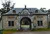
| Castle Thor and surrounding area with park (nl) (de) |
Lontzen | Astenet | 50°41′26″N 6°01′59″E / 50.690468°N 6.033056°E |
63048-CLT-0009-01 Info |
 | |
| house (nl) (de) |
Lontzen | Waldstrasse 11 | 50°41′20″N 5°59′49″E / 50.688753°N 5.996889°E |
63048-CLT-0010-01 Info |
.jpg) | |
| Mützhof house (nl) (de) |
Lontzen | Astenet | 50°41′29″N 6°02′04″E / 50.691299°N 6.034383°E |
63048-CLT-0011-01 Info |
.jpg) | |
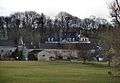
| Castle Lontzen (nl) (de) |
Lontzen | 50°40′47″N 6°00′40″E / 50.679734°N 6.010998°E |
63048-CLT-0012-01 Info |
 | ||
| Backofen Gut bakery (nl) (de) |
Lontzen | Windsweg 21 | 50°41′14″N 5°57′51″E / 50.687093°N 5.964100°E |
63048-CLT-0013-01 Info |
.jpg) | |
| Neuschmiede Barn (nl) (de) |
Lontzen | 50°41′25″N 6°01′55″E / 50.690311°N 6.032054°E |
63048-CLT-0014-01 Info |
.jpg) | ||
| Hof Himmelsplatz complex (nl) (de) |
Lontzen | 50°42′01″N 6°02′06″E / 50.700269°N 6.034913°E |
63048-CLT-0015-01 Info |
.jpg) | ||
| Galmeitrift, or "Pelempelter Büschgen" (nl) (de) |
Lontzen | Rabotrath | 50°40′09″N 6°00′54″E / 50.669114°N 6.015096°E |
63048-CLT-0016-01 Info |
.jpg) | |
| Heesgasse (nl) (de) |
Lontzen | 50°40′35″N 6°00′52″E / 50.676265°N 6.014326°E |
63048-CLT-0017-01 Info |
.jpg) |
See also
| Wikimedia Commons has media related to Cultural heritage monuments in. |
References
- Belgian heritage register: Direction générale opérationnelle - Aménagement du territoire, Logement, Patrimoine et Energie (DG4)
- www.dglive.be
This article is issued from
Wikipedia.
The text is licensed under Creative Commons - Attribution - Sharealike.
Additional terms may apply for the media files.