List of protected heritage sites in Limbourg
This table shows an overview of the protected heritage sites in the Walloon town Limbourg. This list is part of Belgium's national heritage.
| Object |
Year/architect |
Town/section |
Address |
Coordinates |
Number? |
Image |
|---|---|---|---|---|---|---|
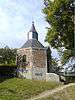
| Chapel of Saint Anne (nl) (fr) |
Limbourg | 50°36′16″N 5°56′05″E / 50.604559°N 5.934824°E |
63046-CLT-0001-01 Info |
 | ||
| Saint Georges Church (nl) (fr) |
Limbourg | 50°36′45″N 5°56′28″E / 50.612636°N 5.941158°E |
63046-CLT-0003-01 Info |
.jpg) | ||
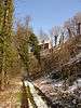
| Old walls or ramparts (nl) (fr) |
Limbourg | 50°36′59″N 5°56′25″E / 50.616478°N 5.940180°E |
63046-CLT-0004-01 Info |
 | ||
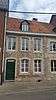
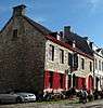
| house (nl) (fr) |
Limbourg | rue Georges Wilson, n°32 | 50°37′15″N 5°56′24″E / 50.620905°N 5.940061°E |
63046-CLT-0005-01 Info |
.jpg) | |
| house (nl) (fr) |
Limbourg | rue Georges Wilson, n°34 | 50°37′15″N 5°56′24″E / 50.620936°N 5.939986°E |
63046-CLT-0006-01 Info |
 | |
| Choir from the 15th century Church of Saint-Roch (nl) (fr) |
Limbourg | 50°37′28″N 5°55′10″E / 50.624398°N 5.919377°E |
63046-CLT-0007-01 Info |
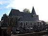 | ||
| Church of Saint-Roch (nl) (fr) |
Limbourg | 50°37′28″N 5°55′10″E / 50.624421°N 5.919506°E |
63046-CLT-0008-01 Info |
| ||
| Church Saint-Lambert (nl) (fr) |
Limbourg | 50°36′24″N 5°57′23″E / 50.606740°N 5.956269°E |
63046-CLT-0010-01 Info |
 | ||
| Public pump (nl) (fr) |
Limbourg | rue Derrière l'église. | 50°36′42″N 5°56′28″E / 50.611600°N 5.941157°E |
63046-CLT-0011-01 Info |
.jpg) | |
| house (nl) (fr) |
Limbourg | place Saint-Georges, n°36 | 50°36′44″N 5°56′24″E / 50.612354°N 5.940067°E |
63046-CLT-0012-01 Info |
.jpg) | |
| Road pavement and curbs (cobblestones) (nl) (fr) |
Limbourg | place Saint-Georges | 50°36′44″N 5°56′25″E / 50.612206°N 5.940330°E |
63046-CLT-0013-01 Info |
.jpg) | |
| The wall around the garden and the gate of the poorhouse "Caldenborg Bardieus" (nl) (fr) |
Limbourg | rue Derrière l'Eglise en gesitueerd aan de achterzijde van het gebouw aan Place Saint-Georges n°31 | 50°36′45″N 5°56′27″E / 50.612484°N 5.940845°E |
63046-CLT-0014-01 Info |
.jpg) | |
| Walled garden (nl) (fr) |
Limbourg | 50°36′45″N 5°56′26″E / 50.612478°N 5.940548°E |
63046-CLT-0015-01 Info |
 | ||
| house (nl) (fr) |
Limbourg | place Saint-Georges n°72 | 50°36′41″N 5°56′24″E / 50.611443°N 5.940127°E |
63046-CLT-0016-01 Info |
.jpg) | |
| house (nl) (fr) |
Limbourg | place Saint-Georges n° 33 | 50°36′45″N 5°56′26″E / 50.612388°N 5.940693°E |
63046-CLT-0017-01 Info |
.jpg) | |
| Former city hall (nl) (fr) |
Limbourg | place Saint-Georges n°30 | 50°36′45″N 5°56′24″E / 50.612524°N 5.940128°E |
63046-CLT-0018-01 Info |
.jpg) | |
| house (nl) (fr) |
Limbourg | Sur les Remparts, n° 124 | 50°36′40″N 5°56′24″E / 50.611113°N 5.939885°E |
63046-CLT-0019-01 Info |
.jpg) | |
| Wall along street and Provost's gate, up to the arms of "Mathias de Amezaga," and the wall perpendicular to the street (nl) (fr) |
Limbourg | rue Derrière l'Eglise | 50°36′47″N 5°56′27″E / 50.613056°N 5.940856°E |
63046-CLT-0020-01 Info |
.jpg) | |
| house (nl) (fr) |
Limbourg | place Saint-Georges n° 42 | 50°36′44″N 5°56′24″E / 50.612158°N 5.940067°E |
63046-CLT-0021-01 Info |
.jpg) | |
| castle of Villers (walls, roof gables) (nl) (fr) |
Limbourg | 50°38′00″N 5°55′21″E / 50.633303°N 5.922401°E |
63046-CLT-0022-01 Info |
.jpg) | ||
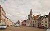
| Haute Ville Limbourg architecture (nl) (fr) |
Limbourg | 50°36′39″N 5°56′23″E / 50.610956°N 5.939786°E |
63046-PEX-0001-01 Info |
 |
See also
| Wikimedia Commons has media related to Cultural heritage monuments in Limbourg. |
References
- Belgian heritage register: Direction générale opérationnelle - Aménagement du territoire, Logement, Patrimoine et Energie (DG4)
- www.dglive.be
This article is issued from
Wikipedia.
The text is licensed under Creative Commons - Attribution - Sharealike.
Additional terms may apply for the media files.