List of protected heritage sites in Eghezée
This table shows an overview of the protected heritage sites in the Walloon town Eghezée. This list is part of Belgium's national heritage.
| Object |
Year/architect |
Town/section |
Address |
Coordinates |
Number? |
Image |
|---|---|---|---|---|---|---|
| Combination of the castle, the farm and surrounding land in Aische-and-Refail (nl) (fr) |
Eghezée | 50°35′46″N 4°49′29″E / 50.596156°N 4.824696°E |
92035-CLT-0001-01 Info |
.JPG) | ||
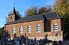
| The church of St. Martin in Harlue (M) and the group formed by the church, the rectory, the castle, the avenue of trees of the bridge over the creek "The Mark" at the entrance of the church and the castle and the surrounding land (nl) (fr) |
Eghezée | 50°36′30″N 4°54′48″E / 50.608471°N 4.913422°E |
92035-CLT-0002-01 Info |
 | ||
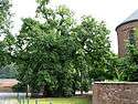
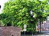
| The old oak tree Liernu (nl) (fr) |
Eghezée | 50°35′03″N 4°49′40″E / 50.584123°N 4.827681°E |
92035-CLT-0003-01 Info |
.jpg) | ||
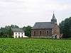
| The tower and nave of the church of Saint-Germain (M) and totality of the church, the cemetery and the surrounding wall (S) (nl) (fr) |
Eghezée | 50°34′22″N 4°50′36″E / 50.572890°N 4.843436°E |
92035-CLT-0004-01 Info |
.JPG) | ||
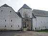
| The facades and roofs of the farm and the paving of the courtyard of the farm Monceau Mehaigne (M) and the group formed by the building and surrounding land (nl) (fr) |
Eghezée | 50°35′29″N 4°52′03″E / 50.591287°N 4.867370°E |
92035-CLT-0006-01 Info |
 | ||
| The whole chapel of the Croix-Monet and the facades and roofs of the house of the chaplain (M) and the ensemble formed by the two buildings and surrounding grounds (S)-and-Aische Refail (nl) (fr) |
Eghezée | 50°35′33″N 4°49′49″E / 50.592509°N 4.830339°E |
92035-CLT-0007-01 Info |
.JPG) | ||
| The ruins of the castle Aische-en-Refail and the farm adjoining the barn in its entirety with the structure, walls and roofs of all buildings on the farm, the old tower of the castle, the surrounding walls, the sides of the castle walls and the access bridge and finally the pair of pillars that mark the entrance, walls and roofs of the small building (a former bakery or smith), which stands on the left front of main gate (nl) (fr) |
Eghezée | 50°35′48″N 4°49′45″E / 50.596594°N 4.829286°E |
92035-CLT-0008-01 Info |
|||
| The whole barn located on the rue du Gros Chene, No 1 Liernu (M) and the group formed by her and the surrounding land (nl) (fr) |
Eghezée | 50°35′00″N 4°49′44″E / 50.583437°N 4.828751°E |
92035-CLT-0010-01 Info |
 | ||
| The facades and roofs of the buildings and the portico of the farmhouse dating from 1806 on the Rue de la Gare, No 21 (nl) (fr) |
Eghezée | 50°37′04″N 4°55′45″E / 50.617779°N 4.929262°E |
92035-CLT-0011-01 Info |
.jpg) | ||
| The facades and roofs of the chapel of St. Peter Franquenée (nl) (fr) |
Taviers Eghezée | 50°37′14″N 4°56′33″E / 50.620614°N 4.942593°E |
92035-CLT-0014-01 Info |
 | ||
| The old oak tree Liernu (nl) (fr) |
Eghezée | 50°35′03″N 4°49′40″E / 50.584123°N 4.827681°E |
92035-PEX-0001-01 Info |
 |
See also
| Wikimedia Commons has media related to Cultural heritage monuments in Eghezée. |
References
- Belgian heritage register: Direction générale opérationnelle - Aménagement du territoire, Logement, Patrimoine et Energie (DG4)
- www.dglive.be
This article is issued from
Wikipedia.
The text is licensed under Creative Commons - Attribution - Sharealike.
Additional terms may apply for the media files.