List of protected heritage sites in Ath
This table shows an overview of the protected heritage sites in the Walloon town Ath. This list is part of Belgium's national heritage.
| Object |
Year/architect |
Town/section |
Address |
Coordinates |
Number? |
Image |
|---|---|---|---|---|---|---|
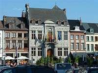
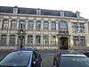
| City Hall (nl) (fr) |
Aat | 50°37′50″N 3°46′37″E / 50.630585°N 3.777075°E |
51004-CLT-0001-01 Info |
 | ||
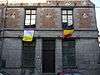
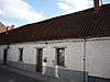
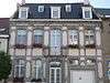
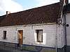
| old house (nl) (fr) |
Aat | rue Haute n° 27 | 50°37′46″N 3°46′48″E / 50.629530°N 3.780126°E |
51004-CLT-0003-01 Info |
 | |
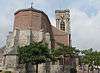
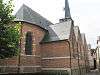
| Church of St. Julien (nl) (fr) |
Aat | 50°37′44″N 3°46′32″E / 50.629011°N 3.775421°E |
51004-CLT-0006-01 Info |
 | ||
| Stations of the Cross in St. Martin's church (nl) (fr) |
Aat | 50°37′56″N 3°46′39″E / 50.632153°N 3.777554°E |
51004-CLT-0007-01 Info |
 | ||
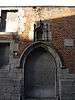
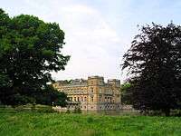
| Castle Burbant (nl) (fr) |
Aat | 50°37′51″N 3°46′29″E / 50.630962°N 3.774602°E |
51004-CLT-0008-01 Info |
 | ||
| St. Martin's church (nl) (fr) |
Aat | 50°37′55″N 3°46′38″E / 50.632012°N 3.777250°E |
51004-CLT-0010-01 Info |
 | ||
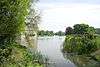
| Bridge and fortifications (nl) (fr) |
Aat | 50°38′01″N 3°46′31″E / 50.633684°N 3.775268°E |
51004-CLT-0011-01 Info |
 | ||
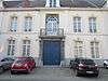
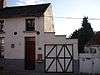
| House of Piety (nl) (fr) |
Aat | rue du Spectacle, Ath | 50°37′42″N 3°46′41″E / 50.628461°N 3.778019°E |
51004-CLT-0014-01 Info |
 | |
| Ruins of Fort du Mont-Féron (nl) (fr) |
Aat | chaussée de Tournai | 50°37′57″N 3°46′03″E / 50.632438°N 3.767430°E |
51004-CLT-0016-01 Info |
||
| Mason's guild hall (nl) (fr) |
Aat | rue de la Fosse n° 45 | 50°37′04″N 3°48′10″E / 50.617702°N 3.802804°E |
51004-CLT-0017-01 Info |
 | |
| Old Brasserie (nl) (fr) |
Aat | rue de la fosse 56 | 50°37′06″N 3°48′07″E / 50.618284°N 3.802011°E |
51004-CLT-0021-01 Info |
||
| Brasserie extension (nl) (fr) |
Aat | rue de la Fosse 56 | 50°37′06″N 3°48′06″E / 50.618380°N 3.801786°E |
51004-CLT-0022-01 Info |
||
| Castle Berliere grounds (nl) (fr) |
Aat | 50°38′59″N 3°41′05″E / 50.649826°N 3.684776°E |
51004-CLT-0026-01 Info |
 | ||
| Castle Berliere (nl) (fr) |
Aat | 50°38′31″N 3°41′35″E / 50.641813°N 3.693131°E |
51004-CLT-0027-01 Info |
 | ||
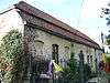
| Fortified house of Irchonwelz (nl) (fr) |
Aat | 50°37′14″N 3°45′29″E / 50.620488°N 3.758033°E |
51004-CLT-0028-01 Info |
.JPG) | ||
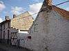
| Irchonwelz grounds (nl) (fr) |
Aat | 50°37′13″N 3°45′20″E / 50.620214°N 3.755512°E |
51004-CLT-0029-01 Info |
.JPG) | ||
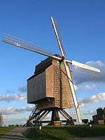
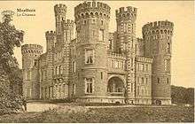
| Moulin de la Marquise (windmill) (nl) (fr) |
1747-1752 | Aat Moulbaix | Moulbaix | 50°35′55″N 3°43′10″E / 50.598503°N 3.719367°E |
51004-CLT-0033-01 Info |
 |
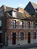
| Old house (nl) (fr) |
Aat | rue du Noir Boeuf n° 3 | 50°37′43″N 3°46′45″E / 50.628630°N 3.779028°E |
51004-CLT-0034-01 Info |
 | |
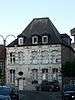
| Brasserie Langie House (nl) (fr) |
Aat | 50°37′56″N 3°46′41″E / 50.632229°N 3.777989°E |
51004-CLT-0036-01 Info |
 | ||
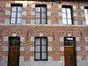
| Old house (nl) (fr) |
Aat | rue Beugnies 2-4 | 50°37′42″N 3°46′44″E / 50.628199°N 3.778797°E |
51004-CLT-0038-01 Info |
 | |
| House (nl) (fr) |
Aat | rue Beugnies 6 | 50°37′42″N 3°46′44″E / 50.628258°N 3.778876°E |
51004-CLT-0039-01 Info |
 | |
| Old house (nl) (fr) |
Aat | rue Beugnies 8 | 50°37′42″N 3°46′44″E / 50.628300°N 3.778872°E |
51004-CLT-0040-01 Info |
 | |
| Site de la Cavée |
Aat | 50°40′37″N 3°48′05″E / 50.676811°N 3.801366°E |
51004-CLT-0041-01 Info |
|||
| House (nl) (fr) |
Aat Moulbaix | 50°36′22″N 3°42′50″E / 50.606089°N 3.713889°E |
51004-CLT-0042-01 Info |
 | ||
| Chapel of Notre-Dame au Chêne (nl) (fr) |
Aat | chaussée de Tournai, links van n°241 | 50°37′40″N 3°44′46″E / 50.627706°N 3.746032°E |
51004-CLT-0043-01 Info |
||
| Castle Bourlu (nl) (fr) |
Aat | 50°37′54″N 3°46′46″E / 50.631544°N 3.779558°E |
51004-CLT-0044-01 Info |
 | ||
| Le Blanc Moulin (windmill) (nl) (fr) |
Aat Ostiches | chemin de la Cocampe, links van n°326 | 50°40′34″N 3°45′46″E / 50.676048°N 3.762809°E |
51004-CLT-0045-01 Info |
 | |
| Calc oven (nl) (fr) |
Aat | 50°36′59″N 3°48′05″E / 50.616302°N 3.801402°E |
51004-CLT-0047-01 Info |
|||
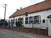
| Old farmhouse (nl) (fr) |
Aat | 50°39′07″N 3°45′12″E / 50.652074°N 3.753235°E |
51004-CLT-0048-01 Info |
 | ||
| Old house (nl) (fr) |
Aat | rue de Scamps, n° 57 et alentours | 50°37′11″N 3°47′24″E / 50.619626°N 3.789917°E |
51004-CLT-0049-01 Info |
 | |
| Castle Francqué (or Castle Coron) (nl) (fr) |
Aat | chaussée de Lessines n° 75 | 50°38′46″N 3°47′50″E / 50.646135°N 3.797256°E |
51004-CLT-0050-01 Info |
||
| Old house (nl) (fr) |
Aat | rue du Pont-Mouchon | 50°37′08″N 3°45′15″E / 50.618798°N 3.754118°E |
51004-CLT-0051-01 Info |
||
| Farmhouse (nl) (fr) |
Aat | rue de l'enfer n° 2 | 50°39′45″N 3°46′55″E / 50.662585°N 3.782025°E |
51004-CLT-0052-01 Info |
||
| Castle Grand Champ (nl) (fr) |
Aat | 50°38′02″N 3°51′24″E / 50.633911°N 3.856711°E |
51004-CLT-0053-01 Info |
|||
| Chapel Notre-Dame du Refuge (nl) (fr) |
Aat | rue du Carnier n° 3 en 5 | 50°38′22″N 3°40′51″E / 50.639370°N 3.680957°E |
51004-CLT-0054-01 Info |
.JPG) | |
| Mason's guild house (nl) (fr) |
Aat | rue de la Fosse n° 47. | 50°37′04″N 3°48′10″E / 50.617770°N 3.802639°E |
51004-CLT-0055-01 Info |
 | |
| Mason's guild house (nl) (fr) |
Aat | rue de la Fosse n° 49. | 50°37′04″N 3°48′09″E / 50.617813°N 3.802538°E |
51004-CLT-0056-01 Info |
 | |
| Mason's guild house (nl) (fr) |
Aat | rue de la Fosse n° 51. | 50°37′04″N 3°48′09″E / 50.617843°N 3.802459°E |
51004-CLT-0057-01 Info |
 | |
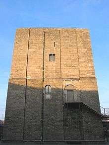
| Tower of Burbant (nl) (fr) |
Aat | 50°37′51″N 3°46′29″E / 50.630962°N 3.774602°E |
51004-PEX-0001-01 Info |
| ||
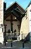
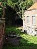
| Mausoleum Oultremont (nl) (fr) |
Aat | 50°38′22″N 3°40′51″E / 50.639370°N 3.680957°E |
51004-PEX-0002-01 Info |
.JPG) |
See also
| Wikimedia Commons has media related to Cultural heritage monuments in Ath. |