List of listed buildings in South Uist
This is a list of listed buildings in the parish of South Uist in the Outer Hebrides, Scotland.
List
| Name | Location | Date Listed | Grid Ref. [note 1] | Geo-coordinates | Notes | HB Number [note 2] | Image |
|---|---|---|---|---|---|---|---|
| South Lochboisdale Boisdale House And Post Office | 57°08′13″N 7°20′18″W / 57.136927°N 7.33829°W | Category B | 18743 |  | |||
| South Smerclate (Thatched Cottage At O.S. Grid Reference Nf 743 153) | 57°06′49″N 7°22′53″W / 57.113685°N 7.381468°W | Category B | 18747 | | |||
| Benbecula, 1 Kyles Flodda | 57°29′04″N 7°17′49″W / 57.484558°N 7.296886°W | Category B | 18752 | | |||
| Benbecula Hacklet 1 Aird Cumhang | 57°24′38″N 7°16′40″W / 57.410613°N 7.277891°W | Category B | 18755 | | |||
| Benbecula 9 Liniclate | 57°25′20″N 7°20′46″W / 57.422176°N 7.34623°W | Category B | 18757 | | |||
| Benbecula 10, Uachdar | 57°26′50″N 7°20′06″W / 57.447277°N 7.334946°W | Category C(S) | 18760 | | |||
| Bornish House | 57°14′39″N 7°24′46″W / 57.244116°N 7.41275°W | Category C(S) | 18761 | | |||
| Daliburgh Church Of Scotland And Manse | 57°10′05″N 7°22′27″W / 57.167959°N 7.374183°W | Category B | 18763 | | |||
| Daliburgh St Peters R.C. Church | 57°09′53″N 7°23′12″W / 57.164709°N 7.386779°W | Category C(S) | 18764 | | |||
| North Smerclate Cottage Byre And Outbuildings | 57°06′58″N 7°22′00″W / 57.116073°N 7.36653°W | Category B | 18777 | | |||
| Rhughasinish John Mackillop | 57°22′49″N 7°17′25″W / 57.380402°N 7.290349°W | Category B | 18741 | | |||
| West Kilbride Walled Garden (Beside Site Of Kilbride House) | 57°06′13″N 7°21′20″W / 57.103517°N 7.355681°W | Category C(S) | 18750 | | |||
| Benbecula Hacklet Kilerivagh (Thatched Cottage At O.S. Grid Reference Nf 825 482) | 57°24′47″N 7°17′18″W / 57.413046°N 7.288297°W | Category C(S) | 18756 | | |||
| Benbecula 1, 2 & 3 Nunton House Outbuildings And Gatepiers | 57°27′23″N 7°23′49″W / 57.456283°N 7.396987°W | Category B | 18758 | | |||
| Drimore Farmhouse And Steading | 57°20′16″N 7°22′23″W / 57.337839°N 7.373145°W | Category B | 18766 | | |||
| Eochar 77 Ardmanonie Cottage And Outbuildings | 57°23′26″N 7°22′24″W / 57.390668°N 7.373279°W | Category A | 18767 | | |||
| Howmore Parish Church And Churchyard Walls | 57°18′09″N 7°23′16″W / 57.30263°N 7.387698°W | Category B | 18771 | | |||
| 153 Howmore | 57°18′07″N 7°23′02″W / 57.301999°N 7.383964°W | Category B | 18772 | | |||
| Ardkenneth St Michael's Church Presbytery & Gatepiers | 57°23′15″N 7°23′49″W / 57.387577°N 7.39689°W | Category B | 18779 | | |||
| Our Lady Of The Isles Statue, Ben Reuval | 57°20′34″N 7°21′39″W / 57.342727°N 7.360695°W | Category B | 50888 | 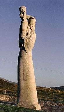 | |||
| Lochboisdale, School And School House With Garden And Boundary Walls And Gatepiers | 57°09′17″N 7°18′37″W / 57.154738°N 7.310344°W | Category C(S) | 44722 | | |||
| Benbecula, Nunton Steadings | 57°27′28″N 7°23′47″W / 57.457776°N 7.396389°W | Category B | 43387 | | |||
| Pollacher Inn | 57°06′19″N 7°22′32″W / 57.105197°N 7.375438°W | Category B | 18739 | | |||
| 472 South Lochboisdale And Byre And Shed (Campbell) | 57°08′07″N 7°18′57″W / 57.1354°N 7.315826°W | Category A | 18746 | | |||
| West Kilbride Byre (At O.S. Grid Reference Nf 755 145) (Alasdair Walker) | 57°06′24″N 7°21′42″W / 57.106541°N 7.361758°W | Category B | 18751 | | |||
| Daliburgh (Thatched Cottage At O.S. Grid Reference Nf 741210) | 57°09′52″N 7°23′32″W / 57.164523°N 7.392334°W | Category B | 18765 | | |||
| Rhughasinish Flora Macleod | 57°22′57″N 7°16′55″W / 57.382409°N 7.282024°W | Category B | 19907 | | |||
| Eochar 51 Balgarva | 57°23′47″N 7°22′54″W / 57.396297°N 7.381789°W | Category B | 18769 | | |||
| Eriskay St Michael's R.C. Church | 57°05′13″N 7°18′24″W / 57.086885°N 7.306748°W | Category C(S) | 18770 | 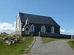 | |||
| 429 North Lochboisdale | 57°09′44″N 7°19′28″W / 57.162181°N 7.324499°W | Category A | 18776 | | |||
| Garrynamonie, Our Lady Of Sorrows Rc Church Including Boundary Walls And Gatepiers | 57°07′28″N 7°21′33″W / 57.124508°N 7.359133°W | Category B | 51401 | | |||
| Eochar Bualadubh Mrs Johnstone (Cottage To North Of Former Museum) | 57°23′32″N 7°20′53″W / 57.392093°N 7.34812°W | Category A | 19908 | | |||
| Benbecula 5, 6 Hacklet | 57°24′43″N 7°18′16″W / 57.41191°N 7.304358°W | Category B | 18754 | | |||
| 99 Carnan | 57°24′04″N 7°20′45″W / 57.401185°N 7.345731°W | Category B | 18762 | | |||
| Eochar 96 Bualadubh | 57°23′31″N 7°21′23″W / 57.392041°N 7.356313°W | Category B | 18768 | | |||
| North Boisdale Burial Ground | 57°07′52″N 7°23′45″W / 57.131089°N 7.395915°W | Category B | 18774 | | |||
| Askernish House, Garden Walls And Gatepiers | 57°11′22″N 7°24′23″W / 57.189346°N 7.406255°W | Category B | 18780 | | |||
| Ormaclett House Beside Former Clanranald Mansion | 57°15′37″N 7°24′33″W / 57.260274°N 7.409114°W | Category C(S) | 18738 | | |||
| 7 West Gerinish | 57°21′09″N 7°21′48″W / 57.352509°N 7.363224°W | Category B | 18749 | | |||
| Benbecula Griminish Church Of Scotland & Manse | 57°26′40″N 7°20′08″W / 57.444384°N 7.335692°W | Category C(S) | 18753 | | |||
| Benbecula Nunton Former Chapel & Cemetery Enclosure | 57°27′32″N 7°23′40″W / 57.458818°N 7.394339°W | Category B | 18759 | 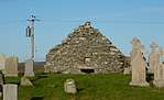 | |||
| 323 North Boisdale | 57°08′16″N 7°23′14″W / 57.137857°N 7.387352°W | Category B | 18775 | | |||
| Ormaclett Castle And Forecourt Wall (Clanranald Mansion) | 57°15′37″N 7°24′33″W / 57.260274°N 7.409114°W | Category B | 18778 | 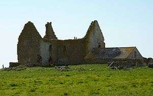 | |||
| Isle Of South Uist, Iochdar Church Including Boundary Walls And Gatepiers | 57°23′33″N 7°20′58″W / 57.392472°N 7.349576°W | Category C(S) | 48278 | | |||
| 11 Rhughasinish | 57°23′08″N 7°17′55″W / 57.385647°N 7.298721°W | Category B | 18740 | | |||
| 374 South Boisdale | 57°07′38″N 7°22′52″W / 57.127302°N 7.381049°W | Category C(S) | 18742 | | |||
| 466 South Lochboisdale | 57°08′09″N 7°18′43″W / 57.135807°N 7.311978°W | Category B | 18744 | | |||
| 472 South Lochboisdale | 57°08′05″N 7°18′53″W / 57.134654°N 7.314742°W | Category B | 18745 | | |||
| Staoligarry Thatched Cottage (N.C.C. Office) (Property Of No 135) | 57°19′23″N 7°22′09″W / 57.323058°N 7.369036°W | Category B | 18748 | |
Key
The scheme for classifying buildings in Scotland is:
- Category A: "buildings of national or international importance, either architectural or historic; or fine, little-altered examples of some particular period, style or building type."[1]
- Category B: "buildings of regional or more than local importance; or major examples of some particular period, style or building type, which may have been altered."[1]
- Category C: "buildings of local importance; lesser examples of any period, style, or building type, as originally constructed or moderately altered; and simple traditional buildings which group well with other listed buildings."[1]
In March 2016 there were 47,288 listed buildings in Scotland. Of these, 8 per cent were Category A, and 50 per cent were Category B, with the rest listed at Category C.[2]
See also
Notes
- ↑ Sometimes known as OSGB36, the grid reference (where provided) is based on the British national grid reference system used by the Ordnance Survey.
• "Guide to National Grid". Ordnance Survey. Retrieved 2007-12-12.
• "Get-a-map". Ordnance Survey. Retrieved 2007-12-17. - ↑ The "HB Number" is a unique number assigned to each listed building by Historic Environment Scotland.
References
- All entries, addresses and coordinates are based on data from Historic Scotland. This data falls under the Open Government Licence
- 1 2 3 "What is Listing?". Historic Environment Scotland. Retrieved 29 May 2018.
- ↑ Scotland's Historic Environment Audit 2016 (PDF). Historic Environment Scotland and the Built Environment Forum Scotland. pp. 15–16. Retrieved 29 May 2018.
This article is issued from
Wikipedia.
The text is licensed under Creative Commons - Attribution - Sharealike.
Additional terms may apply for the media files.