| Name |
Location |
Date Listed |
Grid Ref. [note 1] |
Geo-coordinates |
Notes |
HB Number [note 2] |
Image |
| Limekilns, Port Ramsay, Lismore |
|
|
|
56°33′17″N 5°26′39″W / 56.554691°N 5.44407°W / 56.554691; -5.44407 (Limekilns, Port Ramsay, Lismore) |
Category B |
13341 |

|
| Limekilns, Stores And Pier, Port Kilcheran, Lismore |
|
|
|
56°29′22″N 5°32′00″W / 56.489327°N 5.533434°W / 56.489327; -5.533434 (Limekilns, Stores And Pier, Port Kilcheran, Lismore) |
Category B |
13342 |
|
| Gate Lodge, Aird's Estate |
|
|
|
56°33′34″N 5°23′23″W / 56.559332°N 5.389773°W / 56.559332; -5.389773 (Gate Lodge, Aird's Estate) |
Category C(S) |
12364 |
|
| Bank House (Post Office) Tynribbie |
|
|
|
56°33′44″N 5°21′29″W / 56.562097°N 5.358125°W / 56.562097; -5.358125 (Bank House (Post Office) Tynribbie) |
Category B |
12336 |
|
| Portnacroish Cottages Portnacroish |
|
|
|
56°34′20″N 5°22′44″W / 56.572132°N 5.378949°W / 56.572132; -5.378949 (Portnacroish Cottages Portnacroish) |
Category B |
12341 |
|
| Portnacroish Inn Portnacroish |
|
|
|
56°34′20″N 5°22′46″W / 56.572333°N 5.379488°W / 56.572333; -5.379488 (Portnacroish Inn Portnacroish) |
Category B |
12342 |
|
| Shuna Farmhouse |
|
|
|
56°35′01″N 5°23′55″W / 56.583482°N 5.398551°W / 56.583482; -5.398551 (Shuna Farmhouse) |
Category B |
12343 |
|
| Portnacroish, St Cross Churchyard, Stalcaine Memorial |
|
|
|
56°34′17″N 5°22′33″W / 56.571441°N 5.375923°W / 56.571441; -5.375923 (Portnacroish, St Cross Churchyard, Stalcaine Memorial) |
Category C(S) |
12348 |
|
| Bachull House |
|
|
|
56°32′14″N 5°28′36″W / 56.53731°N 5.476758°W / 56.53731; -5.476758 (Bachull House) |
Category B |
12351 |
|
| Airds House |
|
|
|
56°33′01″N 5°24′10″W / 56.550158°N 5.402722°W / 56.550158; -5.402722 (Airds House) |
Category A |
12363 |
|
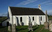
| Lismore Kirk (Formerly Cathedral Church Of St Moluag) Clachan |
|
|
|
56°32′05″N 5°28′50″W / 56.534652°N 5.4805°W / 56.534652; -5.4805 (Lismore Kirk (Formerly Cathedral Church Of St Moluag) Clachan) |
Category B |
12349 |
 Upload another image
|
| Clachan, Kilmoluag House, Formerly Lismore Manse |
|
|
|
56°32′02″N 5°28′53″W / 56.533945°N 5.48133°W / 56.533945; -5.48133 (Clachan, Kilmoluag House, Formerly Lismore Manse) |
Category C(S) |
12350 |
|
| Hawthorn House (Near Bachull House) |
|
|
|
56°32′14″N 5°28′30″W / 56.537123°N 5.475097°W / 56.537123; -5.475097 (Hawthorn House (Near Bachull House)) |
Category C(S) |
12352 |
|
| Cottages, 3-11 Port Ramsay |
|
|
|
56°33′11″N 5°26′50″W / 56.552939°N 5.44728°W / 56.552939; -5.44728 (Cottages, 3-11 Port Ramsay) |
Category C(S) |
12356 |
|
| Cottages, 12-13 Port Ramsay |
|
|
|
56°33′08″N 5°26′54″W / 56.552284°N 5.448213°W / 56.552284; -5.448213 (Cottages, 12-13 Port Ramsay) |
Category C(S) |
12357 |
|
| Kinlochlaich House |
|
|
|
56°33′58″N 5°21′23″W / 56.566011°N 5.356372°W / 56.566011; -5.356372 (Kinlochlaich House) |
Category B |
12367 |
|
| Invernahyle House |
|
|
|
56°33′04″N 5°19′15″W / 56.551053°N 5.320882°W / 56.551053; -5.320882 (Invernahyle House) |
Category B |
12338 |
|
| Castle Shuna |
|
|
|
56°34′47″N 5°23′45″W / 56.579844°N 5.395813°W / 56.579844; -5.395813 (Castle Shuna) |
Category B |
12344 |
|
| Port Appin, Old Ferry House |
|
|
|
56°33′11″N 5°24′52″W / 56.553029°N 5.414423°W / 56.553029; -5.414423 (Port Appin, Old Ferry House) |
Category B |
12421 |
|
| Achnacroish Cottage |
|
|
|
56°30′51″N 5°29′37″W / 56.514143°N 5.493676°W / 56.514143; -5.493676 (Achnacroish Cottage) |
Category C(S) |
12346 |
|
| Castle Coeffin |
|
|
|
56°32′12″N 5°29′32″W / 56.536792°N 5.492314°W / 56.536792; -5.492314 (Castle Coeffin) |
Category B |
12353 |
|
| Old Appin Kirk Tynribbie |
|
|
|
56°33′52″N 5°21′20″W / 56.564468°N 5.355584°W / 56.564468; -5.355584 (Old Appin Kirk Tynribbie) |
Category C(S) |
12366 |
|
| Achnacone House |
|
|
|
56°33′41″N 5°20′34″W / 56.561282°N 5.342684°W / 56.561282; -5.342684 (Achnacone House) |
Category B |
12337 |
|
| Cottages, 1-2 Port Ramsay |
|
|
|
56°33′11″N 5°26′49″W / 56.553155°N 5.446958°W / 56.553155; -5.446958 (Cottages, 1-2 Port Ramsay) |
Category C(S) |
12355 |
|
| Kilcheran Home Farm |
|
|
|
56°29′27″N 5°32′08″W / 56.490744°N 5.535435°W / 56.490744; -5.535435 (Kilcheran Home Farm) |
Category B |
12359 |
|
| Lismore Lighthouse Eilean Musdile |
|
|
|
56°27′20″N 5°36′27″W / 56.455574°N 5.607487°W / 56.455574; -5.607487 (Lismore Lighthouse Eilean Musdile) |
Category A |
12360 |
|
| Benderloch Ferry House, North Shian |
|
|
|
56°32′03″N 5°23′34″W / 56.534179°N 5.392697°W / 56.534179; -5.392697 (Benderloch Ferry House, North Shian) |
Category C(S) |
12339 |
|
| Holy Cross Episcopal Church, Portnacroish |
|
|
|
56°34′18″N 5°22′35″W / 56.571647°N 5.376284°W / 56.571647; -5.376284 (Holy Cross Episcopal Church, Portnacroish) |
Category B |
12340 |
|
| Castle Stalker |
|
|
|
56°34′18″N 5°23′10″W / 56.571539°N 5.386192°W / 56.571539; -5.386192 (Castle Stalker) |
Category A |
12345 |
|
| Achinduin Castle Acha-Dun |
|
|
|
56°29′39″N 5°34′07″W / 56.494147°N 5.568568°W / 56.494147; -5.568568 (Achinduin Castle Acha-Dun) |
Category B |
12358 |
|
| Sealladhnan Ellean Port Appin |
|
|
|
56°33′20″N 5°24′34″W / 56.555439°N 5.40948°W / 56.555439; -5.40948 (Sealladhnan Ellean Port Appin) |
Category C(S) |
12361 |
|
| Appin Parish Manse (Old F.C. Manse.) Ardtur |
|
|
|
56°33′45″N 5°23′04″W / 56.562626°N 5.384353°W / 56.562626; -5.384353 (Appin Parish Manse (Old F.C. Manse.) Ardtur) |
Category C(S) |
12365 |
|
| Old Corn Mill At Balngowan |
|
|
|
56°31′11″N 5°29′10″W / 56.519659°N 5.486166°W / 56.519659; -5.486166 (Old Corn Mill At Balngowan) |
Category B |
12347 |
|
| The Old Smiddy, Port Appin |
|
|
|
56°33′16″N 5°24′24″W / 56.554398°N 5.406782°W / 56.554398; -5.406782 (The Old Smiddy, Port Appin) |
Category C(S) |
12362 |
|