List of listed buildings in Laggan, Badenoch
This is a list of listed buildings in the parish of Laggan in Badenoch, in the Highland council area of Scotland.
List
| Name | Location | Date Listed | Grid Ref. [note 1] | Geo-coordinates | Notes | HB Number [note 2] | Image |
|---|---|---|---|---|---|---|---|
| Garvamore "Barracks" | 57°00′59″N 4°25′34″W / 57.016326°N 4.425978°W | Category A | 6899 | 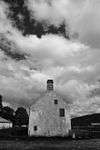 | |||
| Lime Kiln | Kinloch Laggan | 56°58′32″N 4°24′28″W / 56.975421°N 4.407765°W | Category C(S) | 6908 |  | ||
| Catlodge, Catlodge Lodge And Gate Piers | 57°00′24″N 4°15′07″W / 57.006755°N 4.251963°W | Category B | 6912 | | |||
| Catlodge Cottages | 57°00′23″N 4°15′02″W / 57.006377°N 4.250523°W | Category C(S) | 6913 | | |||
| Dalchully House | 57°00′44″N 4°18′56″W / 57.0121°N 4.31557°W | Category C(S) | 6896 | | |||
| Dalwhinnie Distillery and Bonded Warehouse | Dalwhinnie | 56°56′24″N 4°14′21″W / 56.939985°N 4.239156°W | Category B | 6898 | 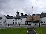 | ||
| Falls Of Truim, Old Schoolhouse Including Garden Walls | 57°00′15″N 4°10′29″W / 57.004302°N 4.174794°W | Category C(S) | 49646 | | |||
| Melgarve, Corrieyairack Pass, Bridge Over Allt Feith A Mhoraire | 57°01′50″N 4°31′29″W / 57.03046°N 4.524663°W | Category B | 12373 | | |||
| Glentruim House Stables (By Newtonmore) | 57°01′39″N 4°10′36″W / 57.027517°N 4.176579°W | Category C(S) | 6906 | | |||
| Ardverikie House, Outbuildings, Game Larders, Boat House And Walled Garden | 56°57′19″N 4°27′15″W / 56.955321°N 4.45428°W | Category A | 6910 | 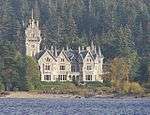 | |||
| Crubenmore Bridge | 56°59′43″N 4°10′50″W / 56.995226°N 4.180455°W | Category C(S) | 50910 | | |||
| Garvamore, Garva Bridge Over River Spey (St George's Bridge) | 57°01′12″N 4°26′12″W / 57.020118°N 4.436605°W | Category A | 6900 | 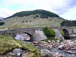 | |||
| Glentruim House (By Newtonmore) | 57°01′36″N 4°10′28″W / 57.026648°N 4.174353°W | Category B | 6903 | | |||
| Glentruim House, Gate Lodge, Gates And Gatepiers (By Newtonmore) | 57°01′26″N 4°09′54″W / 57.024009°N 4.164873°W | Category C(S) | 6905 | | |||
| Laggan Bridge, Laggan Parish Church And Burial Ground, Church Of Scotland | Laggan | 57°01′09″N 4°16′57″W / 57.01924°N 4.282537°W | Category B | 6909 |  | ||
| Ardverikie Gate Lodge, Gate Piers And Bridge Over River Pattack | Kinloch Laggan | 56°58′30″N 4°24′18″W / 56.97509°N 4.404897°W | Category A | 6911 | .jpg) | ||
| Cluny Castle | 57°01′11″N 4°13′57″W / 57.019794°N 4.232388°W | Category A | 6914 | | |||
| Cluny Castle, Stable/Dwelling Range | 57°01′17″N 4°14′02″W / 57.021294°N 4.233978°W | Category B | 6915 | | |||
| Cluny Castle, East Lodge, Gates And Gate Piers | 57°01′14″N 4°13′45″W / 57.020686°N 4.229246°W | Category B | 6916 | | |||
| Corrieyairack Pass, Melgarve, Drummin Bridge Over Caoehan Riabhaeh Burn | 57°01′49″N 4°32′00″W / 57.030366°N 4.533292°W | Category B | 6895 | | |||
| Kinloch Laggan Old St Kenneth's Church And Burial Ground | Kinloch Laggan | 56°58′31″N 4°24′42″W / 56.975157°N 4.411648°W | Category C(S) | 6907 | 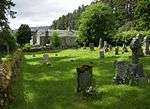 | ||
| Glentruim House Macpherson Of Glentruim Burial Ground (By Newtonmore) | 57°01′46″N 4°10′37″W / 57.029452°N 4.176906°W | Category C(S) | 6904 | | |||
| Cluny Castle, West Lodge And Gate Piers With Flanking Quadrants And End Pavilion | 57°01′05″N 4°14′23″W / 57.018081°N 4.239798°W | Category B | 6917 | | |||
| Craig Dhu Lodge | 57°01′49″N 4°11′14″W / 57.030236°N 4.187103°W | Category B | 49688 | | |||
| Glenshero Lodge | 57°00′24″N 4°23′23″W / 57.006763°N 4.389615°W | Category C(S) | 6901 | | |||
| Cluny Castle, Burial Ground | 57°01′04″N 4°14′14″W / 57.017757°N 4.237291°W | Category C(S) | 6894 | | |||
| Glen Shirra, Old Wade Bridge (Over Dry Burn) | 57°00′25″N 4°22′54″W / 57.006925°N 4.381605°W | Category B | 6902 | | |||
| Dalchully Bridge Over River Mashie | 57°00′43″N 4°18′24″W / 57.011957°N 4.306782°W | Category B | 6897 | |
Key
The scheme for classifying buildings in Scotland is:
- Category A: "buildings of national or international importance, either architectural or historic; or fine, little-altered examples of some particular period, style or building type."[1]
- Category B: "buildings of regional or more than local importance; or major examples of some particular period, style or building type, which may have been altered."[1]
- Category C: "buildings of local importance; lesser examples of any period, style, or building type, as originally constructed or moderately altered; and simple traditional buildings which group well with other listed buildings."[1]
In March 2016 there were 47,288 listed buildings in Scotland. Of these, 8 per cent were Category A, and 50 per cent were Category B, with the rest listed at Category C.[2]
See also
Notes
- ↑ Sometimes known as OSGB36, the grid reference (where provided) is based on the British national grid reference system used by the Ordnance Survey.
• "Guide to National Grid". Ordnance Survey. Retrieved 2007-12-12.
• "Get-a-map". Ordnance Survey. Retrieved 2007-12-17. - ↑ The "HB Number" is a unique number assigned to each listed building by Historic Environment Scotland.
References
- All entries, addresses and coordinates are based on data from Historic Scotland. This data falls under the Open Government Licence
- 1 2 3 "What is Listing?". Historic Environment Scotland. Retrieved 29 May 2018.
- ↑ Scotland's Historic Environment Audit 2016 (PDF). Historic Environment Scotland and the Built Environment Forum Scotland. pp. 15–16. Retrieved 29 May 2018.
This article is issued from
Wikipedia.
The text is licensed under Creative Commons - Attribution - Sharealike.
Additional terms may apply for the media files.