| Name |
Location |
Date Listed |
Grid Ref. [note 1] |
Geo-coordinates |
Notes |
HB Number [note 2] |
Image |
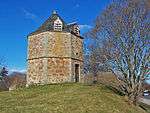
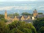
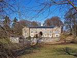
| Culloden House Dovecote |
|
|
|
57°29′16″N 4°08′10″W / 57.487766°N 4.136078°W / 57.487766; -4.136078 (Culloden House Dovecote) |
Category B |
10953 |
 Upload another image
|
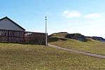
| Caledonian Canal, Dochgarroch Locks, Lock Keeper's Cottage And Barn |
|
|
|
57°25′59″N 4°18′12″W / 57.433066°N 4.303239°W / 57.433066; -4.303239 (Caledonian Canal, Dochgarroch Locks, Lock Keeper's Cottage And Barn) |
Category C(S) |
8033 |

|
| Culloden, Loch Lann (Former Culloden House Kennels) |
|
|
|
57°29′11″N 4°08′00″W / 57.48626°N 4.133221°W / 57.48626; -4.133221 (Culloden, Loch Lann (Former Culloden House Kennels)) |
Category B |
8040 |
|
| Culloden Ice House |
|
|
|
57°29′26″N 4°07′46″W / 57.490682°N 4.129424°W / 57.490682; -4.129424 (Culloden Ice House) |
Category C(S) |
8041 |
 Upload another image
|
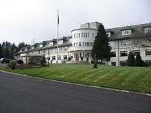
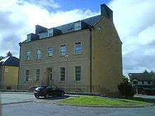
| Drumossie Hotel |
|
|
|
57°27′27″N 4°09′35″W / 57.457504°N 4.159819°W / 57.457504; -4.159819 (Drumossie Hotel) |
Category B |
8046 |
 Upload another image
|
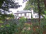
| Dunain House |
|
|
|
57°27′03″N 4°17′20″W / 57.450798°N 4.288753°W / 57.450798; -4.288753 (Dunain House) |
Category B |
8047 |
|
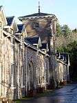
| Leys Castle, The Grange |
|
|
|
57°26′07″N 4°12′05″W / 57.43514°N 4.201319°W / 57.43514; -4.201319 (Leys Castle, The Grange) |
Category B |
8055 |
|
| Ness Castle And Glass Houses |
|
|
|
57°26′38″N 4°14′56″W / 57.444002°N 4.249014°W / 57.444002; -4.249014 (Ness Castle And Glass Houses) |
Category B |
8056 |
|
| Culloden House Walled Garden |
|
|
|
57°29′31″N 4°08′16″W / 57.492061°N 4.137664°W / 57.492061; -4.137664 (Culloden House Walled Garden) |
Category B |
10952 |
|
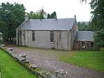
| Bona Church Of Scotland And Manse |
|
|
|
57°24′28″N 4°20′24″W / 57.407703°N 4.340073°W / 57.407703; -4.340073 (Bona Church Of Scotland And Manse) |
Category B |
8032 |
|
| Cradlehall House |
|
|
|
57°28′27″N 4°09′52″W / 57.474261°N 4.164511°W / 57.474261; -4.164511 (Cradlehall House) |
Category B |
8036 |
|
| Drumdevan House |
|
|
|
57°26′31″N 4°14′31″W / 57.441808°N 4.242047°W / 57.441808; -4.242047 (Drumdevan House) |
Category C(S) |
8045 |
|
| Dochfour House, Gardener's Cottage And Walled Garden |
|
|
|
57°25′08″N 4°19′43″W / 57.41879°N 4.328523°W / 57.41879; -4.328523 (Dochfour House, Gardener's Cottage And Walled Garden) |
Category C(S) |
8065 |
|
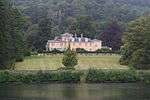
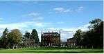
| Dochfour House |
|
|
|
57°25′18″N 4°19′31″W / 57.421699°N 4.325276°W / 57.421699; -4.325276 (Dochfour House) |
Category A |
8028 |
 Upload another image
|
| Craig Dunain Hospital |
|
|
|
57°27′50″N 4°16′30″W / 57.46378°N 4.274958°W / 57.46378; -4.274958 (Craig Dunain Hospital) |
Category B |
8037 |
 Upload another image
|
| Culloden House, Gate Piers And Gardeners' Bothy |
|
|
|
57°29′26″N 4°08′07″W / 57.490431°N 4.13525°W / 57.490431; -4.13525 (Culloden House, Gate Piers And Gardeners' Bothy) |
Category A |
8039 |
 Upload another image
|
| Stratton Lodge Hotel |
|
|
|
57°29′22″N 4°09′07″W / 57.489537°N 4.1519°W / 57.489537; -4.1519 (Stratton Lodge Hotel) |
Category B |
8060 |
.jpg) Upload another image
|
| Abriachan, Balbeg Mill |
|
|
|
57°22′57″N 4°23′30″W / 57.382407°N 4.391751°W / 57.382407; -4.391751 (Abriachan, Balbeg Mill) |
Category C(S) |
8029 |
|
| Bona Free Church and Burial Ground, Dochfour |
|
|
|
57°24′57″N 4°19′43″W / 57.415888°N 4.328505°W / 57.415888; -4.328505 (Bona Free Church and Burial Ground, Dochfour) |
Category C(S) |
8043 |
 Upload another image
|
| Dochfour House Obelisk And Private Burial Ground |
|
|
|
57°25′43″N 4°18′56″W / 57.428628°N 4.315438°W / 57.428628; -4.315438 (Dochfour House Obelisk And Private Burial Ground) |
Category B |
8063 |
|
| Dochfour, Church Cottage, Kirkton |
|
|
|
57°24′59″N 4°19′42″W / 57.416359°N 4.328285°W / 57.416359; -4.328285 (Dochfour, Church Cottage, Kirkton) |
Category C(S) |
8066 |
|
| Allanfearn Farmhouse |
|
|
|
57°29′58″N 4°08′39″W / 57.499399°N 4.144169°W / 57.499399; -4.144169 (Allanfearn Farmhouse) |
Category B |
8030 |
|
| Dunain Park Hotel |
|
|
|
57°27′13″N 4°16′29″W / 57.453606°N 4.274592°W / 57.453606; -4.274592 (Dunain Park Hotel) |
Category C(S) |
8048 |
|
| Inshes House |
|
|
|
57°27′54″N 4°10′38″W / 57.464886°N 4.177263°W / 57.464886; -4.177263 (Inshes House) |
Category B |
8049 |
|
| Killianan Burial Ground |
|
|
|
57°22′48″N 4°22′39″W / 57.379893°N 4.377446°W / 57.379893; -4.377446 (Killianan Burial Ground) |
Category C(S) |
8052 |
|
| Raigmore Tower |
|
|
|
57°28′14″N 4°08′46″W / 57.470526°N 4.145995°W / 57.470526; -4.145995 (Raigmore Tower) |
Category B |
8057 |
|
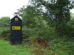
| AA Sentry Box (No 631), Brachla |
|
|
|
57°21′49″N 4°23′36″W / 57.363585°N 4.393469°W / 57.363585; -4.393469 (AA Sentry Box (No 631), Brachla) |
Category B |
49223 |
 Upload another image
|
| Culloden House Stables and Yard Wall |
|
|
|
57°29′18″N 4°08′09″W / 57.488472°N 4.135786°W / 57.488472; -4.135786 (Culloden House Stables and Yard Wall) |
Category A |
10954 |
 Upload another image
|
| Caledonian Canal, Lochend, Bona Lighthouse |
|
|
|
57°24′29″N 4°19′43″W / 57.408156°N 4.328713°W / 57.408156; -4.328713 (Caledonian Canal, Lochend, Bona Lighthouse) |
Category B |
8034 |
|
| Culloden Moor, Kings Stable Cottage |
|
|
|
57°28′34″N 4°06′50″W / 57.47608°N 4.113996°W / 57.47608; -4.113996 (Culloden Moor, Kings Stable Cottage) |
Category B |
8042 |
|
| Leys Castle Lodge |
|
|
|
57°26′19″N 4°12′15″W / 57.438659°N 4.204047°W / 57.438659; -4.204047 (Leys Castle Lodge) |
Category C(S) |
8054 |
|
| Seafield Of Raigmore |
|
|
|
57°29′08″N 4°10′31″W / 57.485668°N 4.175246°W / 57.485668; -4.175246 (Seafield Of Raigmore) |
Category B |
8058 |
|
| Dochgarroch House |
|
|
|
57°26′14″N 4°18′20″W / 57.437326°N 4.30564°W / 57.437326; -4.30564 (Dochgarroch House) |
Category B |
8067 |
|
| Bogbain Farmhouse |
|
|
|
57°26′54″N 4°09′14″W / 57.44829°N 4.153759°W / 57.44829; -4.153759 (Bogbain Farmhouse) |
Category C(S) |
8031 |
|
| Inshes House, Tower House In Grounds |
|
|
|
57°27′53″N 4°10′38″W / 57.464672°N 4.177166°W / 57.464672; -4.177166 (Inshes House, Tower House In Grounds) |
Category A |
8050 |
|
| Inshes, Helen's Lodge |
|
|
|
57°27′48″N 4°10′49″W / 57.463404°N 4.180359°W / 57.463404; -4.180359 (Inshes, Helen's Lodge) |
Category C(S) |
8051 |
|
| Leys Castle And Garden Terraces |
|
|
|
57°26′24″N 4°12′02″W / 57.43995°N 4.200609°W / 57.43995; -4.200609 (Leys Castle And Garden Terraces) |
Category A |
8053 |
|
| Dochfour House, East Drive Entrance Gate Piers And Gates, Gate Lodge And Policy Walls Fronting A82 Road |
|
|
|
57°25′41″N 4°18′36″W / 57.428029°N 4.309919°W / 57.428029; -4.309919 (Dochfour House, East Drive Entrance Gate Piers And Gates, Gate Lodge And Policy Walls Fronting A82 Road) |
Category B |
8061 |
|
| Dochfour House, Farm Steading |
|
|
|
57°25′26″N 4°19′27″W / 57.423838°N 4.32428°W / 57.423838; -4.32428 (Dochfour House, Farm Steading) |
Category B |
8062 |
 Upload another image
|
| Castlehill House |
|
|
|
57°28′11″N 4°10′29″W / 57.469631°N 4.17461°W / 57.469631; -4.17461 (Castlehill House) |
Category B |
8035 |
 Upload another image
|
| Culduthel House (Part Of Culduthel Hospital) |
|
|
|
57°27′03″N 4°13′39″W / 57.450809°N 4.227464°W / 57.450809; -4.227464 (Culduthel House (Part Of Culduthel Hospital)) |
Category B |
8038 |
 Upload another image
|
| Dochgarroch, Dunain Lodge (West Gate Lodge To Docharroch House) And Gate Piers |
|
|
|
57°26′38″N 4°17′48″W / 57.443994°N 4.29676°W / 57.443994; -4.29676 (Dochgarroch, Dunain Lodge (West Gate Lodge To Docharroch House) And Gate Piers) |
Category B |
8044 |
|
| Stoneyfield House |
|
|
|
57°28′55″N 4°11′09″W / 57.481961°N 4.185903°W / 57.481961; -4.185903 (Stoneyfield House) |
Category B |
8059 |
 Upload another image
|
| Dochfour House, Dairy |
|
|
|
57°25′27″N 4°19′22″W / 57.424196°N 4.32287°W / 57.424196; -4.32287 (Dochfour House, Dairy) |
Category B |
8064 |
|