| Name |
Location |
Date Listed |
Grid Ref. [note 1] |
Geo-coordinates |
Notes |
HB Number [note 2] |
Image |
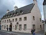
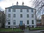
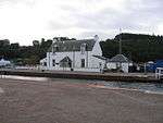
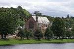
| Ness Walk, Ballifeary House (Home Of Rest) |
|
|
|
57°28′07″N 4°13′49″W / 57.468515°N 4.230275°W / 57.468515; -4.230275 (Ness Walk, Ballifeary House (Home Of Rest)) |
Category B |
35335 |

|
| Old Edinburgh Court and Archway At Entrance, Old Edinburgh Road |
|
|
|
57°28′07″N 4°12′56″W / 57.468588°N 4.215421°W / 57.468588; -4.215421 (Old Edinburgh Court and Archway At Entrance, Old Edinburgh Road) |
Category B |
35338 |
.jpg) Upload another image
|
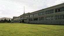
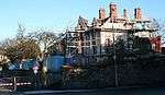
| Cameron Barracks, Perth Road |
|
|
|
57°28′55″N 4°12′16″W / 57.481844°N 4.204513°W / 57.481844; -4.204513 (Cameron Barracks, Perth Road) |
Category B |
35340 |
.jpg) Upload another image
|
| Perth Road, Viewfield House |
|
|
|
57°28′30″N 4°12′03″W / 57.474936°N 4.200778°W / 57.474936; -4.200778 (Perth Road, Viewfield House) |
Category C(S) |
35342 |
|
| 15-45 (Odd Numbers Only) Queensgate |
|
|
|
57°28′45″N 4°13′35″W / 57.47906°N 4.226431°W / 57.47906; -4.226431 (15-45 (Odd Numbers Only) Queensgate) |
Category B |
35344 |
|
| 18-30 (Even Numbers Only) Queensgate, 58 And 60 Church Street And 2 Post Office Lane |
|
|
|
57°28′45″N 4°13′37″W / 57.479304°N 4.226813°W / 57.479304; -4.226813 (18-30 (Even Numbers Only) Queensgate, 58 And 60 Church Street And 2 Post Office Lane) |
Category B |
35345 |
|
| 19 And 21 Southside Road |
|
|
|
57°28′26″N 4°13′02″W / 57.473958°N 4.217131°W / 57.473958; -4.217131 (19 And 21 Southside Road) |
Category C(S) |
35347 |
|
| 26 Southside Road |
|
|
|
57°28′26″N 4°13′04″W / 57.473954°N 4.217881°W / 57.473954; -4.217881 (26 Southside Road) |
Category B |
35350 |
|
| 46 Southside Road |
|
|
|
57°28′19″N 4°13′16″W / 57.472066°N 4.221019°W / 57.472066; -4.221019 (46 Southside Road) |
Category C(S) |
35353 |
|
| Stratherrick Road, Drummond Tower |
|
|
|
57°27′33″N 4°14′06″W / 57.459167°N 4.234974°W / 57.459167; -4.234974 (Stratherrick Road, Drummond Tower) |
Category B |
35358 |
|
| 1-17 (Odd Numbers Only) Union Street |
|
|
|
57°28′44″N 4°13′28″W / 57.478825°N 4.224432°W / 57.478825; -4.224432 (1-17 (Odd Numbers Only) Union Street) |
Category B |
35366 |
|
| 3 And 4 Viewplace And 2 And 4 Culduthel Road |
|
|
|
57°28′30″N 4°13′31″W / 57.474903°N 4.225211°W / 57.474903; -4.225211 (3 And 4 Viewplace And 2 And 4 Culduthel Road) |
Category C(S) |
35373 |
|
| 2 Dores Road, The Firs, And Garden Wall |
|
|
|
57°27′32″N 4°14′19″W / 57.458844°N 4.238489°W / 57.458844; -4.238489 (2 Dores Road, The Firs, And Garden Wall) |
Category B |
35216 |
|
| 21 Douglas Row |
|
|
|
57°28′48″N 4°13′49″W / 57.480089°N 4.23018°W / 57.480089; -4.23018 (21 Douglas Row) |
Category B |
35234 |
|
| 2 And 4 Grant Street And 1 Anderson Street |
|
|
|
57°29′04″N 4°13′59″W / 57.484314°N 4.233174°W / 57.484314; -4.233174 (2 And 4 Grant Street And 1 Anderson Street) |
Category B |
35247 |
|
| 63 Haugh Road |
|
|
|
57°28′21″N 4°13′35″W / 57.472476°N 4.226264°W / 57.472476; -4.226264 (63 Haugh Road) |
Category C(S) |
35249 |
|
| 1, 3, 5 And 7 High Street |
|
|
|
57°28′40″N 4°13′31″W / 57.477687°N 4.22528°W / 57.477687; -4.22528 (1, 3, 5 And 7 High Street) |
Category B |
35250 |
|
| 17 And 19 High Street |
|
|
|
57°28′40″N 4°13′29″W / 57.477868°N 4.224707°W / 57.477868; -4.224707 (17 And 19 High Street) |
Category B |
35252 |
|
| 21 And 23 High Street And 1-21 (Odd Numbers Only) Lombard Street, And Baron Taylor's Street |
|
|
|
57°28′41″N 4°13′28″W / 57.478024°N 4.224517°W / 57.478024; -4.224517 (21 And 23 High Street And 1-21 (Odd Numbers Only) Lombard Street, And Baron Taylor's Street) |
Category B |
35253 |
|
| Town House, High Street |
|
|
|
57°28′38″N 4°13′30″W / 57.477261°N 4.225004°W / 57.477261; -4.225004 (Town House, High Street) |
Category A |
35260 |
.jpg) Upload another image
See more images
|
| 2 Hill Place |
|
|
|
57°28′40″N 4°13′21″W / 57.477701°N 4.222462°W / 57.477701; -4.222462 (2 Hill Place) |
Category B |
35262 |
|
| 5 Huntly Place |
|
|
|
57°28′55″N 4°14′07″W / 57.481886°N 4.235311°W / 57.481886; -4.235311 (5 Huntly Place) |
Category B |
35266 |
|
| 41-44 Huntly Street (All Numbers) |
|
|
|
57°28′45″N 4°13′53″W / 57.479095°N 4.231521°W / 57.479095; -4.231521 (41-44 Huntly Street (All Numbers)) |
Category B |
35278 |
|
| 20 Island Bank Road, Maybank |
|
|
|
57°27′48″N 4°13′46″W / 57.463461°N 4.229484°W / 57.463461; -4.229484 (20 Island Bank Road, Maybank) |
Category C(S) |
35296 |
|
| 78 King Street |
|
|
|
57°28′45″N 4°14′00″W / 57.479118°N 4.233307°W / 57.479118; -4.233307 (78 King Street) |
Category C(S) |
35301 |
|
| Crown Primary School, Kingmills Road |
|
|
|
57°28′37″N 4°13′03″W / 57.476892°N 4.217375°W / 57.476892; -4.217375 (Crown Primary School, Kingmills Road) |
Category B |
35302 |
.jpg) Upload another image
|
| 3 Moray Park, Island Bank Road |
|
|
|
57°28′16″N 4°13′37″W / 57.470973°N 4.226923°W / 57.470973; -4.226923 (3 Moray Park, Island Bank Road) |
Category B |
35316 |
|
| 1, 1A, 1B And 3 Muirtown Street |
|
|
|
57°28′44″N 4°14′01″W / 57.478995°N 4.233617°W / 57.478995; -4.233617 (1, 1A, 1B And 3 Muirtown Street) |
Category C(S) |
35317 |
|
| 5, 6 And 7 Ness Bank |
|
|
|
57°28′27″N 4°13′34″W / 57.474266°N 4.226139°W / 57.474266; -4.226139 (5, 6 And 7 Ness Bank) |
Category C(S) |
35320 |
|
| 11 And 12 Ardross Street |
|
|
|
57°28′30″N 4°13′50″W / 57.4749°N 4.230481°W / 57.4749; -4.230481 (11 And 12 Ardross Street) |
Category C(S) |
35136 |
|
| 16 Ardross Street |
|
|
|
57°28′29″N 4°13′55″W / 57.474757°N 4.23194°W / 57.474757; -4.23194 (16 Ardross Street) |
Category B |
35140 |
|
| 7 And 8 Ardross Terrace |
|
|
|
57°28′32″N 4°13′41″W / 57.475489°N 4.228165°W / 57.475489; -4.228165 (7 And 8 Ardross Terrace) |
Category B |
35146 |
|
| 9 And 10 Ardross Terrace |
|
|
|
57°28′33″N 4°13′42″W / 57.475747°N 4.228298°W / 57.475747; -4.228298 (9 And 10 Ardross Terrace) |
Category B |
35147 |
|
| 1 Ballifeary Road And 15 Bishop's Road |
|
|
|
57°28′19″N 4°14′02″W / 57.471983°N 4.233822°W / 57.471983; -4.233822 (1 Ballifeary Road And 15 Bishop's Road) |
Category C(S) |
35148 |
|
| 9 And 11 Bank Lane And Bank Street, Inverness Courier Office |
|
|
|
57°28′40″N 4°13′37″W / 57.477676°N 4.226914°W / 57.477676; -4.226914 (9 And 11 Bank Lane And Bank Street, Inverness Courier Office) |
Category B |
35149 |
|
| 33, 33A, 33B And 35 Castle Street |
|
|
|
57°28′37″N 4°13′26″W / 57.476903°N 4.223881°W / 57.476903; -4.223881 (33, 33A, 33B And 35 Castle Street) |
Category B |
35159 |
|
| 51-53 (Odd Nos Only) Castle Street |
|
|
|
57°28′36″N 4°13′27″W / 57.47653°N 4.224175°W / 57.47653; -4.224175 (51-53 (Odd Nos Only) Castle Street) |
Category B |
35163 |
|
| 99 Castle Street |
|
|
|
57°28′31″N 4°13′29″W / 57.475414°N 4.224775°W / 57.475414; -4.224775 (99 Castle Street) |
Category B |
35164 |
|
| 16 Celt Street |
|
|
|
57°28′46″N 4°14′02″W / 57.479521°N 4.233866°W / 57.479521; -4.233866 (16 Celt Street) |
Category C(S) |
35168 |
|
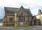
| Robertson Mausoleum, Old High Churchyard, Church Street |
|
|
|
57°28′48″N 4°13′43″W / 57.480118°N 4.228564°W / 57.480118; -4.228564 (Robertson Mausoleum, Old High Churchyard, Church Street) |
Category B |
35180 |
.jpg) Upload another image
|
| 115 Church Street |
|
|
|
57°28′49″N 4°13′42″W / 57.480147°N 4.228432°W / 57.480147; -4.228432 (115 Church Street) |
Category B |
35181 |
|
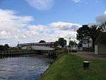
| Clachnaharry Road, Canal Workshops, Clachnaharry Lock |
|
|
|
57°29′19″N 4°15′19″W / 57.48869°N 4.25535°W / 57.48869; -4.25535 (Clachnaharry Road, Canal Workshops, Clachnaharry Lock) |
Category B |
35191 |
|
| Culduthel Road, Hedgefield Hostel And Stable Block, Walled Garden |
|
|
|
57°28′10″N 4°13′09″W / 57.46951°N 4.219179°W / 57.46951; -4.219179 (Culduthel Road, Hedgefield Hostel And Stable Block, Walled Garden) |
Category B |
35200 |
|
| Academy Street, Union Street, Church Street And Queensgate, Market Arcade And New Market |
|
|
|
57°28′45″N 4°13′29″W / 57.479253°N 4.224641°W / 57.479253; -4.224641 (Academy Street, Union Street, Church Street And Queensgate, Market Arcade And New Market) |
Category B |
35118 |
|
| 92 And 94 Academy Street |
|
|
|
57°28′49″N 4°13′36″W / 57.48041°N 4.22678°W / 57.48041; -4.22678 (92 And 94 Academy Street) |
Category B |
35124 |
|
| East Parish Church, Academy Street |
|
|
|
57°28′49″N 4°13′33″W / 57.480176°N 4.225815°W / 57.480176; -4.225815 (East Parish Church, Academy Street) |
Category B |
35125 |
 Upload another image
|
| 1-10 (Inclusive Numbers) And 12 Victoria Terrace |
|
|
|
57°28′51″N 4°12′45″W / 57.480768°N 4.212572°W / 57.480768; -4.212572 (1-10 (Inclusive Numbers) And 12 Victoria Terrace) |
Category C(S) |
47971 |
|
| Academy Street, Inverness Station, Lochgorm Works |
|
|
|
57°28′53″N 4°13′16″W / 57.481391°N 4.221101°W / 57.481391; -4.221101 (Academy Street, Inverness Station, Lochgorm Works) |
Category B |
50928 |
|
| 1 Grant Street, Argyle Bar |
|
|
|
57°29′03″N 4°14′00″W / 57.48413°N 4.233413°W / 57.48413; -4.233413 (1 Grant Street, Argyle Bar) |
Category C(S) |
43489 |
|
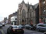
| Cathedral Church Of St Andrew (Episcopal), Ness Walk |
|
|
|
57°28′28″N 4°13′45″W / 57.474465°N 4.229154°W / 57.474465; -4.229154 (Cathedral Church Of St Andrew (Episcopal), Ness Walk) |
Category A |
35330 |
.jpg) Upload another image
See more images
|
| Ness Walk, Royal Northern Infirmary, Former Nurses' Home |
|
|
|
57°28′17″N 4°13′49″W / 57.471415°N 4.230402°W / 57.471415; -4.230402 (Ness Walk, Royal Northern Infirmary, Former Nurses' Home) |
Category B |
35333 |
.jpg) Upload another image
|
| Ness Walk, And Ballifeary Lane, Springfield Hotel |
|
|
|
57°28′11″N 4°13′51″W / 57.469682°N 4.230814°W / 57.469682; -4.230814 (Ness Walk, And Ballifeary Lane, Springfield Hotel) |
Category B |
35334 |
|
| Old Edinburgh Road, Lamburn |
|
|
|
57°27′28″N 4°13′07″W / 57.457734°N 4.218482°W / 57.457734; -4.218482 (Old Edinburgh Road, Lamburn) |
Category C(S) |
35337 |
|
| 48 Southside Road |
|
|
|
57°28′19″N 4°13′17″W / 57.471924°N 4.221427°W / 57.471924; -4.221427 (48 Southside Road) |
Category C(S) |
35354 |
|
| Telford Road, Merkinch Primary School, School House And Retaining Railings |
|
|
|
57°29′00″N 4°14′21″W / 57.483445°N 4.23906°W / 57.483445; -4.23906 (Telford Road, Merkinch Primary School, School House And Retaining Railings) |
Category B |
35363 |
|
| 21-39 Union Street (Odd Numbers Only), 2 Drummond Street And 24 Church Street Douglas Hotel |
|
|
|
57°28′43″N 4°13′31″W / 57.478503°N 4.22538°W / 57.478503; -4.22538 (21-39 Union Street (Odd Numbers Only), 2 Drummond Street And 24 Church Street Douglas Hotel) |
Category B |
35368 |
|
| 38-46 (Even Numbers Only) Union Street |
|
|
|
57°28′44″N 4°13′34″W / 57.478904°N 4.226105°W / 57.478904; -4.226105 (38-46 (Even Numbers Only) Union Street) |
Category B |
35370 |
|
| 50 Union Street And 26 Church Street Bank Of Scotland |
|
|
|
57°28′43″N 4°13′34″W / 57.478561°N 4.226184°W / 57.478561; -4.226184 (50 Union Street And 26 Church Street Bank Of Scotland) |
Category B |
35371 |
|
| 5 And 6 Viewplace And Garden Wall |
|
|
|
57°28′29″N 4°13′31″W / 57.474776°N 4.22527°W / 57.474776; -4.22527 (5 And 6 Viewplace And Garden Wall) |
Category B |
35374 |
|
| 4 Wells Street |
|
|
|
57°28′51″N 4°14′05″W / 57.480728°N 4.234724°W / 57.480728; -4.234724 (4 Wells Street) |
Category C(S) |
35386 |
|
| 13-19 (Odd Numbers Only) Young Street |
|
|
|
57°28′35″N 4°13′44″W / 57.476508°N 4.228945°W / 57.476508; -4.228945 (13-19 (Odd Numbers Only) Young Street) |
Category C(S) |
35389 |
|
| 20 Douglas Row |
|
|
|
57°28′48″N 4°13′49″W / 57.480124°N 4.230283°W / 57.480124; -4.230283 (20 Douglas Row) |
Category B |
35233 |
|
| 22 And 23 Douglas Row |
|
|
|
57°28′48″N 4°13′48″W / 57.480031°N 4.229943°W / 57.480031; -4.229943 (22 And 23 Douglas Row) |
Category B |
35235 |
|
| 3 Huntly Place |
|
|
|
57°28′54″N 4°14′07″W / 57.481634°N 4.235296°W / 57.481634; -4.235296 (3 Huntly Place) |
Category B |
35264 |
|
| 16 And 17 Huntly Street |
|
|
|
57°28′39″N 4°13′45″W / 57.477447°N 4.229202°W / 57.477447; -4.229202 (16 And 17 Huntly Street) |
Category B |
35270 |
|
| Huntly Street, Former Queen Street Church |
|
|
|
57°28′44″N 4°13′54″W / 57.478968°N 4.231597°W / 57.478968; -4.231597 (Huntly Street, Former Queen Street Church) |
Category C(S) |
35277 |
|
| 21 Island Bank Road, Ach-An-Eas |
|
|
|
57°27′53″N 4°13′38″W / 57.464797°N 4.227114°W / 57.464797; -4.227114 (21 Island Bank Road, Ach-An-Eas) |
Category C(S) |
35291 |
|
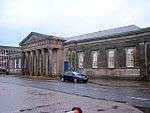
| Former Farraline Park School (Inverness Public Library), Margaret Street |
|
|
|
57°28′52″N 4°13′28″W / 57.481043°N 4.224517°W / 57.481043; -4.224517 (Former Farraline Park School (Inverness Public Library), Margaret Street) |
Category A |
35311 |
 Upload another image
See more images
|
| 60 (Maryfield) And 62 Midmills Road |
|
|
|
57°28′37″N 4°12′36″W / 57.476808°N 4.209881°W / 57.476808; -4.209881 (60 (Maryfield) And 62 Midmills Road) |
Category B |
35313 |
|
| 12 Muirtown Street |
|
|
|
57°28′47″N 4°14′05″W / 57.479677°N 4.234693°W / 57.479677; -4.234693 (12 Muirtown Street) |
Category C(S) |
35318 |
|
| 14 Ness Bank, Struan |
|
|
|
57°28′25″N 4°13′36″W / 57.473673°N 4.226687°W / 57.473673; -4.226687 (14 Ness Bank, Struan) |
Category C(S) |
35323 |
|
| 38, 40, 42 And 44 Academy Street |
|
|
|
57°28′47″N 4°13′30″W / 57.479668°N 4.225034°W / 57.479668; -4.225034 (38, 40, 42 And 44 Academy Street) |
Category C(S) |
35126 |
|
| 28-34 (Even Nos Only) Academy Street |
|
|
|
57°28′46″N 4°13′28″W / 57.479384°N 4.224366°W / 57.479384; -4.224366 (28-34 (Even Nos Only) Academy Street) |
Category A |
35127 |
|
| 1-9 Ardross Street (All Numbers) |
|
|
|
57°28′30″N 4°13′47″W / 57.474995°N 4.229636°W / 57.474995; -4.229636 (1-9 Ardross Street (All Numbers)) |
Category B |
35134 |
|
| 13 Ardross Street |
|
|
|
57°28′30″N 4°13′51″W / 57.474877°N 4.230763°W / 57.474877; -4.230763 (13 Ardross Street) |
Category C(S) |
35137 |
|
| 1 Bishop's Road |
|
|
|
57°28′21″N 4°13′48″W / 57.472546°N 4.229954°W / 57.472546; -4.229954 (1 Bishop's Road) |
Category B |
35152 |
|
| 4-14 (Even Nos Only) Bridge Street |
|
|
|
57°28′39″N 4°13′34″W / 57.477556°N 4.226073°W / 57.477556; -4.226073 (4-14 (Even Nos Only) Bridge Street) |
Category B |
35154 |
|
| 27 Broadstone Park Oakdene |
|
|
|
57°28′38″N 4°12′48″W / 57.47719°N 4.213207°W / 57.47719; -4.213207 (27 Broadstone Park Oakdene) |
Category B |
35155 |
|
| 101 And 103 Castle Street |
|
|
|
57°28′31″N 4°13′30″W / 57.475286°N 4.224884°W / 57.475286; -4.224884 (101 And 103 Castle Street) |
Category C(S) |
35165 |
|
| 105, 107 Church Street |
|
|
|
57°28′48″N 4°13′41″W / 57.479893°N 4.2281°W / 57.479893; -4.2281 (105, 107 Church Street) |
Category C(S) |
35176 |
|
| Dunbar's Hospital, 86 and 88 Church Street |
|
|
|
57°28′48″N 4°13′40″W / 57.480013°N 4.22789°W / 57.480013; -4.22789 (Dunbar's Hospital, 86 and 88 Church Street) |
Category A |
35184 |
 Upload another image
See more images
|
| 84 Church Street Bow Court |
|
|
|
57°28′47″N 4°13′39″W / 57.479793°N 4.22761°W / 57.479793; -4.22761 (84 Church Street Bow Court) |
Category B |
35185 |
|
| 82 Church Street |
|
|
|
57°28′47″N 4°13′39″W / 57.479723°N 4.227556°W / 57.479723; -4.227556 (82 Church Street) |
Category B |
35186 |
|
| 12 And 14 Crown Avenue, Crown House |
|
|
|
57°28′43″N 4°13′08″W / 57.478673°N 4.218801°W / 57.478673; -4.218801 (12 And 14 Crown Avenue, Crown House) |
Category B |
35194 |
|
| 99-107 (Odd Numbers Only) Academy Street |
|
|
|
57°28′50″N 4°13′41″W / 57.480514°N 4.228038°W / 57.480514; -4.228038 (99-107 (Odd Numbers Only) Academy Street) |
Category B |
35120 |
|
| 1-11 (Odd Nos) Tomnahurich Street |
|
|
|
57°28′35″N 4°13′46″W / 57.476427°N 4.229473°W / 57.476427; -4.229473 (1-11 (Odd Nos) Tomnahurich Street) |
Category C(S) |
46542 |
|
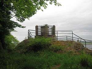
| Clan Battle Monument, Clachnaharry |
|
|
|
57°29′17″N 4°15′40″W / 57.487956°N 4.261211°W / 57.487956; -4.261211 (Clan Battle Monument, Clachnaharry) |
Category C(S) |
48262 |
 Upload another image
|
| Mackintosh Road, RAF Filter Block (The Bunker) |
|
|
|
57°28′53″N 4°11′56″W / 57.481347°N 4.199011°W / 57.481347; -4.199011 (Mackintosh Road, RAF Filter Block (The Bunker)) |
Category B |
49181 |
|
| Mayfield Road, The Isobel Fraser Home Of Rest |
|
|
|
57°28′21″N 4°13′19″W / 57.472496°N 4.222079°W / 57.472496; -4.222079 (Mayfield Road, The Isobel Fraser Home Of Rest) |
Category B |
43490 |
|
| 1 To 6 (Inclusive Nos) Ness Walk And 1 And 3 Young Street |
|
|
|
57°28′35″N 4°13′42″W / 57.476518°N 4.228411°W / 57.476518; -4.228411 (1 To 6 (Inclusive Nos) Ness Walk And 1 And 3 Young Street) |
Category B |
35327 |
|
| Eden Court (former Bishop's Palace only), Ness Walk |
|
|
|
57°28′24″N 4°13′51″W / 57.473365°N 4.230871°W / 57.473365; -4.230871 (Eden Court (former Bishop's Palace only), Ness Walk) |
Category B |
35331 |
.jpg) Upload another image
See more images
|
| Old Mill Lane, Culcabock House |
|
|
|
57°28′05″N 4°12′20″W / 57.468078°N 4.205535°W / 57.468078; -4.205535 (Old Mill Lane, Culcabock House) |
Category B |
35339 |
|
| Drakies House, Perth Road and Culcabock Avenue |
|
|
|
57°28′14″N 4°11′58″W / 57.470523°N 4.199312°W / 57.470523; -4.199312 (Drakies House, Perth Road and Culcabock Avenue) |
Category B |
35341 |
.jpg) Upload another image
|
| Stratherrick Road, Lodge, Drummond Hill |
|
|
|
57°27′28″N 4°13′59″W / 57.457675°N 4.232966°W / 57.457675; -4.232966 (Stratherrick Road, Lodge, Drummond Hill) |
Category B |
35360 |
|
| Stratherrick Road, Bellevue |
|
|
|
57°27′33″N 4°13′54″W / 57.45927°N 4.23173°W / 57.45927; -4.23173 (Stratherrick Road, Bellevue) |
Category B |
35361 |
|
| 24-38 (Even Numbers Only) Telford Street |
|
|
|
57°28′51″N 4°14′23″W / 57.48097°N 4.239793°W / 57.48097; -4.239793 (24-38 (Even Numbers Only) Telford Street) |
Category B |
35365 |
|
| 19 Union Street, And 1-9 (Odd Numbers Only) Drummond Street, Royal Bank Of Scotland |
|
|
|
57°28′43″N 4°13′30″W / 57.478599°N 4.225052°W / 57.478599; -4.225052 (19 Union Street, And 1-9 (Odd Numbers Only) Drummond Street, Royal Bank Of Scotland) |
Category B |
35367 |
|
| 10-24 (Even Numbers Only), Union Street |
|
|
|
57°28′44″N 4°13′30″W / 57.478939°N 4.225106°W / 57.478939; -4.225106 (10-24 (Even Numbers Only), Union Street) |
Category B |
35369 |
|
| 1 And 2 Viewplace And Castle Street And Culduthel Road |
|
|
|
57°28′30″N 4°13′31″W / 57.474994°N 4.225166°W / 57.474994; -4.225166 (1 And 2 Viewplace And Castle Street And Culduthel Road) |
Category C(S) |
35372 |
|
| 44 Wells Street |
|
|
|
57°28′49″N 4°14′12″W / 57.480404°N 4.236789°W / 57.480404; -4.236789 (44 Wells Street) |
Category C(S) |
35377 |
|
| 40 Wells Street |
|
|
|
57°28′49″N 4°14′12″W / 57.480408°N 4.236539°W / 57.480408; -4.236539 (40 Wells Street) |
Category C(S) |
35379 |
|
| 22 Culduthel Road, Heatherly House |
|
|
|
57°28′11″N 4°13′26″W / 57.469699°N 4.22376°W / 57.469699; -4.22376 (22 Culduthel Road, Heatherly House) |
Category B |
35210 |
|
| 18 Culduthel Road |
|
|
|
57°28′15″N 4°13′26″W / 57.470947°N 4.223803°W / 57.470947; -4.223803 (18 Culduthel Road) |
Category B |
35212 |
|
| 10 Douglas Row |
|
|
|
57°28′50″N 4°13′53″W / 57.4806°N 4.231296°W / 57.4806; -4.231296 (10 Douglas Row) |
Category B |
35223 |
|
| 14 Douglas Row |
|
|
|
57°28′49″N 4°13′51″W / 57.480374°N 4.230848°W / 57.480374; -4.230848 (14 Douglas Row) |
Category B |
35227 |
|
| 4 Eastgate |
|
|
|
57°28′41″N 4°13′21″W / 57.478094°N 4.222586°W / 57.478094; -4.222586 (4 Eastgate) |
Category C(S) |
35241 |
|
| 28 And 30 High Street |
|
|
|
57°28′39″N 4°13′26″W / 57.477622°N 4.223858°W / 57.477622; -4.223858 (28 And 30 High Street) |
Category B |
35257 |
|
| St Mary's RC Presbytery, 30 Huntly Street |
|
|
|
57°28′40″N 4°13′47″W / 57.477913°N 4.229798°W / 57.477913; -4.229798 (St Mary's RC Presbytery, 30 Huntly Street) |
Category B |
35271 |
|
| St Mary's RC Church, Huntly Street |
|
|
|
57°28′40″N 4°13′48″W / 57.47789°N 4.23008°W / 57.47789; -4.23008 (St Mary's RC Church, Huntly Street) |
Category A |
35272 |
.jpg) Upload another image
|
| Balnain House, Huntly Street |
|
|
|
57°28′44″N 4°13′52″W / 57.478759°N 4.231234°W / 57.478759; -4.231234 (Balnain House, Huntly Street) |
Category A |
35276 |
 Upload another image
|
| 15 Island Bank Road |
|
|
|
57°27′57″N 4°13′35″W / 57.465921°N 4.226516°W / 57.465921; -4.226516 (15 Island Bank Road) |
Category C(S) |
35288 |
|
| 4 Ladies Walk |
|
|
|
57°28′11″N 4°13′40″W / 57.469702°N 4.22768°W / 57.469702; -4.22768 (4 Ladies Walk) |
Category B |
35305 |
|
| Inverness High School, Off Montague Row |
|
|
|
57°28′33″N 4°14′15″W / 57.475773°N 4.23749°W / 57.475773; -4.23749 (Inverness High School, Off Montague Row) |
Category B |
35314 |
 Upload another image
|
| 10 Ness Bank (Including Former Number 12 Ness Bank) |
|
|
|
57°28′26″N 4°13′35″W / 57.473976°N 4.226305°W / 57.473976; -4.226305 (10 Ness Bank (Including Former Number 12 Ness Bank)) |
Category C(S) |
35321 |
|
| 16, 17 And 18 Ness Bank |
|
|
|
57°28′24″N 4°13′37″W / 57.4734°N 4.226854°W / 57.4734; -4.226854 (16, 17 And 18 Ness Bank) |
Category B |
35325 |
|
| 8 And 10 Academy Street |
|
|
|
57°28′45″N 4°13′24″W / 57.479089°N 4.22323°W / 57.479089; -4.22323 (8 And 10 Academy Street) |
Category C(S) |
35130 |
|
| 7A,9-13 Ardconnel Terrace (Odd Nos)And 1-6 (Inclusive) Tulloch Buildings |
|
|
|
57°28′40″N 4°13′16″W / 57.477798°N 4.221017°W / 57.477798; -4.221017 (7A,9-13 Ardconnel Terrace (Odd Nos)And 1-6 (Inclusive) Tulloch Buildings) |
Category B |
35133 |
|
| 1-6 (All Nos) Ardross Terrace |
|
|
|
57°28′30″N 4°13′43″W / 57.475103°N 4.228659°W / 57.475103; -4.228659 (1-6 (All Nos) Ardross Terrace) |
Category B |
35145 |
.jpg) Upload another image
|
| Free North Church, Bank Street |
|
|
|
57°28′46″N 4°13′43″W / 57.479379°N 4.228703°W / 57.479379; -4.228703 (Free North Church, Bank Street) |
Category B |
35151 |
.jpg) Upload another image
See more images
|
| 41 And 45 Castle Street |
|
|
|
57°28′36″N 4°13′27″W / 57.476717°N 4.22422°W / 57.476717; -4.22422 (41 And 45 Castle Street) |
Category B |
35161 |
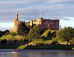
|
| Sheriff Court and Police Station (Inverness Castle), Castle Hill, Castle Wynd |
|
|
|
57°28′34″N 4°13′32″W / 57.476165°N 4.225488°W / 57.476165; -4.225488 (Sheriff Court and Police Station (Inverness Castle), Castle Hill, Castle Wynd) |
Category A |
35166 |
 Upload another image
See more images
|
| 109 Church Street |
|
|
|
57°28′48″N 4°13′42″W / 57.479962°N 4.228238°W / 57.479962; -4.228238 (109 Church Street) |
Category B |
35177 |
|
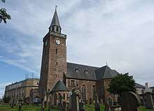
| Old High Church, Church Street |
|
|
|
57°28′49″N 4°13′44″W / 57.480141°N 4.228799°W / 57.480141; -4.228799 (Old High Church, Church Street) |
Category A |
35179 |
 Upload another image
See more images
|
| 87 Culduthel Road Cluny House |
|
|
|
57°27′51″N 4°12′59″W / 57.464043°N 4.216347°W / 57.464043; -4.216347 (87 Culduthel Road Cluny House) |
Category B |
35202 |
|
| 145 Culduthel Road |
|
|
|
57°27′28″N 4°13′12″W / 57.457867°N 4.220074°W / 57.457867; -4.220074 (145 Culduthel Road) |
Category B |
35205 |
|
| 96-104 (Even Numbers Only) Academy Street And 2 Rose Street |
|
|
|
57°28′50″N 4°13′38″W / 57.480582°N 4.227224°W / 57.480582; -4.227224 (96-104 (Even Numbers Only) Academy Street And 2 Rose Street) |
Category B |
35123 |
|
| Clachnaharry Swing Bridge and Signal Box |
|
|
|
57°29′22″N 4°15′23″W / 57.489409°N 4.256328°W / 57.489409; -4.256328 (Clachnaharry Swing Bridge and Signal Box) |
Category B |
46540 |
 Upload another image
See more images
|
| 20 Baron Taylor's Street |
|
|
|
57°28′42″N 4°13′29″W / 57.478317°N 4.224735°W / 57.478317; -4.224735 (20 Baron Taylor's Street) |
Category C(S) |
46541 |
|
| Viewhill (Former Inverness Youth Hostel), including gateways, gatepiers and boundary walls, 1 Old Edinburgh Road at Gordon Terrace |
|
|
|
57°28′29″N 4°13′27″W / 57.474623°N 4.22426°W / 57.474623; -4.22426 (Viewhill (Former Inverness Youth Hostel), including gateways, gatepiers and boundary walls, 1 Old Edinburgh Road at Gordon Terrace) |
Category B |
47604 |
 Upload another image
|
| 26 Oak Avenue (Old Drummond) |
|
|
|
57°27′41″N 4°13′31″W / 57.461514°N 4.225247°W / 57.461514; -4.225247 (26 Oak Avenue (Old Drummond)) |
Category B |
35336 |
|
| 32 Wells Street |
|
|
|
57°28′50″N 4°14′10″W / 57.480504°N 4.236178°W / 57.480504; -4.236178 (32 Wells Street) |
Category C(S) |
35383 |
|
| 16 Douglas Row |
|
|
|
57°28′49″N 4°13′50″W / 57.480306°N 4.230661°W / 57.480306; -4.230661 (16 Douglas Row) |
Category B |
35229 |
|
| 28 Friars' Lane |
|
|
|
57°28′48″N 4°13′47″W / 57.48006°N 4.229812°W / 57.48006; -4.229812 (28 Friars' Lane) |
Category B |
35245 |
|
| 54-60 (Even Numbers Only) High Street |
|
|
|
57°28′47″N 4°13′24″W / 57.479717°N 4.223285°W / 57.479717; -4.223285 (54-60 (Even Numbers Only) High Street) |
Category A |
35259 |
|
| 8 And 9 Huntly Place |
|
|
|
57°28′56″N 4°14′07″W / 57.48212°N 4.235292°W / 57.48212; -4.235292 (8 And 9 Huntly Place) |
Category B |
35267 |
|
| 45-48 Huntly Street (All Numbers) |
|
|
|
57°28′45″N 4°13′55″W / 57.479233°N 4.23188°W / 57.479233; -4.23188 (45-48 Huntly Street (All Numbers)) |
Category B |
35279 |
|
| 27 Island Bank Road |
|
|
|
57°27′43″N 4°13′49″W / 57.462082°N 4.230234°W / 57.462082; -4.230234 (27 Island Bank Road) |
Category C(S) |
35292 |
|
| 42 And 44 Island Bank Road |
|
|
|
57°27′38″N 4°14′02″W / 57.460417°N 4.23395°W / 57.460417; -4.23395 (42 And 44 Island Bank Road) |
Category C(S) |
35297 |
|
| Ladies Walk, War Memorial |
|
|
|
57°28′16″N 4°13′41″W / 57.471099°N 4.227948°W / 57.471099; -4.227948 (Ladies Walk, War Memorial) |
Category C(S) |
35309 |
|
| 1 And 3 Market Brae |
|
|
|
57°28′41″N 4°13′21″W / 57.478021°N 4.222631°W / 57.478021; -4.222631 (1 And 3 Market Brae) |
Category B |
35312 |
|
| 2 Moray Park, Island Bank |
|
|
|
57°28′16″N 4°13′37″W / 57.471046°N 4.226877°W / 57.471046; -4.226877 (2 Moray Park, Island Bank) |
Category B |
35315 |
|
| 12 Ness Bank (Formerly Number 13 Ness Bank) |
|
|
|
57°28′25″N 4°13′36″W / 57.473738°N 4.226574°W / 57.473738; -4.226574 (12 Ness Bank (Formerly Number 13 Ness Bank)) |
Category C(S) |
35322 |
|
| Academy Street, Monument To 79th Queen`s Own Cameron Highlanders Killed In Egypt And The Sudan(1882-1887) |
|
|
|
57°28′45″N 4°13′27″W / 57.479262°N 4.224125°W / 57.479262; -4.224125 (Academy Street, Monument To 79th Queen`s Own Cameron Highlanders Killed In Egypt And The Sudan(1882-1887)) |
Category C(S) |
35128 |
 Upload another image
See more images
|
| 13 Annfield Road, Lethington |
|
|
|
57°28′20″N 4°12′44″W / 57.472148°N 4.212218°W / 57.472148; -4.212218 (13 Annfield Road, Lethington) |
Category B |
35132 |
|
| 15 Ardross Street |
|
|
|
57°28′29″N 4°13′54″W / 57.474789°N 4.231675°W / 57.474789; -4.231675 (15 Ardross Street) |
Category B |
35139 |
|
| 18 Ardross Street |
|
|
|
57°28′29″N 4°13′57″W / 57.474684°N 4.232503°W / 57.474684; -4.232503 (18 Ardross Street) |
Category C(S) |
35142 |
|
| 47 And 49 Castle Street |
|
|
|
57°28′36″N 4°13′26″W / 57.476605°N 4.223997°W / 57.476605; -4.223997 (47 And 49 Castle Street) |
Category B |
35162 |
|
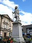
| Statue of Flora Macdonald, Castle Hill, Castle Wynd |
|
|
|
57°28′33″N 4°13′32″W / 57.475868°N 4.225503°W / 57.475868; -4.225503 (Statue of Flora Macdonald, Castle Hill, Castle Wynd) |
Category C(S) |
35167 |
 Upload another image
See more images
|
| 24 (Ironside) And 26 Crown Drive |
|
|
|
57°28′48″N 4°12′50″W / 57.480034°N 4.213946°W / 57.480034; -4.213946 (24 (Ironside) And 26 Crown Drive) |
Category B |
35195 |
|
| 5 Culduthel Road Ardkeen Tower |
|
|
|
57°28′27″N 4°13′28″W / 57.474073°N 4.22436°W / 57.474073; -4.22436 (5 Culduthel Road Ardkeen Tower) |
Category B |
35196 |
|
| Culduthel Road, Altnaskiach House |
|
|
|
57°28′02″N 4°13′28″W / 57.467307°N 4.224365°W / 57.467307; -4.224365 (Culduthel Road, Altnaskiach House) |
Category B |
35201 |
|
| 89 Culduthel Road |
|
|
|
57°27′49″N 4°13′00″W / 57.463579°N 4.216652°W / 57.463579; -4.216652 (89 Culduthel Road) |
Category B |
35203 |
|
| 135 Culduthel Road |
|
|
|
57°27′33″N 4°13′09″W / 57.459088°N 4.219148°W / 57.459088; -4.219148 (135 Culduthel Road) |
Category B |
35204 |
|
| 68 Culduthel Road |
|
|
|
57°27′55″N 4°13′00″W / 57.465356°N 4.216793°W / 57.465356; -4.216793 (68 Culduthel Road) |
Category B |
35206 |
|
| 48 Culduthel Road |
|
|
|
57°27′59″N 4°13′07″W / 57.466269°N 4.218516°W / 57.466269; -4.218516 (48 Culduthel Road) |
Category B |
35207 |
|
| 1-9 (Odd Numbers Only) Academy Street |
|
|
|
57°28′44″N 4°13′26″W / 57.478852°N 4.223916°W / 57.478852; -4.223916 (1-9 (Odd Numbers Only) Academy Street) |
Category B |
35116 |
|
| 91-97 (Odd Numbers Only) Academy Street |
|
|
|
57°28′50″N 4°13′41″W / 57.480479°N 4.227952°W / 57.480479; -4.227952 (91-97 (Odd Numbers Only) Academy Street) |
Category B |
35119 |
|
| 106, 108, 110 Academy Street And 1, 3, And 5 Rose Street (The Phoenix Bar) |
|
|
|
57°28′51″N 4°13′39″W / 57.48081°N 4.227572°W / 57.48081; -4.227572 (106, 108, 110 Academy Street And 1, 3, And 5 Rose Street (The Phoenix Bar)) |
Category B |
35122 |
|
| 60-66 Academy Street |
|
|
|
57°28′48″N 4°13′32″W / 57.48002°N 4.225455°W / 57.48002; -4.225455 (60-66 Academy Street) |
Category B |
43639 |
|
| Ivybank, 28 Old Edinburgh Road |
|
|
|
57°28′25″N 4°13′15″W / 57.473749°N 4.220854°W / 57.473749; -4.220854 (Ivybank, 28 Old Edinburgh Road) |
Category B |
43640 |
|
| Ness Walk, Royal Northern Infirmary And Tweedmouth Memorial Chapel |
|
|
|
57°28′15″N 4°13′51″W / 57.470699°N 4.230742°W / 57.470699; -4.230742 (Ness Walk, Royal Northern Infirmary And Tweedmouth Memorial Chapel) |
Category B |
35332 |
 Upload another image
|
| 2-10 (Even Numbers Only) Queensgate |
|
|
|
57°28′47″N 4°13′34″W / 57.479641°N 4.226066°W / 57.479641; -4.226066 (2-10 (Even Numbers Only) Queensgate) |
Category B |
35346 |
|
| Stephen's Street, Royal Academy |
|
|
|
57°28′40″N 4°13′06″W / 57.477901°N 4.218237°W / 57.477901; -4.218237 (Stephen's Street, Royal Academy) |
Category B |
35355 |
|
| Stratherrick Road, Lochardil Hotel |
|
|
|
57°27′22″N 4°14′03″W / 57.45599°N 4.234264°W / 57.45599; -4.234264 (Stratherrick Road, Lochardil Hotel) |
Category B |
35356 |
|
| Stratherrick Road, Drummond Hill |
|
|
|
57°27′32″N 4°13′58″W / 57.459017°N 4.232814°W / 57.459017; -4.232814 (Stratherrick Road, Drummond Hill) |
Category B |
35359 |
|
| 10 And 11 Viewplace |
|
|
|
57°28′28″N 4°13′31″W / 57.474523°N 4.225338°W / 57.474523; -4.225338 (10 And 11 Viewplace) |
Category C(S) |
35376 |
|
| 34 Wells Street |
|
|
|
57°28′50″N 4°14′11″W / 57.480493°N 4.236294°W / 57.480493; -4.236294 (34 Wells Street) |
Category C(S) |
35382 |
|
| 8 Wells Street |
|
|
|
57°28′51″N 4°14′06″W / 57.480698°N 4.234872°W / 57.480698; -4.234872 (8 Wells Street) |
Category C(S) |
35385 |
|
| 20 Culduthel Road Beechlawn |
|
|
|
57°28′14″N 4°13′25″W / 57.47062°N 4.223499°W / 57.47062; -4.223499 (20 Culduthel Road Beechlawn) |
Category B |
35211 |
|
| 3 Douglas Row |
|
|
|
57°28′51″N 4°13′54″W / 57.480861°N 4.231796°W / 57.480861; -4.231796 (3 Douglas Row) |
Category B |
35218 |
|
| 13 Douglas Row |
|
|
|
57°28′50″N 4°13′51″W / 57.480444°N 4.230953°W / 57.480444; -4.230953 (13 Douglas Row) |
Category B |
35226 |
|
| 24 Douglas Row |
|
|
|
57°28′48″N 4°13′48″W / 57.480005°N 4.229892°W / 57.480005; -4.229892 (24 Douglas Row) |
Category B |
35236 |
|
| 3 Drummond Crescent |
|
|
|
57°27′50″N 4°13′37″W / 57.463982°N 4.226931°W / 57.463982; -4.226931 (3 Drummond Crescent) |
Category B |
35238 |
|
| 13 Drummond Crescent (Brae Rannoch) And Cottage |
|
|
|
57°27′40″N 4°13′41″W / 57.461096°N 4.228073°W / 57.461096; -4.228073 (13 Drummond Crescent (Brae Rannoch) And Cottage) |
Category B |
35240 |
|
| 49 Huntly Street |
|
|
|
57°28′46″N 4°13′56″W / 57.479407°N 4.232207°W / 57.479407; -4.232207 (49 Huntly Street) |
Category C(S) |
35280 |
|
| 2 Inglis Street And 4 Inglis Street |
|
|
|
57°28′42″N 4°13′22″W / 57.478342°N 4.222801°W / 57.478342; -4.222801 (2 Inglis Street And 4 Inglis Street) |
Category B |
35282 |
|
| 13 Island Bank Road, Woodfield |
|
|
|
57°28′00″N 4°13′34″W / 57.466547°N 4.226187°W / 57.466547; -4.226187 (13 Island Bank Road, Woodfield) |
Category C(S) |
35287 |
|
| 17 Island Bank Road, Riverdale |
|
|
|
57°27′56″N 4°13′36″W / 57.465614°N 4.22663°W / 57.465614; -4.22663 (17 Island Bank Road, Riverdale) |
Category B |
35289 |
|
| 31 Island Bank Road, Rossal |
|
|
|
57°27′41″N 4°13′50″W / 57.461341°N 4.230455°W / 57.461341; -4.230455 (31 Island Bank Road, Rossal) |
Category B |
35294 |
|
| 12 Huntly Place, (Formerly Known As 78 Kessock Street Upper) |
|
|
|
57°28′57″N 4°14′07″W / 57.482606°N 4.235222°W / 57.482606; -4.235222 (12 Huntly Place, (Formerly Known As 78 Kessock Street Upper)) |
Category C(S) |
35300 |
|
| 2 Ladies Walk |
|
|
|
57°28′12″N 4°13′40″W / 57.470016°N 4.227682°W / 57.470016; -4.227682 (2 Ladies Walk) |
Category C(S) |
35303 |
|
| Ladies Walk, Forbes Fountain |
|
|
|
57°28′09″N 4°13′39″W / 57.469029°N 4.227622°W / 57.469029; -4.227622 (Ladies Walk, Forbes Fountain) |
Category C(S) |
35310 |
|
| 15 Ness Bank |
|
|
|
57°28′25″N 4°13′36″W / 57.473609°N 4.226733°W / 57.473609; -4.226733 (15 Ness Bank) |
Category C(S) |
35324 |
|
| 14 Ardross Street |
|
|
|
57°28′30″N 4°13′53″W / 57.474893°N 4.231348°W / 57.474893; -4.231348 (14 Ardross Street) |
Category B |
35138 |
|
| 17 Ardross Street |
|
|
|
57°28′29″N 4°13′56″W / 57.474743°N 4.232206°W / 57.474743; -4.232206 (17 Ardross Street) |
Category C(S) |
35141 |
|
| 19 Ardross Street |
|
|
|
57°28′29″N 4°13′58″W / 57.474699°N 4.232671°W / 57.474699; -4.232671 (19 Ardross Street) |
Category C(S) |
35143 |
|
| Bank Street And Fraser Street, St Columba High Church |
|
|
|
57°28′43″N 4°13′39″W / 57.478725°N 4.227545°W / 57.478725; -4.227545 (Bank Street And Fraser Street, St Columba High Church) |
Category B |
35150 |
|
| Thistle Inn, Celt Street |
|
|
|
57°28′46″N 4°14′01″W / 57.479308°N 4.233736°W / 57.479308; -4.233736 (Thistle Inn, Celt Street) |
Category C(S) |
35169 |
%2C_19_Celt_Street_(geograph_2105958).jpg) Upload another image
|
| 43, 45, 47 Church Street |
|
|
|
57°28′42″N 4°13′36″W / 57.478452°N 4.226761°W / 57.478452; -4.226761 (43, 45, 47 Church Street) |
Category B |
35173 |
|
| Abertarff House, 71 Church Street |
|
|
|
57°28′45″N 4°13′39″W / 57.479174°N 4.227556°W / 57.479174; -4.227556 (Abertarff House, 71 Church Street) |
Category B |
35175 |
|
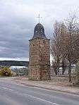
| Clachnaharry Road Tollhouse |
|
|
|
57°29′06″N 4°15′06″W / 57.48507°N 4.251756°W / 57.48507; -4.251756 (Clachnaharry Road Tollhouse) |
Category B |
35188 |
|
| Lock-Keeper's House And Store at Clachnaharry Sea Lock, Off Clachnaharry Road |
|
|
|
57°29′25″N 4°15′46″W / 57.490354°N 4.262794°W / 57.490354; -4.262794 (Lock-Keeper's House And Store at Clachnaharry Sea Lock, Off Clachnaharry Road) |
Category B |
35190 |
 Upload another image
|
| Cromwell Road, Clock Tower |
|
|
|
57°29′17″N 4°13′46″W / 57.488034°N 4.22958°W / 57.488034; -4.22958 (Cromwell Road, Clock Tower) |
Category B |
35193 |
 Upload another image
|
| 9 Culduthel Road |
|
|
|
57°28′23″N 4°13′25″W / 57.473115°N 4.223651°W / 57.473115; -4.223651 (9 Culduthel Road) |
Category C(S) |
35198 |
.jpg) Upload another image
|
| 15 Academy Street |
|
|
|
57°28′45″N 4°13′28″W / 57.479093°N 4.224532°W / 57.479093; -4.224532 (15 Academy Street) |
Category B |
35117 |
|
| Ness Walk, Royal Northern Infirmary, Porter's Lodge |
|
|
|
57°28′17″N 4°13′48″W / 57.471405°N 4.229951°W / 57.471405; -4.229951 (Ness Walk, Royal Northern Infirmary, Porter's Lodge) |
Category C(S) |
46408 |
|
| Ardross Street, Northern Meeting Park Pavilion Building And Boundary Walls |
|
|
|
57°28′29″N 4°13′51″W / 57.474597°N 4.230813°W / 57.474597; -4.230813 (Ardross Street, Northern Meeting Park Pavilion Building And Boundary Walls) |
Category B |
51129 |
|
| 42 Southside Road |
|
|
|
57°28′20″N 4°13′13″W / 57.472332°N 4.220184°W / 57.472332; -4.220184 (42 Southside Road) |
Category C(S) |
35351 |
|
| 44 Southside Road |
|
|
|
57°28′20″N 4°13′14″W / 57.472206°N 4.220694°W / 57.472206; -4.220694 (44 Southside Road) |
Category C(S) |
35352 |
|
| 14 Culduthel Road |
|
|
|
57°28′18″N 4°13′26″W / 57.471646°N 4.223895°W / 57.471646; -4.223895 (14 Culduthel Road) |
Category B |
35214 |
|
| 2 Douglas Row |
|
|
|
57°28′51″N 4°13′55″W / 57.480913°N 4.231866°W / 57.480913; -4.231866 (2 Douglas Row) |
Category B |
35217 |
|
| 4 Douglas Row |
|
|
|
57°28′51″N 4°13′54″W / 57.480826°N 4.231727°W / 57.480826; -4.231727 (4 Douglas Row) |
Category B |
35219 |
|
| 5 Douglas Row |
|
|
|
57°28′51″N 4°13′54″W / 57.480782°N 4.231674°W / 57.480782; -4.231674 (5 Douglas Row) |
Category B |
35220 |
|
| 2 Drummond Crescent, Rosedene |
|
|
|
57°27′50″N 4°13′41″W / 57.463816°N 4.228188°W / 57.463816; -4.228188 (2 Drummond Crescent, Rosedene) |
Category B |
35237 |
|
| 51-57 Grant Street (Odd Numbers Only) |
|
|
|
57°29′05″N 4°14′08″W / 57.484758°N 4.235487°W / 57.484758; -4.235487 (51-57 Grant Street (Odd Numbers Only)) |
Category B |
35246 |
|
| Bank of Scotland (former Caledonian Bank head office), 9 and 11 High Street |
|
|
|
57°28′40″N 4°13′30″W / 57.477843°N 4.225106°W / 57.477843; -4.225106 (Bank of Scotland (former Caledonian Bank head office), 9 and 11 High Street) |
Category A |
35251 |
.jpg) Upload another image
See more images
|
| 10 Huntly Place |
|
|
|
57°28′56″N 4°14′07″W / 57.482255°N 4.235251°W / 57.482255; -4.235251 (10 Huntly Place) |
Category C(S) |
35268 |
|
| Huntly Street, West Parish Church |
|
|
|
57°28′42″N 4°13′51″W / 57.478371°N 4.230826°W / 57.478371; -4.230826 (Huntly Street, West Parish Church) |
Category B |
35275 |
|
| Infirmary Bridge (Bridge From Ness Walk - Ness Bank) |
|
|
|
57°28′18″N 4°13′44″W / 57.471657°N 4.228916°W / 57.471657; -4.228916 (Infirmary Bridge (Bridge From Ness Walk - Ness Bank)) |
Category B |
35281 |
 Upload another image
See more images
|
| 19 Island Bank Road |
|
|
|
57°27′54″N 4°13′37″W / 57.465088°N 4.226882°W / 57.465088; -4.226882 (19 Island Bank Road) |
Category C(S) |
35290 |
|
| 1 Ladies Walk, Eileanach |
|
|
|
57°28′14″N 4°13′40″W / 57.470547°N 4.227664°W / 57.470547; -4.227664 (1 Ladies Walk, Eileanach) |
Category B |
35295 |
|
| 1A And 3 Annfield Road |
|
|
|
57°28′23″N 4°12′59″W / 57.472936°N 4.216485°W / 57.472936; -4.216485 (1A And 3 Annfield Road) |
Category B |
35131 |
|
| Ardross Street, Highland Regional Council Buildings |
|
|
|
57°28′27″N 4°13′59″W / 57.474154°N 4.232988°W / 57.474154; -4.232988 (Ardross Street, Highland Regional Council Buildings) |
Category C(S) |
35144 |
|
| 37 And 39 Castle Street |
|
|
|
57°28′37″N 4°13′26″W / 57.476842°N 4.223761°W / 57.476842; -4.223761 (37 And 39 Castle Street) |
Category B |
35160 |
|
| 92 And 94 Church Street |
|
|
|
57°28′49″N 4°13′41″W / 57.480147°N 4.227932°W / 57.480147; -4.227932 (92 And 94 Church Street) |
Category C(S) |
35183 |
|
| Clachnaharry Road, Muirtown Cottage |
|
|
|
57°29′01″N 4°14′56″W / 57.48374°N 4.248771°W / 57.48374; -4.248771 (Clachnaharry Road, Muirtown Cottage) |
Category B |
35187 |
|
| Clachnaharry Road 1 And 3 High Street |
|
|
|
57°29′19″N 4°15′24″W / 57.488659°N 4.256566°W / 57.488659; -4.256566 (Clachnaharry Road 1 And 3 High Street) |
Category B |
35192 |
|
| 24 Culduthel Road, Inglewood |
|
|
|
57°28′11″N 4°13′25″W / 57.469811°N 4.2235°W / 57.469811; -4.2235 (24 Culduthel Road, Inglewood) |
Category C(S) |
35209 |
|
| 30, 32, 34 Grant Street, Grant Street Welfare Hall |
|
|
|
57°29′05″N 4°14′03″W / 57.484689°N 4.234282°W / 57.484689; -4.234282 (30, 32, 34 Grant Street, Grant Street Welfare Hall) |
Category C(S) |
43488 |
|
| Ness Walk Columba Hotel |
|
|
|
57°28′35″N 4°13′43″W / 57.476254°N 4.228579°W / 57.476254; -4.228579 (Ness Walk Columba Hotel) |
Category B |
35328 |
|
| Ness Walk Palace Hotel |
|
|
|
57°28′33″N 4°13′41″W / 57.475955°N 4.228194°W / 57.475955; -4.228194 (Ness Walk Palace Hotel) |
Category B |
35329 |
|
| St Stephen's Church, Southside Road |
|
|
|
57°28′23″N 4°13′08″W / 57.473075°N 4.218779°W / 57.473075; -4.218779 (St Stephen's Church, Southside Road) |
Category B |
35349 |
.jpg) Upload another image
See more images
|
| Stratherrick Road, Lodge, Lochardil Hotel |
|
|
|
57°27′28″N 4°13′56″W / 57.457672°N 4.232132°W / 57.457672; -4.232132 (Stratherrick Road, Lodge, Lochardil Hotel) |
Category C(S) |
35357 |
|
| Stratherrick Road, Westwood |
|
|
|
57°27′34″N 4°13′50″W / 57.459517°N 4.230444°W / 57.459517; -4.230444 (Stratherrick Road, Westwood) |
Category B |
35362 |
|
| 7 And 8 Viewplace And Garden Wall |
|
|
|
57°28′29″N 4°13′31″W / 57.474604°N 4.225343°W / 57.474604; -4.225343 (7 And 8 Viewplace And Garden Wall) |
Category B |
35375 |
|
| 36 Wells Street |
|
|
|
57°28′50″N 4°14′11″W / 57.480464°N 4.236426°W / 57.480464; -4.236426 (36 Wells Street) |
Category C(S) |
35381 |
|
| 30 Wells Street |
|
|
|
57°28′50″N 4°14′10″W / 57.480533°N 4.23608°W / 57.480533; -4.23608 (30 Wells Street) |
Category C(S) |
35384 |
|
| South Kessock, Thornbush Quay, Sheer Legs |
|
|
|
57°29′22″N 4°14′14″W / 57.489355°N 4.237186°W / 57.489355; -4.237186 (South Kessock, Thornbush Quay, Sheer Legs) |
Category B |
35390 |
|
| 16 Culduthel Road |
|
|
|
57°28′16″N 4°13′26″W / 57.471234°N 4.22382°W / 57.471234; -4.22382 (16 Culduthel Road) |
Category B |
35213 |
|
| 8 Douglas Row |
|
|
|
57°28′50″N 4°13′53″W / 57.48066°N 4.231433°W / 57.48066; -4.231433 (8 Douglas Row) |
Category B |
35221 |
|
| 9 Douglas Row |
|
|
|
57°28′50″N 4°13′53″W / 57.480616°N 4.23138°W / 57.480616; -4.23138 (9 Douglas Row) |
Category B |
35222 |
|
| 11 Douglas Row |
|
|
|
57°28′50″N 4°13′52″W / 57.48053°N 4.231175°W / 57.48053; -4.231175 (11 Douglas Row) |
Category B |
35224 |
|
| 12 Douglas Row |
|
|
|
57°28′50″N 4°13′52″W / 57.48046°N 4.231071°W / 57.48046; -4.231071 (12 Douglas Row) |
Category B |
35225 |
|
| 17 Douglas Row |
|
|
|
57°28′49″N 4°13′50″W / 57.480262°N 4.230575°W / 57.480262; -4.230575 (17 Douglas Row) |
Category B |
35230 |
|
| 39 High Street |
|
|
|
57°28′41″N 4°13′26″W / 57.478124°N 4.223922°W / 57.478124; -4.223922 (39 High Street) |
Category B |
35254 |
|
| 41 High Street |
|
|
|
57°28′41″N 4°13′25″W / 57.47811°N 4.223738°W / 57.47811; -4.223738 (41 High Street) |
Category B |
35255 |
|
| 32 And 34 High Street |
|
|
|
57°28′40″N 4°13′26″W / 57.477687°N 4.223779°W / 57.477687; -4.223779 (32 And 34 High Street) |
Category B |
35256 |
|
| 26 High Street |
|
|
|
57°28′40″N 4°13′26″W / 57.477655°N 4.224027°W / 57.477655; -4.224027 (26 High Street) |
Category B |
35258 |
|
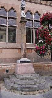
| Market Cross, High Street |
|
|
|
57°28′39″N 4°13′30″W / 57.477478°N 4.224917°W / 57.477478; -4.224917 (Market Cross, High Street) |
Category B |
35261 |
 Upload another image
|
| 36 Huntly Street |
|
|
|
57°28′42″N 4°13′50″W / 57.47833°N 4.230574°W / 57.47833; -4.230574 (36 Huntly Street) |
Category B |
35274 |
|
| 14 And 16 Inglis Street |
|
|
|
57°28′43″N 4°13′23″W / 57.478555°N 4.222964°W / 57.478555; -4.222964 (14 And 16 Inglis Street) |
Category C(S) |
35285 |
|
| 11 Island Bank Road |
|
|
|
57°28′03″N 4°13′36″W / 57.467554°N 4.226682°W / 57.467554; -4.226682 (11 Island Bank Road) |
Category B |
35286 |
|
| 7 Ladies Walk |
|
|
|
57°28′09″N 4°13′39″W / 57.4692°N 4.227616°W / 57.4692; -4.227616 (7 Ladies Walk) |
Category B |
35308 |
|
| Ness Bank Church, Ness Bank and Haugh Road |
|
|
|
57°28′28″N 4°13′34″W / 57.474402°N 4.226098°W / 57.474402; -4.226098 (Ness Bank Church, Ness Bank and Haugh Road) |
Category C(S) |
35319 |
 Upload another image
See more images
|
| Royal Highland Hotel, 18 Academy Street |
|
|
|
57°28′46″N 4°13′24″W / 57.479481°N 4.223437°W / 57.479481; -4.223437 (Royal Highland Hotel, 18 Academy Street) |
Category B |
35129 |
.jpg) Upload another image
See more images
|
| Charleston Place Muirtown House |
|
|
|
57°29′01″N 4°15′11″W / 57.483743°N 4.253143°W / 57.483743; -4.253143 (Charleston Place Muirtown House) |
Category B |
35171 |
|
| 67 Church Street |
|
|
|
57°28′45″N 4°13′39″W / 57.479033°N 4.227414°W / 57.479033; -4.227414 (67 Church Street) |
Category B |
35174 |
|
| 111 Church Street |
|
|
|
57°28′48″N 4°13′42″W / 57.480006°N 4.22829°W / 57.480006; -4.22829 (111 Church Street) |
Category B |
35178 |
|
| Church Street, Greyfriars Free Church |
|
|
|
57°28′49″N 4°13′43″W / 57.480162°N 4.2286°W / 57.480162; -4.2286 (Church Street, Greyfriars Free Church) |
Category B |
35182 |
|
| Clachnaharry Road Dunolly |
|
|
|
57°29′21″N 4°15′25″W / 57.489093°N 4.256926°W / 57.489093; -4.256926 (Clachnaharry Road Dunolly) |
Category B |
35189 |
|
| 26 Culduthel Road |
|
|
|
57°28′12″N 4°13′22″W / 57.469878°N 4.222804°W / 57.469878; -4.222804 (26 Culduthel Road) |
Category B |
35208 |
|
| 28 Abban Street, St Michael And All Angels Episcopal Church Rectory With Boundary Walls |
|
|
|
57°28′54″N 4°14′15″W / 57.481775°N 4.237507°W / 57.481775; -4.237507 (28 Abban Street, St Michael And All Angels Episcopal Church Rectory With Boundary Walls) |
Category B |
35115 |
|
| 20 Ness Bank |
|
|
|
57°28′22″N 4°13′38″W / 57.4728°N 4.227268°W / 57.4728; -4.227268 (20 Ness Bank) |
Category C(S) |
35326 |
|
| 1-13 (Odd Numbers Only) Queensgate And 33 Academy Street |
|
|
|
57°28′46″N 4°13′32″W / 57.479401°N 4.225434°W / 57.479401; -4.225434 (1-13 (Odd Numbers Only) Queensgate And 33 Academy Street) |
Category B |
35343 |
|
| 37 Southside Road |
|
|
|
57°28′17″N 4°13′12″W / 57.471391°N 4.220061°W / 57.471391; -4.220061 (37 Southside Road) |
Category B |
35348 |
|
| 60 Telford Street And Outbuilding And Garden Wall |
|
|
|
57°28′54″N 4°14′34″W / 57.481691°N 4.24274°W / 57.481691; -4.24274 (60 Telford Street And Outbuilding And Garden Wall) |
Category B |
35364 |
|
| 42 Wells Street |
|
|
|
57°28′50″N 4°14′12″W / 57.480432°N 4.236724°W / 57.480432; -4.236724 (42 Wells Street) |
Category C(S) |
35378 |
|
| 38 Wells Street |
|
|
|
57°28′50″N 4°14′12″W / 57.480506°N 4.236578°W / 57.480506; -4.236578 (38 Wells Street) |
Category C(S) |
35380 |
|
| 5 And 7 Young Street |
|
|
|
57°28′36″N 4°13′43″W / 57.476557°N 4.228731°W / 57.476557; -4.228731 (5 And 7 Young Street) |
Category C(S) |
35387 |
|
| 9 And 11 Young Street |
|
|
|
57°28′36″N 4°13′44″W / 57.476537°N 4.228863°W / 57.476537; -4.228863 (9 And 11 Young Street) |
Category C(S) |
35388 |
|
| 10 Culduthel Road, Viewmount |
|
|
|
57°28′24″N 4°13′29″W / 57.47326°N 4.224644°W / 57.47326; -4.224644 (10 Culduthel Road, Viewmount) |
Category B |
35215 |
|
| 15 Douglas Row |
|
|
|
57°28′49″N 4°13′51″W / 57.48034°N 4.230746°W / 57.48034; -4.230746 (15 Douglas Row) |
Category B |
35228 |
|
| 18 Douglas Row |
|
|
|
57°28′49″N 4°13′50″W / 57.480219°N 4.230472°W / 57.480219; -4.230472 (18 Douglas Row) |
Category B |
35231 |
|
| 19 Douglas Row |
|
|
|
57°28′49″N 4°13′49″W / 57.480176°N 4.230369°W / 57.480176; -4.230369 (19 Douglas Row) |
Category B |
35232 |
|
| 11 Drummond Crescent |
|
|
|
57°27′44″N 4°13′37″W / 57.462195°N 4.226873°W / 57.462195; -4.226873 (11 Drummond Crescent) |
Category B |
35239 |
|
| 2 Eastgate |
|
|
|
57°28′41″N 4°13′22″W / 57.478101°N 4.22272°W / 57.478101; -4.22272 (2 Eastgate) |
Category B |
35242 |
|
| Greig Street Footbridge |
|
|
|
57°28′45″N 4°13′48″W / 57.479061°N 4.229884°W / 57.479061; -4.229884 (Greig Street Footbridge) |
Category B |
35248 |
.JPG) Upload another image
See more images
|
| 3 Hill Place |
|
|
|
57°28′40″N 4°13′21″W / 57.47768°N 4.222611°W / 57.47768; -4.222611 (3 Hill Place) |
Category B |
35263 |
|
| 4 Huntly Place |
|
|
|
57°28′54″N 4°14′07″W / 57.481733°N 4.235285°W / 57.481733; -4.235285 (4 Huntly Place) |
Category B |
35265 |
|
| Huntly Street And King Street, Inverness Roman Catholic Junior Secondary School |
|
|
|
57°28′41″N 4°13′48″W / 57.478167°N 4.23013°W / 57.478167; -4.23013 (Huntly Street And King Street, Inverness Roman Catholic Junior Secondary School) |
Category B |
35273 |
|
| 6 And 8 Inglis Street |
|
|
|
57°28′42″N 4°13′22″W / 57.478404°N 4.222872°W / 57.478404; -4.222872 (6 And 8 Inglis Street) |
Category B |
35283 |
|
| 10 And 12 Inglis Street |
|
|
|
57°28′43″N 4°13′23″W / 57.478483°N 4.222926°W / 57.478483; -4.222926 (10 And 12 Inglis Street) |
Category C(S) |
35284 |
|
| 29 Island Bank Road, Carrol |
|
|
|
57°27′43″N 4°13′49″W / 57.461813°N 4.230217°W / 57.461813; -4.230217 (29 Island Bank Road, Carrol) |
Category B |
35293 |
|
| 38 Island Bank Road |
|
|
|
57°27′39″N 4°14′01″W / 57.460745°N 4.233654°W / 57.460745; -4.233654 (38 Island Bank Road) |
Category B |
35298 |
|
| 3 Ladies Walk |
|
|
|
57°28′12″N 4°13′40″W / 57.469864°N 4.227673°W / 57.469864; -4.227673 (3 Ladies Walk) |
Category B |
35304 |
|
| 5 Ladies Walk |
|
|
|
57°28′11″N 4°13′40″W / 57.469594°N 4.227656°W / 57.469594; -4.227656 (5 Ladies Walk) |
Category C(S) |
35306 |
|
| 6 Ladies Walk |
|
|
|
57°28′10″N 4°13′40″W / 57.469379°N 4.22766°W / 57.469379; -4.22766 (6 Ladies Walk) |
Category B |
35307 |
|
| 10 Ardross Street |
|
|
|
57°28′30″N 4°13′49″W / 57.474902°N 4.230331°W / 57.474902; -4.230331 (10 Ardross Street) |
Category B |
35135 |
|
| Town Steeple, 2 Bridge Street And Church Street |
|
|
|
57°28′39″N 4°13′32″W / 57.477538°N 4.225571°W / 57.477538; -4.225571 (Town Steeple, 2 Bridge Street And Church Street) |
Category A |
35153 |
.jpg) Upload another image
See more images
|
| Chapel Street Chapel Yard, Gatepiers And Boundary Wall |
|
|
|
57°28′53″N 4°13′44″W / 57.481307°N 4.228937°W / 57.481307; -4.228937 (Chapel Street Chapel Yard, Gatepiers And Boundary Wall) |
Category C(S) |
35170 |
|
| 19 Church Street |
|
|
|
57°28′40″N 4°13′33″W / 57.47773°N 4.225917°W / 57.47773; -4.225917 (19 Church Street) |
Category B |
35172 |
|
| 7 Culduthel Road |
|
|
|
57°28′25″N 4°13′26″W / 57.47355°N 4.223961°W / 57.47355; -4.223961 (7 Culduthel Road) |
Category B |
35197 |
|
| 19 Culduthel Road |
|
|
|
57°28′15″N 4°13′18″W / 57.470834°N 4.221544°W / 57.470834; -4.221544 (19 Culduthel Road) |
Category C(S) |
35199 |
|
| St Michael and All Angels Episcopal Church, Abban Street and Lochalsh Road |
|
|
|
57°28′55″N 4°14′16″W / 57.481844°N 4.237644°W / 57.481844; -4.237644 (St Michael and All Angels Episcopal Church, Abban Street and Lochalsh Road) |
Category B |
35114 |
.jpg) Upload another image
|
| 118, 120, 122 Academy Street |
|
|
|
57°28′51″N 4°13′41″W / 57.480845°N 4.228091°W / 57.480845; -4.228091 (118, 120, 122 Academy Street) |
Category C(S) |
35121 |
|
| Eden Court Theatre Including Sculpture, Ness Walk |
|
|
|
57°28′23″N 4°13′51″W / 57.473079°N 4.230821°W / 57.473079; -4.230821 (Eden Court Theatre Including Sculpture, Ness Walk) |
Category A |
49959 |
.jpg) Upload another image
See more images
|
| 7-9 (Inclusive) Falcon Square |
|
|
|
57°28′45″N 4°13′23″W / 57.479263°N 4.223041°W / 57.479263; -4.223041 (7-9 (Inclusive) Falcon Square) |
Category C(S) |
35244 |
.jpg) Upload another image
|