List of listed buildings in Helensburgh
This is a list of listed buildings in the parish of Helensburgh in Argyll and Bute, Scotland.
List
| Name | Location | Date Listed | Grid Ref. [note 1] | Geo-coordinates | Notes | HB Number [note 2] | Image |
|---|---|---|---|---|---|---|---|
| 1 Sutherland Crescent Upper, Rhuarden With Conservatory And Gatepiers | 56°00′40″N 4°44′39″W / 56.010993°N 4.744067°W | Category B | 34887 |  | |||
| 5, 5A (Bermuda) And 7 William Street | 56°00′17″N 4°44′29″W / 56.004592°N 4.741319°W | Category B | 34892 | | |||
| 22, 24, 26, 28 King Street East, Alma Place, 13 Charlotte Street, 38 Grant Street | 56°00′14″N 4°43′46″W / 56.003957°N 4.729435°W | Category C(S) | 34804 | | |||
| 25-27 (Odd Nos) King Street West, Strathclyde Regional Council Registry Office | 56°00′18″N 4°44′03″W / 56.00509°N 4.734248°W | Category C(S) | 34806 | | |||
| 51-55 (Odd Nos) King Street West And 53 James Street | 56°00′20″N 4°44′14″W / 56.005544°N 4.73728°W | Category C(S) | 34807 | | |||
| 72, 74, 76 King Street West | 56°00′24″N 4°44′29″W / 56.006634°N 4.741255°W | Category B | 34809 | | |||
| 22 Millig Street | 56°00′44″N 4°44′47″W / 56.01212°N 4.746362°W | Category B | 34815 | | |||
| 19, 19A, 19B Montrose Street East And 26 Havelock Street | 56°00′21″N 4°43′15″W / 56.005901°N 4.720781°W | Category C(S) | 34816 | | |||
| Old Luss Road, Helensburgh Cemetery Including Boundary Walls, Lodge, Gatepiers And Gates | 56°00′07″N 4°42′46″W / 56.002042°N 4.712762°W | Category B | 34824 | | |||
| 150, 152 Princes Street East, Giffnock House With Lodge And Boundary Wall | 56°00′05″N 4°43′17″W / 56.001346°N 4.721472°W | Category B | 34828 | | |||
| 73-79 (Odd Nos) Princes Street West | 56°00′17″N 4°44′24″W / 56.004812°N 4.739891°W | Category C(S) | 34831 | | |||
| 62-66 (Even Nos) Princes Street West | 56°00′17″N 4°44′11″W / 56.004645°N 4.736478°W | Category B | 34835 | | |||
| 150 Princes Street West, Rosebank And 17, 19 Campbell Street | 56°00′21″N 4°44′32″W / 56.005931°N 4.74212°W | Category B | 34837 | | |||
| Rhu Road Lower, Dalmore Lodge With Boundary Walls And_Gatepiers | 56°00′38″N 4°45′39″W / 56.010469°N 4.760701°W | Category B | 34850 | | |||
| 3, 5 Rowallan Street, West And East Gables | 56°00′45″N 4°44′46″W / 56.012522°N 4.746069°W | Category B | 34853 | | |||
| 33-41 (Odd Nos) Sinclair Street | 56°00′13″N 4°44′02″W / 56.003688°N 4.73386°W | Category C(S) | 34855 | | |||
| Sinclair Street, Dhuhill Lodge With Boundary Wall And Gatepiers | 56°00′55″N 4°43′40″W / 56.01516°N 4.727643°W | Category B | 34864 | | |||
| Sinclair Street, Hermitage Park, War Memorial And Walled Garden With Ornamental Gates | 56°00′30″N 4°43′42″W / 56.008261°N 4.728279°W | Category A | 34872 | | |||
| 19 Suffolk Street And 1 Sutherland Crescent Lower | 56°00′34″N 4°44′38″W / 56.00944°N 4.744005°W | Category C(S) | 34879 | | |||
| 150 Clyde Street East, Rockland And Sundial | 55°59′54″N 4°43′05″W / 55.998332°N 4.717971°W | Category A | 34737 | | |||
| 154 Clyde Street East, Rockfort And Folly | 55°59′50″N 4°43′02″W / 55.997271°N 4.717175°W | Category B | 34741 | | |||
| 42-45 (Inclusive Nos) Clyde Street West | 56°00′13″N 4°44′14″W / 56.003673°N 4.737356°W | Category B | 34748 | | |||
| 95,96 Clyde Street West, Flower Bank | 56°00′16″N 4°44′29″W / 56.004309°N 4.741508°W | Category C(S) | 34749 | | |||
| 4 Colquhoun Street Upper, Braeriach With Boundary Wall, Gatepiers And Gates | 56°00′56″N 4°43′45″W / 56.015677°N 4.729059°W | Category B | 34759 | | |||
| 19-25 (Inc Nos) Colquhoun Square And 46-60 (Even Nos)_Prince's Street West | 56°00′17″N 4°44′11″W / 56.004612°N 4.73638°W | Category B | 34765 | | |||
| 4-9 (Inclusive Nos) Craigendoran Avenue | 55°59′52″N 4°42′56″W / 55.997828°N 4.71553°W | Category C(S) | 34768 | | |||
| Dhuhill Drive West, Greycourt | 56°00′59″N 4°43′51″W / 56.01635°N 4.730743°W | Category A | 34771 | | |||
| 1-14 (Inclusive Nos) Glenan Gardens, Argyle Street West | 56°00′24″N 4°44′18″W / 56.00677°N 4.738361°W | Category C(S) | 34783 | | |||
| 22 Glenfinlas Street Upper, Clunie Hill With Boundary Wall And Gatepiers | 56°00′25″N 4°43′16″W / 56.006953°N 4.721176°W | Category B | 34784 | | |||
| 77 James Street, Methilfield | 56°00′27″N 4°44′10″W / 56.00752°N 4.736168°W | Category C(S) | 34787 | | |||
| 32-44 (Even Nos) John Street | 56°00′19″N 4°44′19″W / 56.005144°N 4.738695°W | Category C(S) | 34794 | | |||
| King Street East, Baptist Church | 56°00′18″N 4°43′56″W / 56.004984°N 4.732139°W | Category B | 34802 | | |||
| 13 Abercromby Street East And 50 Charlotte Street, Hapland With Boundary Walls, Gatepiers And Former Coach House | 56°00′38″N 4°43′23″W / 56.010599°N 4.722957°W | Category B | 34697 | | |||
| 18 Abercromby Street West, Summer House | 56°00′44″N 4°44′13″W / 56.012266°N 4.736937°W | Category C(S) | 34700 | | |||
| 165 Clyde Street East Corner Adelaide Street | 56°00′06″N 4°43′24″W / 56.001692°N 4.723308°W | Category C(S) | 34725 | | |||
| 16 Clyde Street East And 7-9 (Odd Nos) Maitland Street | 56°00′09″N 4°43′57″W / 56.002533°N 4.732415°W | Category C(S) | 34728 | | |||
| 104 Clyde Street East | 56°00′03″N 4°43′22″W / 56.000938°N 4.722854°W | Category C(S) | 34732 | | |||
| Clyde Street School With East Lodge, West Lodge (No 38 Clyde Street East) And Boundary Wall, Gates And Railings | 56°00′08″N 4°43′49″W / 56.002232°N 4.730212°W | Category B | 45268 | | |||
| 2 Sutherland Street Upper, Terpersie (Formerly Thurloe) | 56°00′40″N 4°44′40″W / 56.011102°N 4.744428°W | Category B | 34890 | | |||
| King Street West, West King Street Hall (St Columba's Hall) | 56°00′19″N 4°44′01″W / 56.005359°N 4.733497°W | Category C(S) | 34808 | | |||
| 29 Montrose Street East And 4 Adelaide Street Upper | 56°00′19″N 4°43′04″W / 56.005349°N 4.717678°W | Category C(S) | 34817 | | |||
| 4 Munro Drive West, Brantwoode With Boundary Wall, Gatepiers, Garage And Garden Gate | 56°00′47″N 4°43′46″W / 56.012979°N 4.729511°W | Category A | 34822 | | |||
| 1 Princes Street East And 48, 50, 52, 52A Sinclair Street, Municipal Buildings | 56°00′15″N 4°43′59″W / 56.004057°N 4.73302°W | Category B | 34825 | | |||
| 76 Princes Street East, Former Rifle Hall | 56°00′11″N 4°43′46″W / 56.003001°N 4.729561°W | Category B | 34827 | | |||
| 61-65 (Odd Nos) Princes Street West And 22-28 (Even Nos) John Street | 56°00′16″N 4°44′20″W / 56.004463°N 4.739016°W | Category C(S) | 34830 | | |||
| 8, 10, 12 Princes Street West | 56°00′15″N 4°44′02″W / 56.004111°N 4.733826°W | Category B | 34832 | | |||
| 14-28 (Even Nos) Princes Street West | 56°00′15″N 4°44′03″W / 56.004226°N 4.734299°W | Category B | 34833 | | |||
| 6 Queen Street, Haywood And Sundial | 56°00′39″N 4°43′53″W / 56.010949°N 4.731485°W | Category C(S) | 34840 | | |||
| Rhu Road Higher, Dalmore, West Lodge With Boundary Wall And Gatepiers | 56°00′42″N 4°45′41″W / 56.011785°N 4.76134°W | Category B | 34846 | | |||
| 113 Sinclair Street, Moorlands With Conservatory And Gatepiers | 56°00′42″N 4°43′48″W / 56.01172°N 4.729983°W | Category B | 34862 | | |||
| 22-34 (Even Nos) Sinclair Street | 56°00′12″N 4°44′00″W / 56.003388°N 4.733213°W | Category C(S) | 34867 | | |||
| Sinclair Street, Hermitage Park, Bust Of Logie Baird | 56°00′29″N 4°43′51″W / 56.008044°N 4.730751°W | Category C(S) | 34870 | | |||
| 134 Sinclair Street, Albion Lodge | 56°00′56″N 4°43′23″W / 56.015534°N 4.722935°W | Category B | 34877 | | |||
| 23 Suffolk Street, The Grange With Boundary Wall And Gatepiers And 39 Millig Street, The Ingle | 56°00′39″N 4°44′36″W / 56.010937°N 4.74339°W | Category C(S) | 34880 | | |||
| 6 Sutherland Crescent Lower | 56°00′37″N 4°44′46″W / 56.010325°N 4.746218°W | Category C(S) | 34885 | | |||
| 148 Clyde Street East, Cromalt House With Boundary Walls And Gatepiers | 55°59′56″N 4°43′07″W / 55.998872°N 4.718715°W | Category B | 34735 | | |||
| Clyde Street East, Rockland Lodge With Gatepiers, Gates And Boundary Wall | 55°59′56″N 4°43′00″W / 55.998762°N 4.716783°W | Category B | 34738 | | |||
| Colquhoun Square, Bank Of Scotland | 56°00′17″N 4°44′05″W / 56.004836°N 4.734775°W | Category B | 34753 | | |||
| Colquhoun Square, Celtic Cross | 56°00′16″N 4°44′08″W / 56.004423°N 4.73558°W | Category B | 34764 | | |||
| 29 Glasgow Street | 56°00′37″N 4°44′31″W / 56.010151°N 4.741938°W | Category C(S) | 34782 | | |||
| James Street, Former La Scala Cinema | 56°00′14″N 4°44′14″W / 56.003868°N 4.737097°W | Category C(S) | 34789 | | |||
| 46-56 (Even Nos) John Street | 56°00′20″N 4°44′19″W / 56.005418°N 4.738538°W | Category C(S) | 34795 | | |||
| John Street Provost Lamp Standards At No 68 | 56°00′24″N 4°44′17″W / 56.006742°N 4.737974°W | Category B | 34796 | | |||
| 32 Argyle Street West With Gatepiers And Gates | 56°00′30″N 4°44′41″W / 56.008417°N 4.744703°W | Category B | 34707 | | |||
| 44 Charlotte Street | 56°00′30″N 4°43′26″W / 56.008222°N 4.723961°W | Category C(S) | 34719 | | |||
| 121 Clyde Street East | 56°00′07″N 4°43′40″W / 56.00201°N 4.727646°W | Category B | 34721 | | |||
| Princes Street East, Helensburgh Central Station Including Platforms, Canopies, Screen Walls And Gates | 56°00′14″N 4°43′54″W / 56.00379°N 4.73167°W | Category B | 48538 | | |||
| 7 Sutherland Crescent Lower | 56°00′37″N 4°44′48″W / 56.010227°N 4.74658°W | Category C(S) | 34886 | | |||
| 4 Sutherland Street | 56°00′20″N 4°44′49″W / 56.005493°N 4.746854°W | Category C(S) | 34888 | | |||
| 6 Sutherland Street | 56°00′20″N 4°44′48″W / 56.005639°N 4.746784°W | Category C(S) | 34889 | | |||
| 17 William Street | 56°00′19″N 4°44′27″W / 56.005322°N 4.740826°W | Category C(S) | 34893 | | |||
| 25 And 27 William Street | 56°00′20″N 4°44′26″W / 56.005658°N 4.740657°W | Category B | 34894 | | |||
| William Street, St Michael And All Angels' Episcopal Church Rectory | 56°00′17″N 4°44′25″W / 56.004703°N 4.740381°W | Category C(S) | 34897 | | |||
| 108 King Street West, Carisbrooke With Gatepiers, Gates And Conservatory | 56°00′29″N 4°44′44″W / 56.008018°N 4.745685°W | Category B | 34810 | | |||
| 20 Millig Street And 33 Queen Street, Woodend With Conservatory, Boundary And Garden Walls, Gatepiers, Gates, Lamp Standard And Garage | 56°00′44″N 4°44′39″W / 56.012122°N 4.744244°W | Category B | 34814 | | |||
| 146 Sinclair Street, Drum-Millig | 56°00′59″N 4°43′21″W / 56.016255°N 4.72244°W | Category B | 34878 | | |||
| 17, 18 And 19 Clyde Street West | 56°00′12″N 4°44′07″W / 56.003279°N 4.735275°W | Category C(S) | 34745 | | |||
| 36 Clyde Street West | 56°00′13″N 4°44′12″W / 56.003596°N 4.736789°W | Category B | 34747 | | |||
| 41 Colquhoun Street, Galloway Cottage | 56°00′34″N 4°44′01″W / 56.009338°N 4.733634°W | Category B | 34755 | | |||
| John Street, Provost Lamp Standards At No 51, Helensburgh Library | 56°00′27″N 4°44′16″W / 56.007625°N 4.737908°W | Category B | 34793 | | |||
| 70 John Street, Corner Argyle Street | 56°00′26″N 4°44′14″W / 56.00721°N 4.737141°W | Category B | 34797 | | |||
| 19 Abercromby Street East | 56°00′37″N 4°43′05″W / 56.010399°N 4.718161°W | Category B | 34699 | | |||
| 2 Adelaide Street With Gatepiers And Railings | 56°00′04″N 4°43′24″W / 56.001028°N 4.723278°W | Category B | 34701 | | |||
| Ardencaple Castle | 56°00′33″N 4°45′25″W / 56.00914°N 4.757012°W | Category B | 34703 | | |||
| 38 Argyle Street West, Garthland | 56°00′32″N 4°44′47″W / 56.008773°N 4.746509°W | Category C(S) | 34709 | | |||
| 29 And 31 Campbell Street | 56°00′26″N 4°44′31″W / 56.007259°N 4.741813°W | Category C(S) | 34711 | | |||
| 38 And 40 Campbell Street, Burnside | 56°00′26″N 4°44′27″W / 56.0072°N 4.740846°W | Category B | 34712 | | |||
| 50 Campbell Street, Westburn | 56°00′36″N 4°44′20″W / 56.010129°N 4.738888°W | Category B | 34713 | | |||
| 43 Charlotte Street | 56°00′35″N 4°43′28″W / 56.009621°N 4.724508°W | Category B | 34717 | | |||
| 46 Charlotte Street, Arden And 16 Abercromby Street East, Upper Arden | 56°00′34″N 4°43′22″W / 56.009461°N 4.72278°W | Category B | 34720 | | |||
| Clyde Street East, East Bay Esplanade, Public Shelters And Lavatories | 56°00′06″N 4°43′29″W / 56.001544°N 4.724726°W | Category C(S) | 34731 | | |||
| William Street, St Michael And All Angels' Episcopal Church And Church Hall | 56°00′18″N 4°44′25″W / 56.004959°N 4.740158°W | Category A | 34896 | | |||
| 30-34 (Even Nos) Princes Street West | 56°00′15″N 4°44′04″W / 56.004268°N 4.734446°W | Category C(S) | 34834 | | |||
| 25 Queen Street With Boundary Wall | 56°00′42″N 4°44′27″W / 56.011587°N 4.740804°W | Category C(S) | 34839 | | |||
| 10 Queen Street, Westward | 56°00′40″N 4°43′59″W / 56.011248°N 4.733015°W | Category C(S) | 34841 | | |||
| 32 Queen Street, Deanston With Gatepiers | 56°00′44″N 4°44′26″W / 56.01221°N 4.740688°W | Category C(S) | 34844 | | |||
| 101 Sinclair Street, Millfield With Gatepiers | 56°00′28″N 4°43′56″W / 56.007642°N 4.732278°W | Category B | 34858 | | |||
| 109 Sinclair Street, Cawdor Lodge And 111 Sinclair Street, Tower House | 56°00′36″N 4°43′51″W / 56.009956°N 4.730886°W | Category B | 34861 | | |||
| 127 Sinclair Street, Dhuhill And Gatepiers | 56°00′57″N 4°43′37″W / 56.015875°N 4.727003°W | Category B | 34863 | | |||
| 135 Sinclair Street, Ardluss With Boundary Wall, Gatepiers And Gates | 56°00′59″N 4°43′31″W / 56.016423°N 4.725389°W | Category B | 34865 | | |||
| 25 Suffolk Street, Auchenteil With Boundary Walls And Gatepiers | 56°00′43″N 4°44′35″W / 56.011871°N 4.743007°W | Category B | 34881 | | |||
| 122 Clyde Street West And 2 Sutherland Street | 56°00′19″N 4°44′49″W / 56.005302°N 4.746985°W | Category C(S) | 34752 | | |||
| Douglas Drive, Tordarroch With Boundary Wall, Gatepiers And Gates | 56°00′53″N 4°43′42″W / 56.014792°N 4.728419°W | Category B | 34773 | | |||
| 23 Glasgow Street | 56°00′30″N 4°44′34″W / 56.008236°N 4.742765°W | Category C(S) | 34780 | | |||
| Kennedy Drive, Cuilvona | 56°01′01″N 4°43′37″W / 56.016821°N 4.726925°W | Category B | 34800 | | |||
| 4 Albert Street, Moorgate With Boundary Walls | 56°00′29″N 4°43′18″W / 56.008128°N 4.721676°W | Category B | 34702 | | |||
| 10 Argyle Street West And 52, 54 Colquhoun Street, Rosemount With Gatepiers, Gates, Boundary Wall And_Coach-House | 56°00′24″N 4°44′02″W / 56.00668°N 4.733895°W | Category C(S) | 34706 | | |||
| 121 Argyle Street West, The Lodge | 56°00′28″N 4°44′41″W / 56.007832°N 4.744758°W | Category B | 34710 | | |||
| 127 Clyde Street East | 56°00′07″N 4°43′33″W / 56.002003°N 4.725945°W | Category C(S) | 34722 | | |||
| 149-151 (Odd Nos) Clyde Street East And 1-3 (Odd Nos) Glenfinlas Street | 56°00′07″N 4°43′28″W / 56.001983°N 4.724372°W | Category C(S) | 34723 | | |||
| 153 Clyde Street East And 2 Glenfinlas Street | 56°00′06″N 4°43′26″W / 56.001778°N 4.723892°W | Category C(S) | 34724 | | |||
| 108 And 110 Clyde Street East, Rimsdale And Traigh-Na-Mara With Stables, Boundary Walls And Gate | 56°00′03″N 4°43′21″W / 56.000766°N 4.722537°W | Category C(S) | 34733 | | |||
| 37, 39 William Street And 71 King Street West | 56°00′22″N 4°44′26″W / 56.006049°N 4.740476°W | Category B | 34895 | | |||
| 74, 76, 78 King Street East | 56°00′11″N 4°43′26″W / 56.003173°N 4.723814°W | Category C(S) | 34805 | | |||
| 14 Millig Street And 43, 45 Campbell Street With Boundary Wall, Gatepiers And Gates | 56°00′40″N 4°44′23″W / 56.011152°N 4.739779°W | Category B | 34812 | | |||
| 18 Millig Street, Wester Millig, Boundary Walls, Gatepiers And Gates | 56°00′41″N 4°44′29″W / 56.011438°N 4.741452°W | Category B | 34813 | | |||
| 57 Princes East And 17-21 (Odd Nos) Lomond Street | 56°00′11″N 4°43′38″W / 56.002983°N 4.727121°W | Category C(S) | 34826 | | |||
| Princes Street West, Congregational Church | 56°00′16″N 4°44′12″W / 56.004327°N 4.736664°W | Category B | 34829 | | |||
| 186 And 188 Princes Street West, Leewood With Boundary Wall And Gatepiers | 56°00′24″N 4°44′53″W / 56.006755°N 4.747922°W | Category B | 34838 | | |||
| 24 Queen Street With Boundary Wall, Gatepiers And Coach House | 56°00′42″N 4°44′14″W / 56.011684°N 4.737281°W | Category C(S) | 34843 | | |||
| Red Gauntlet Road, Drumfork House | 56°00′01″N 4°42′36″W / 56.000177°N 4.710081°W | Category B | 34845 | | |||
| Rhu Road Lower, Cairndhu House | 56°00′23″N 4°45′12″W / 56.006493°N 4.753198°W | Category A | 34847 | | |||
| Rhu Road Lower, Dalmore House | 56°00′41″N 4°45′34″W / 56.011354°N 4.75932°W | Category A | 34849 | | |||
| 1 Rowallan Street | 56°00′43″N 4°44′45″W / 56.012066°N 4.745957°W | Category B | 34852 | | |||
| 93 Sinclair Street | 56°00′21″N 4°43′58″W / 56.005853°N 4.732714°W | Category C(S) | 34857 | | |||
| 107 Sinclair Street, Thornton Lodge | 56°00′32″N 4°43′53″W / 56.008974°N 4.731394°W | Category B | 34860 | | |||
| Sinclair Street, Old Millig Toll House | 56°00′59″N 4°43′27″W / 56.016362°N 4.724117°W | Category B | 34866 | | |||
| 38-40 Sinclair Street, Former Helensburgh And Gareloch Conservative Club | 56°00′13″N 4°43′59″W / 56.003596°N 4.733148°W | Category A | 34868 | | |||
| Sinclair Street, Hermitage Park, Flywheel And Anvil | 56°00′28″N 4°43′50″W / 56.007708°N 4.730518°W | Category C(S) | 34871 | | |||
| 132 Sinclair Street, Ballytrim And Gatepiers | 56°00′55″N 4°43′29″W / 56.015335°N 4.72459°W | Category C(S) | 34876 | | |||
| 152 Clyde Street East, Tigh-Na-Mara | 55°59′52″N 4°43′03″W / 55.997903°N 4.717444°W | Category B | 34739 | | |||
| Clyde Street East, Rockfort Lodge, Boundary Walls And Gatepiers | 55°59′55″N 4°42′58″W / 55.998501°N 4.715978°W | Category C(S) | 34742 | | |||
| Imperial Hotel, 12 Clyde Street West | 56°00′11″N 4°44′17″W / 56.003173°N 4.738027°W | Category C(S) | 34744 | | |||
| 119 Clyde Street West With Boundary Wall And Gatepiers | 56°00′19″N 4°44′46″W / 56.005153°N 4.745995°W | Category B | 34751 | | |||
| 49 Colquhoun Street, Pynhannot House | 56°00′44″N 4°43′56″W / 56.012086°N 4.732095°W | Category B | 34756 | | |||
| 2 Colquhoun Street Upper, Whincroft With Boundary Wall And Gatepiers | 56°00′50″N 4°43′48″W / 56.013824°N 4.729939°W | Category B | 34758 | | |||
| 8 Colquhoun Street Upper, The Hill House With Outbuildings, Boundary Walls And Gates | 56°01′03″N 4°43′42″W / 56.017381°N 4.728441°W | Category A | 34761 | 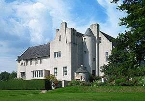 | |||
| Colquhoun Square, The West Kirk (Church Of Scotland) | 56°00′18″N 4°44′09″W / 56.004912°N 4.735823°W | Category B | 34766 | | |||
| Dhuhill Drive West, Letham Hill | 56°00′59″N 4°43′54″W / 56.016526°N 4.731719°W | Category B | 34772 | | |||
| Douglas Drive, Red Towers With Boundary Wall, Gatepiers, Gates And Wellhead | 56°00′53″N 4°43′45″W / 56.014849°N 4.729113°W | Category A | 34774 | | |||
| 46 And 48 George Street, Towerville With Boundary Wall, Gatepiers And Lodge | 56°00′18″N 4°43′23″W / 56.005086°N 4.723066°W | Category B | 34777 | | |||
| 11 Glasgow Street And 115 Princes Street West, Wellcroft | 56°00′20″N 4°44′39″W / 56.0056°N 4.74407°W | Category B | 34779 | | |||
| 25 Glasgow Street | 56°00′31″N 4°44′33″W / 56.008607°N 4.742631°W | Category B | 34781 | | |||
| 27 John Street | 56°00′19″N 4°44′21″W / 56.005396°N 4.739114°W | Category C(S) | 34792 | | |||
| 80 John Street With Boundary Wall And Gatepiers | 56°00′38″N 4°44′11″W / 56.010568°N 4.736496°W | Category B | 34799 | | |||
| 9 East Abercromby Street, Auchenault And 9 East Rossdhu Drive, Dorrator Including Gatepiers And Boundary Walls | 56°00′39″N 4°43′30″W / 56.010955°N 4.725116°W | Category B | 34695 | | |||
| 33 Charlotte Street, The Crossways With Gatepiers | 56°00′29″N 4°43′33″W / 56.008154°N 4.725817°W | Category B | 34715 | | |||
| Victoria Road, The Lindens | 56°00′33″N 4°43′39″W / 56.009205°N 4.727447°W | Category B | 34891 | | |||
| 56 William Street, Upper Ericstane With Screen And Boundary Wall And 7 A Montrose Street West, Lower Ericstane | 56°00′29″N 4°44′20″W / 56.008096°N 4.738969°W | Category C(S) | 34898 | | |||
| 31 Montrose Street East | 56°00′18″N 4°43′02″W / 56.0051°N 4.717131°W | Category B | 34819 | | |||
| 76, 78 Princes Street West And 18, 20 James Street | 56°00′17″N 4°44′13″W / 56.004663°N 4.736913°W | Category B | 34836 | | |||
| Sinclair Street, Church Of St Columba (Church Of Scotland) | 56°00′19″N 4°43′59″W / 56.005267°N 4.733186°W | Category B | 34856 | | |||
| 103 Sinclair Street, Rowanmore With Boundary Wall And Piers | 56°00′29″N 4°43′54″W / 56.008012°N 4.731791°W | Category C(S) | 34859 | | |||
| Sinclair Street, Victoria Halls | 56°00′24″N 4°43′54″W / 56.006659°N 4.731631°W | Category B | 34869 | | |||
| 106 Sinclair Street | 56°00′37″N 4°43′48″W / 56.010166°N 4.729922°W | Category C(S) | 34873 | | |||
| 118 Sinclair Street, Rokneys With Boundary Wall, Gatepiers And Conservatory | 56°00′46″N 4°43′42″W / 56.012717°N 4.728353°W | Category B | 34875 | | |||
| 34 And 36 Suffolk Street, Kintillo House With Garage, Boundary Wall, Gatepiers | 56°00′38″N 4°44′33″W / 56.010622°N 4.742581°W | Category B | 34884 | | |||
| Clyde Street East, Queen's Court (Formerly Queen's Hotel) And Provost's Lamps | 56°00′01″N 4°43′18″W / 56.000302°N 4.721542°W | Category C(S) | 34734 | | |||
| Clyde Street East, Tarandoun Cottage With Boundary Wall, Gatepiers And Gates | 55°59′56″N 4°43′00″W / 55.998755°N 4.716718°W | Category C(S) | 34740 | | |||
| 24 Clyde Street West | 56°00′12″N 4°44′08″W / 56.003333°N 4.73568°W | Category B | 34746 | | |||
| 62 Colquhoun Street, Kildare Lodge With Boundary Wall And Gatepiers | 56°00′30″N 4°43′59″W / 56.008262°N 4.733092°W | Category C(S) | 34757 | | |||
| 3 Craigendoran Avenue | 55°59′53″N 4°42′55″W / 55.998022°N 4.715287°W | Category C(S) | 34767 | | |||
| 4 Glasgow Street, Craigbank | 56°00′18″N 4°44′38″W / 56.004939°N 4.743895°W | Category C(S) | 34778 | | |||
| 23 Henry Bell Street, Redcote | 56°00′16″N 4°42′58″W / 56.004545°N 4.716226°W | Category B | 34786 | | |||
| 17 And 19 (Odd Nos) John Street | 56°00′17″N 4°44′22″W / 56.004796°N 4.739393°W | Category C(S) | 34791 | | |||
| 76 John Street, Glen Kin With Boundary Wall And Gatepiers | 56°00′32″N 4°44′12″W / 56.008812°N 4.736661°W | Category B | 34798 | | |||
| 45 Charlotte Street | 56°00′35″N 4°43′26″W / 56.009848°N 4.723995°W | Category B | 34718 | | |||
| 217 Clyde Street East, Willowbank And Boundary Walls | 56°00′00″N 4°43′06″W / 56.000075°N 4.718383°W | Category C(S) | 34726 | | |||
| 4 Clyde Street East, Tourist Information Centre (Bell Tower Of Former Parish Church | 56°00′10″N 4°44′02″W / 56.002665°N 4.733788°W | Category C(S) | 34727 | | |||
| 60 Clyde Street East | 56°00′07″N 4°43′42″W / 56.002028°N 4.728465°W | Category C(S) | 34729 | | |||
| 20 Queen Street, Ardvuela And Gatepiers | 56°00′43″N 4°44′10″W / 56.011851°N 4.736234°W | Category B | 34842 | | |||
| Rhu Road Lower, Cairndhu Lodge With Boundary Wall And Gatepiers | 56°00′20″N 4°45′09″W / 56.005499°N 4.75263°W | Category B | 34848 | | |||
| Rossdhu Drive West, Longcroft | 56°00′47″N 4°44′10″W / 56.013042°N 4.736029°W | Category A | 34851 | | |||
| 22A Suffolk Street | 56°00′29″N 4°44′38″W / 56.008158°N 4.743834°W | Category C(S) | 34882 | | |||
| Clyde Street East, Cromalt Coach House And Stables | 55°59′55″N 4°43′06″W / 55.9987°N 4.718398°W | Category B | 34736 | | |||
| 105, 106 Clyde Street West | 56°00′17″N 4°44′35″W / 56.004588°N 4.743084°W | Category C(S) | 34750 | | |||
| 19 Havelock Street | 56°00′25″N 4°43′15″W / 56.006861°N 4.720833°W | Category C(S) | 34785 | | |||
| 15 King's Crescent (Formerly Towerville Lodge) | 56°00′16″N 4°43′18″W / 56.004401°N 4.721558°W | Category C(S) | 34801 | | |||
| 47 Charlotte Street , Greenpark | 56°00′39″N 4°43′27″W / 56.010798°N 4.72411°W | Category B | 34696 | | |||
| 9 Argyle Street East | 56°00′21″N 4°43′50″W / 56.00589°N 4.730631°W | Category C(S) | 34704 | | |||
| 5 Argyle Street West | 56°00′21″N 4°43′59″W / 56.00591°N 4.732942°W | Category C(S) | 34705 | | |||
| 36 Argyle Street West, Westways | 56°00′31″N 4°44′45″W / 56.008608°N 4.74584°W | Category C(S) | 34708 | | |||
| Charlotte Street, Park Church (Church Of Scotland) And Church Hall With Boundary Wall And Gatepiers | 56°00′17″N 4°43′42″W / 56.004608°N 4.728455°W | Category B | 34714 | | |||
| 41 Charlotte Street | 56°00′34″N 4°43′26″W / 56.009426°N 4.723965°W | Category B | 34716 | | |||
| 82 And 84 Clyde Street East | 56°00′07″N 4°43′40″W / 56.001936°N 4.727737°W | Category C(S) | 34730 | | |||
| Lomond Street, St Joseph's Rc Church With Gatepiers And Gates | 56°00′15″N 4°43′37″W / 56.004227°N 4.726968°W | Category B | 34811 | | |||
| 1 Montrose Street West, Dalfruin With Boundary Wall And Gatepiers | 56°00′27″N 4°44′11″W / 56.00754°N 4.736459°W | Category B | 34820 | | |||
| 6 Munro Drive East, Easterhill | 56°00′45″N 4°43′35″W / 56.012506°N 4.726525°W | Category B | 34821 | | |||
| 6 Munro Drive West, Strathmoyne With Boundary Wall, Gatepiers And Gates | 56°00′47″N 4°43′49″W / 56.013058°N 4.730415°W | Category B | 34823 | | |||
| 116 Sinclair Street, Former West Highland Railway, Helensburgh Upper, Station Master's House | 56°00′44″N 4°43′43″W / 56.012331°N 4.728743°W | Category C(S) | 34874 | | |||
| 26 Suffolk Street | 56°00′32″N 4°44′37″W / 56.008777°N 4.743493°W | Category B | 34883 | | |||
| Clyde Street West, The Esplanade, Monument To Henry Bell | 56°00′12″N 4°44′16″W / 56.003402°N 4.737818°W | Category B | 34743 | | |||
| 18 Colquhoun Street, Post Office | 56°00′15″N 4°44′10″W / 56.004258°N 4.73613°W | Category B | 34754 | | |||
| 6 Colquhoun Street Upper, Lynton With Boundary Wall, Gatepiers And Gates | 56°00′58″N 4°43′42″W / 56.016175°N 4.728468°W | Category B | 34760 | | |||
| 15 Colquhoun Street Upper, The White House With Garage And Boundary Wall | 56°00′54″N 4°43′50″W / 56.015124°N 4.730496°W | Category A | 34762 | | |||
| 17 Upper Colquhoun Street, Drumadoon (Formerly Morar House) With Gatepiers And Boundary Wall And Garden Pavilion | 56°01′03″N 4°43′46″W / 56.017412°N 4.72947°W | Category A | 34763 | | |||
| Dhuhill House And Conservatory, Dhuhill Drive West | 56°00′58″N 4°43′39″W / 56.016054°N 4.727465°W | Category B | 34769 | | |||
| Dhuhill Drive West, Brincliffe With Boundary Wall And Gatepiers | 56°00′59″N 4°43′49″W / 56.016255°N 4.730143°W | Category B | 34770 | | |||
| 3 Easterhill Road | 56°00′40″N 4°43′12″W / 56.011033°N 4.719971°W | Category B | 34775 | | |||
| 4 Easterhill Road, Dunluce | 56°00′41″N 4°43′12″W / 56.011384°N 4.719947°W | Category B | 34776 | | |||
| 89 James Street And 13 Queen Street, Lomond School | 56°00′37″N 4°44′06″W / 56.010406°N 4.734912°W | Category B | 34788 | | |||
| 10 And 12 James Street, Clydesdale Bank | 56°00′15″N 4°44′14″W / 56.004029°N 4.737125°W | Category B | 34790 | | |||
| 93 King Street East, Victoria Infirmary | 56°00′10″N 4°42′55″W / 56.002743°N 4.715217°W | Category B | 34803 | | |||
| 17 Abercromby Street East | 56°00′37″N 4°43′08″W / 56.010151°N 4.718786°W | Category B | 34698 | |
Key
The scheme for classifying buildings in Scotland is:
- Category A: "buildings of national or international importance, either architectural or historic; or fine, little-altered examples of some particular period, style or building type."[1]
- Category B: "buildings of regional or more than local importance; or major examples of some particular period, style or building type, which may have been altered."[1]
- Category C: "buildings of local importance; lesser examples of any period, style, or building type, as originally constructed or moderately altered; and simple traditional buildings which group well with other listed buildings."[1]
In March 2016 there were 47,288 listed buildings in Scotland. Of these, 8 per cent were Category A, and 50 per cent were Category B, with the rest listed at Category C.[2]
See also
Notes
- ↑ Sometimes known as OSGB36, the grid reference (where provided) is based on the British national grid reference system used by the Ordnance Survey.
• "Guide to National Grid". Ordnance Survey. Retrieved 2007-12-12.
• "Get-a-map". Ordnance Survey. Retrieved 2007-12-17. - ↑ The "HB Number" is a unique number assigned to each listed building by Historic Environment Scotland.
References
- All entries, addresses and coordinates are based on data from Historic Scotland. This data falls under the Open Government Licence
- 1 2 3 "What is Listing?". Historic Environment Scotland. Retrieved 29 May 2018.
- ↑ Scotland's Historic Environment Audit 2016 (PDF). Historic Environment Scotland and the Built Environment Forum Scotland. pp. 15–16. Retrieved 29 May 2018.
This article is issued from
Wikipedia.
The text is licensed under Creative Commons - Attribution - Sharealike.
Additional terms may apply for the media files.