List
| Name |
Location |
Date Listed |
Grid Ref. [note 1] |
Geo-coordinates |
Notes |
HB Number [note 2] |
Image |
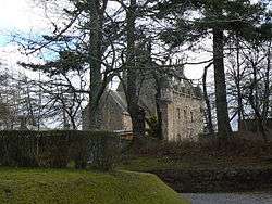
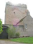
| Holme Rose |
|
|
|
57°30′43″N 3°59′38″W / 57.512072°N 3.993851°W / 57.512072; -3.993851 (Holme Rose) |
Category A |
1812 |

|
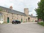
| Cantray Home Farm |
|
|
|
57°30′26″N 4°00′19″W / 57.507302°N 4.005143°W / 57.507302; -4.005143 (Cantray Home Farm) |
Category B |
1708 |
 Upload another image
|
| 2, 3, 4, 5, 6 Clephanton Village |
|
|
|
57°31′47″N 3°58′37″W / 57.529787°N 3.976929°W / 57.529787; -3.976929 (2, 3, 4, 5, 6 Clephanton Village) |
Category B |
1837 |
|
| Dalcross Castle And Garden Wall |
|
|
|
57°30′30″N 4°02′25″W / 57.508266°N 4.040252°W / 57.508266; -4.040252 (Dalcross Castle And Garden Wall) |
Category A |
1713 |
 Upload another image
|
| Culloden Battlefield, Old Leanach Farmhouse |
|
|
|
57°28′40″N 4°05′41″W / 57.477769°N 4.094612°W / 57.477769; -4.094612 (Culloden Battlefield, Old Leanach Farmhouse) |
Category B |
1712 |
 Upload another image
|
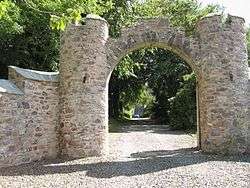
| Dalcross Castle, Entrance Arch And Gate Lodge |
|
|
|
57°30′32″N 4°02′30″W / 57.509026°N 4.041613°W / 57.509026; -4.041613 (Dalcross Castle, Entrance Arch And Gate Lodge) |
Category C(S) |
1714 |
 Upload another image
|
| Croy Parish Church Of Scotland, Watch-House And Burial Ground |
|
|
|
57°31′24″N 4°00′39″W / 57.523211°N 4.010959°W / 57.523211; -4.010959 (Croy Parish Church Of Scotland, Watch-House And Burial Ground) |
Category B |
1710 |
|
| Holme Rose Bridge Over River Nairn |
|
|
|
57°30′49″N 3°58′49″W / 57.513707°N 3.98015°W / 57.513707; -3.98015 (Holme Rose Bridge Over River Nairn) |
Category B |
1840 |
|
| Milton Of Kilravock Former Kilravock Mill |
|
|
|
57°31′58″N 3°56′35″W / 57.532641°N 3.94294°W / 57.532641; -3.94294 (Milton Of Kilravock Former Kilravock Mill) |
Category B |
1842 |
 Upload another image
|
| White Bridge By Clephanton Over River Nairn |
|
|
|
57°31′37″N 3°57′54″W / 57.526835°N 3.965112°W / 57.526835; -3.965112 (White Bridge By Clephanton Over River Nairn) |
Category A |
1843 |
|
| Cantray Mill |
|
|
|
57°30′25″N 4°00′08″W / 57.506826°N 4.002295°W / 57.506826; -4.002295 (Cantray Mill) |
Category B |
1836 |
|
| 7, 8, Clephanton Village |
|
|
|
57°31′46″N 3°58′37″W / 57.52958°N 3.976935°W / 57.52958; -3.976935 (7, 8, Clephanton Village) |
Category B |
1838 |
|
| 9 Clephanton Village |
|
|
|
57°31′46″N 3°58′37″W / 57.52947°N 3.977063°W / 57.52947; -3.977063 (9 Clephanton Village) |
Category B |
1839 |
|
| Kilravock Castle, Dovecote And Garden Walls |
|
|
|
57°31′08″N 3°58′54″W / 57.518833°N 3.98158°W / 57.518833; -3.98158 (Kilravock Castle, Dovecote And Garden Walls) |
Category A |
1841 |
|
| Holme Rose Gate Lodge And Gate Piers |
|
|
|
57°30′31″N 4°00′11″W / 57.508494°N 4.003055°W / 57.508494; -4.003055 (Holme Rose Gate Lodge And Gate Piers) |
Category B |
1814 |
|
| Croy Church Of Scotland Parish Manse |
|
|
|
57°31′29″N 4°00′41″W / 57.524742°N 4.011277°W / 57.524742; -4.011277 (Croy Church Of Scotland Parish Manse) |
Category B |
1711 |
|
| Holme Rose Walled Garden |
|
|
|
57°30′38″N 3°59′35″W / 57.510429°N 3.993194°W / 57.510429; -3.993194 (Holme Rose Walled Garden) |
Category C(S) |
1813 |
|
| Balfreish |
|
|
|
57°29′53″N 4°00′26″W / 57.498157°N 4.007294°W / 57.498157; -4.007294 (Balfreish) |
Category C(S) |
1834 |
|
| Cantray Bridge Over River Nairn |
|
|
|
57°30′24″N 4°00′16″W / 57.506793°N 4.004347°W / 57.506793; -4.004347 (Cantray Bridge Over River Nairn) |
Category B |
1835 |
 Upload another image
|
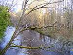
| Clava, Nairn Viaduct Over The Nairn River, Otherwise Known As Culloden Moor Viaduct |
|
|
|
57°28′41″N 4°03′46″W / 57.478098°N 4.062705°W / 57.478098; -4.062705 (Clava, Nairn Viaduct Over The Nairn River, Otherwise Known As Culloden Moor Viaduct) |
Category A |
1709 |
|
| Daltullich Mains House |
|
|
|
57°27′00″N 4°06′21″W / 57.449891°N 4.105818°W / 57.449891; -4.105818 (Daltullich Mains House) |
Category B |
1715 |
|
Key
The scheme for classifying buildings in Scotland is:
- Category A: "buildings of national or international importance, either architectural or historic; or fine, little-altered examples of some particular period, style or building type."[1]
- Category B: "buildings of regional or more than local importance; or major examples of some particular period, style or building type, which may have been altered."[1]
- Category C: "buildings of local importance; lesser examples of any period, style, or building type, as originally constructed or moderately altered; and simple traditional buildings which group well with other listed buildings."[1]
In March 2016 there were 47,288 listed buildings in Scotland. Of these, 8 per cent were Category A, and 50 per cent were Category B, with the rest listed at Category C.[2]