List of listed buildings in Bo'ness And Carriden, Falkirk
This is a list of listed buildings in the parish of Bo'ness And Carriden in Falkirk, Scotland.
List
| Name | Location | Date Listed | Grid Ref. [note 1] | Geo-coordinates | Notes | HB Number [note 2] | Image |
|---|---|---|---|---|---|---|---|
| Blackness House | 56°00′12″N 3°31′35″W / 56.003311°N 3.526252°W | Category B | 4130 |  | |||
| Grangemouth, Inveravon Tower | 55°59′58″N 3°40′46″W / 55.999514°N 3.679338°W | Category C(S) | 4146 | | |||
| Railway Viaduct Over River Avon Near Birch-Hill | 55°59′20″N 3°39′24″W / 55.988787°N 3.656574°W | Category B | 4132 | | |||
| Grangemouth Road, Avon Bridge | 56°00′23″N 3°40′43″W / 56.006316°N 3.678703°W | Category C(S) | 4145 | | |||
| Blackness Lowvalley House | 56°00′13″N 3°31′24″W / 56.003653°N 3.523267°W | Category C(S) | 4131 | | |||
| Blackness Castle | 56°00′21″N 3°30′59″W / 56.005877°N 3.516313°W | Category A | 230 | 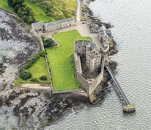 | |||
| Airngath Farm | 55°59′43″N 3°36′09″W / 55.995245°N 3.602431°W | Category B | 4133 | | |||
| Muirhouses, 18 And 19 Carriden Brae Including Boundary Walls | 56°00′28″N 3°34′30″W / 56.007857°N 3.574917°W | Category B | 22370 | | |||
| Muirhouses, 20 Carriden Brae And Carriden Cottage Including Boundary Walls And Ancillary Structures | 56°00′27″N 3°34′28″W / 56.007547°N 3.574551°W | Category C(S) | 22371 | | |||
| 25, 27 And 29 North Street | 56°01′03″N 3°36′33″W / 56.017577°N 3.609195°W | Category C(S) | 22376 | | |||
| 37- 43 (Odd Nos) North Street And 7- 9 Scotland's Close | 56°01′04″N 3°36′31″W / 56.017782°N 3.608675°W | Category B | 22378 | | |||
| 13 South Street, Former Tolbooth | 56°01′02″N 3°36′32″W / 56.017259°N 3.608813°W | Category B | 22394 | | |||
| Union Street, Harbour | 56°01′12″N 3°36′25″W / 56.019998°N 3.606825°W | Category C(S) | 22399 | | |||
| 14 - 20 (Even Nos) Union Street And 3 - 11 (Odd Nos) Register Street, Former Custom House | 56°01′07″N 3°36′22″W / 56.018542°N 3.606203°W | Category B | 22400 | | |||
| Bridgeness Lane Bridgeness Cottage Including Boundary Walls | 56°00′57″N 3°34′56″W / 56.015733°N 3.582232°W | Category B | 22335 | | |||
| Bridgeness, Kinningars Park Dovecot Including Wall And Capped Pit Shaft | 56°00′52″N 3°34′59″W / 56.014347°N 3.583122°W | Category B | 22336 | | |||
| 15A And 15B Cadzow Crescent, Tidings Hill Including Gatepiers And Boundary Walls And Ancillary Structures | 56°00′50″N 3°36′26″W / 56.013963°N 3.607297°W | Category B | 22338 | | |||
| Market Street,K6 Telephone Kiosk | 56°01′04″N 3°36′28″W / 56.017758°N 3.607727°W | Category B | 22366 | | |||
| Muirhouses, Carriden Brae, Old Schoolhouse And The Old School House Including Boundary Walls And Ancillary Structures | 56°00′28″N 3°34′32″W / 56.007796°N 3.575444°W | Category B | 22369 | | |||
| 1 - 11 (Odd Nos) Seaview Place | 56°01′00″N 3°36′36″W / 56.016712°N 3.610058°W | Category C(S) | 49709 | | |||
| 15 And 17 South Street | 56°01′02″N 3°36′31″W / 56.017261°N 3.608621°W | Category C(S) | 49711 | | |||
| 24 - 32 (Even Nos) South Street | 56°01′01″N 3°36′31″W / 56.017063°N 3.608645°W | Category C(S) | 49718 | | |||
| 191-199 (Odd Nos) Corbiehall Including Boundary Walls | 56°00′52″N 3°36′57″W / 56.014488°N 3.615917°W | Category B | 50167 | | |||
| Dean Road Cemetery Including Gatepiers, Railings And Boundary Walls | 56°00′45″N 3°36′55″W / 56.012583°N 3.615212°W | Category C(S) | 50485 | | |||
| Muirhouses, 7 Hope Cottages And 8 Hope Cottages, Cleveland Including Boundary Walls | 56°00′27″N 3°34′31″W / 56.007431°N 3.575156°W | Category B | 22372 | | |||
| Muirhouses, 3 And 4 Hope Cottages | 56°00′25″N 3°34′32″W / 56.006968°N 3.575554°W | Category C(S) | 22374 | | |||
| North Street, The Hippodrome | 56°01′03″N 3°36′30″W / 56.017589°N 3.608265°W | Category A | 22380 | | |||
| Scotland's Close, Bo'ness Public Library, Former Old West Pier Tavern | 56°01′05″N 3°36′32″W / 56.01814°N 3.60877°W | Category B | 22388 | | |||
| Stewart Avenue, Town Hall And Former Carnegie Library Including Boundary Walls And Gatepiers | 56°00′57″N 3°36′29″W / 56.015768°N 3.608013°W | Category B | 22397 | | |||
| 15 North Street And 27 Waggon Road | 56°01′03″N 3°36′34″W / 56.017366°N 3.60954°W | Category B | 22403 | | |||
| Church Wynd, Graveyards Including Boundary Walls | 56°00′57″N 3°36′38″W / 56.015779°N 3.610645°W | Category A | 22350 | | |||
| Kinneil, 6-8 (Inclusive Nos) Duchess Anne Cottages | 56°00′26″N 3°37′56″W / 56.007176°N 3.632099°W | Category B | 22362 | | |||
| 26 East Pier Street,Post Office Including Boundary Walls And Gatepiers | 56°01′06″N 3°36′25″W / 56.018354°N 3.606837°W | Category C(S) | 49702 | | |||
| 8 And 10 Main Street,Ye Olde Carriers Quarters | 56°01′03″N 3°36′19″W / 56.017385°N 3.605353°W | Category C(S) | 49703 | | |||
| 35 - 41 (Odd Nos) South Street | 56°01′03″N 3°36′26″W / 56.017367°N 3.607358°W | Category C(S) | 49715 | | |||
| 50 And 52 South Street | 56°01′02″N 3°36′28″W / 56.017147°N 3.607702°W | Category C(S) | 49720 | | |||
| Links Road, Ballantine Bo'ness Iron Company Limited, Links Road And Stark's Brae Including Boundary Walls | 56°00′58″N 3°35′54″W / 56.016165°N 3.598276°W | Category B | 50202 | | |||
| 12A, 14A, 16A And Nos 16-24 (Even Nos) Craigfoot Terrace Including Boundary Walls | 56°00′59″N 3°35′21″W / 56.016436°N 3.589127°W | Category C(S) | 50483 | | |||
| 109 And 111 Dean Road And 43, 45 And 47 Linlithgow Road, Seaforth Including Boundary Walls | 56°00′40″N 3°36′38″W / 56.01108°N 3.610593°W | Category C(S) | 50484 | | |||
| Kinneil, Kinneil House, Bridge | 56°00′30″N 3°37′41″W / 56.008424°N 3.628078°W | Category C(S) | 50491 | | |||
| 58 - 62 (Even Nos) Union Street, Former Foundry Offices | 56°01′05″N 3°36′10″W / 56.018109°N 3.602864°W | Category B | 22401 | | |||
| 49 North Street,Dymock's Buildings With Scotland's Close Warehouse And Service Court | 56°01′05″N 3°36′30″W / 56.01809°N 3.608463°W | Category A | 22379 | | |||
| 1 And 3 South Street With 12 North Street | 56°01′02″N 3°36′34″W / 56.017152°N 3.609418°W | Category C(S) | 22390 | | |||
| 9 South Street | 56°01′02″N 3°36′33″W / 56.01721°N 3.6091°W | Category C(S) | 22392 | | |||
| Carriden Old Church And Graveyard Including Gatepiers And Boundary Walls | 56°00′50″N 3°34′32″W / 56.013878°N 3.575515°W | Category B | 22347 | | |||
| Glebe Park Bandstand (Off Stewart Avenue) | 56°00′55″N 3°36′30″W / 56.015278°N 3.60841°W | Category B | 22353 | | |||
| Kinneil, Kinneil House Including Gatepiers To West And East And Boundary Walls | 56°00′26″N 3°38′03″W / 56.007103°N 3.634213°W | Category A | 22358 | | |||
| 2 - 6 (Even Nos) Main Street,The Bo'ness Tavern | 56°01′03″N 3°36′19″W / 56.017375°N 3.605401°W | Category C(S) | 22364 | | |||
| Muirhouses, Acre Road, Grangewells | 56°00′30″N 3°34′37″W / 56.008469°N 3.576915°W | Category B | 22367 | | |||
| 43 - 51 (Odd Nos) Corbiehall Including Boundary Walls | 56°00′55″N 3°36′43″W / 56.015376°N 3.611927°W | Category B | 49701 | | |||
| 31 And 33 South Street | 56°01′02″N 3°36′28″W / 56.017352°N 3.607871°W | Category C(S) | 49714 | | |||
| 47 And 49 South Street | 56°01′03″N 3°36′25″W / 56.017398°N 3.607054°W | Category C(S) | 49717 | | |||
| Carriden Brae, Grange Lodge Including Gate Piers And Boundary Walls | 56°00′37″N 3°34′33″W / 56.010279°N 3.57593°W | Category C(S) | 50480 | | |||
| Grange Loan, Grange School Including Gatepiers And Boundary Walls | 56°00′51″N 3°35′24″W / 56.014179°N 3.589868°W | Category C(S) | 50487 | | |||
| Harbour Road, Plaque Including Boundary Wall | 56°00′59″N 3°35′01″W / 56.016444°N 3.583544°W | Category C(S) | 50489 | | |||
| 31, 33 And 35 North Street Including Boundary Walls | 56°01′04″N 3°36′33″W / 56.017659°N 3.609151°W | Category C(S) | 22377 | | |||
| Bo'ness Station, Former Haymarket Train Shed, Former Wormit Station Building, Signal Box, Footbridge, Goods Office, Goods Yard, Water Tank And Lamp Standards | 56°01′05″N 3°36′01″W / 56.017961°N 3.600388°W | Category A | 22337 | | |||
| Carriden, Carriden House Including Boundary Walls | 56°00′38″N 3°33′55″W / 56.010485°N 3.565352°W | Category A | 22339 | | |||
| Carriden, Carriden House, The Steading Including Ancillary Structures | 56°00′35″N 3°34′02″W / 56.009786°N 3.567344°W | Category C(S) | 22341 | | |||
| Grahamsdyke Avenue, Caer Edin Including Gatepiers And Boundary Walls | 56°00′50″N 3°35′36″W / 56.013892°N 3.59337°W | Category B | 22354 | | |||
| Bridgeness, Harbour Road, The Tower Gardens, Bridgeness Tower | 56°00′57″N 3°35′05″W / 56.015954°N 3.584631°W | Category B | 22357 | | |||
| 50 And 52 North Street | 56°01′04″N 3°36′29″W / 56.017798°N 3.608114°W | Category C(S) | 49705 | | |||
| 44 South Street, Turf Tavern | 56°01′02″N 3°36′28″W / 56.017127°N 3.607909°W | Category C(S) | 49719 | | |||
| Stewart Avenue, War Memorial | 56°00′54″N 3°36′39″W / 56.015068°N 3.610759°W | Category C(S) | 49724 | | |||
| Carriden, Carriden House Ice House | 56°00′39″N 3°33′45″W / 56.010756°N 3.562459°W | Category C(S) | 50481 | | |||
| 12-16 (Even Nos) Corbiehall Including Boundary Walls, Gates And Railings And Ancillary Structures | 56°00′58″N 3°36′42″W / 56.016233°N 3.611658°W | Category C(S) | 50482 | | |||
| Kinneil, Kinneil House, Walled Garden | 56°00′24″N 3°37′58″W / 56.006665°N 3.632655°W | Category C(S) | 50492 | | |||
| 42 - 54 (Even Nos), North Street, Anchor Tavern | 56°01′04″N 3°36′30″W / 56.017779°N 3.608209°W | Category C(S) | 22381 | | |||
| 74 North Street | 56°01′03″N 3°36′26″W / 56.017512°N 3.607332°W | Category B | 22382 | | |||
| Providence Brae, Former St Mary's Roman Catholic Church Including Boundary Wall And Gatepier | 56°00′58″N 3°36′31″W / 56.016175°N 3.608544°W | Category B | 22386 | | |||
| 39 - 49 (Odd Nos) Scotland's Close | 56°01′05″N 3°36′32″W / 56.017921°N 3.609001°W | Category B | 22389 | | |||
| 5 And 7 South Street With 14 North Street | 56°01′02″N 3°36′33″W / 56.017217°N 3.609229°W | Category C(S) | 22391 | | |||
| 68 And 70 South Street | 56°01′02″N 3°36′24″W / 56.017213°N 3.60679°W | Category C(S) | 22396 | | |||
| Carriden, Carriden House, West Lodge | 56°00′35″N 3°34′31″W / 56.009605°N 3.575197°W | Category C(S) | 22345 | | |||
| Carriden Brae, Carriden Parish Church (Church Of Scotland) Including Gate Piers And Boundary Walls | 56°00′52″N 3°34′30″W / 56.014378°N 3.575134°W | Category B | 22346 | | |||
| 101 And 103 Corbiehall Including Boundary Wall | 56°00′54″N 3°36′48″W / 56.015097°N 3.613279°W | Category C(S) | 22351 | | |||
| Grange Terrace, St Andrews Parish Church Including Hall And Boundary Walls | 56°00′53″N 3°35′42″W / 56.014697°N 3.595039°W | Category B | 22355 | | |||
| Kinneil, 2 - 4 (Inclusive Nos) Duchess Anne Cottages Including Boundary Walls | 56°00′29″N 3°37′56″W / 56.008044°N 3.632345°W | Category B | 22361 | | |||
| 19 Church Wynd | 56°00′58″N 3°36′36″W / 56.016154°N 3.610115°W | Category C(S) | 49700 | | |||
| North Street, Clock And Lamp Standard | 56°01′05″N 3°36′28″W / 56.018044°N 3.607835°W | Category C(S) | 49706 | | |||
| 15 Seaview Place, Former Bank And Burgh Chambers Including Boundary Wall And Gatepier | 56°01′00″N 3°36′37″W / 56.016557°N 3.610212°W | Category C(S) | 49710 | | |||
| 43 And 45 South Street | 56°01′03″N 3°36′26″W / 56.017405°N 3.607199°W | Category C(S) | 49716 | | |||
| 62 South Street | 56°01′02″N 3°36′25″W / 56.017165°N 3.607061°W | Category C(S) | 49721 | | |||
| 37 Stewart Avenue, Former Liberal Hall | 56°00′58″N 3°36′31″W / 56.016103°N 3.608508°W | Category C(S) | 49723 | | |||
| 17 Cadzow Crescent, Former Nurses' Home Including Gatepiers And Boundary Walls | 56°00′49″N 3°36′23″W / 56.013607°N 3.606287°W | Category C(S) | 50479 | | |||
| Kinneil, 5 Duchess Anne Cottages, Kinneil Museum Including Boundary Wall | 56°00′28″N 3°37′57″W / 56.007844°N 3.632545°W | Category B | 50490 | | |||
| Muirhouses, 1 And 2 Hope Cottages | 56°00′25″N 3°34′35″W / 56.007057°N 3.576328°W | Category C(S) | 22373 | | |||
| 1 Market Street | 56°01′03″N 3°36′27″W / 56.017519°N 3.607428°W | Category C(S) | 22383 | | |||
| Panbrae Road, Old Kirk (Church Of Scotland) Including Hall And Boundary Walls | 56°00′49″N 3°36′57″W / 56.013538°N 3.615733°W | Category B | 22384 | | |||
| Stewart Avenue, Masonic Lodge Including Boundary Walls And Gatepiers | 56°00′58″N 3°36′18″W / 56.016247°N 3.605097°W | Category B | 22398 | | |||
| Erngath Road, The Knowe Including Gatepiers And Boundary Walls | 56°00′53″N 3°36′06″W / 56.014682°N 3.601696°W | Category B | 22352 | | |||
| Muirhouses Acre Road The Library House Including Boundary Walls And Ancillary Structures | 56°00′28″N 3°34′33″W / 56.007746°N 3.575827°W | Category B | 22368 | | |||
| 37 Scotland's Close | 56°01′04″N 3°36′32″W / 56.017795°N 3.608996°W | Category C(S) | 49708 | | |||
| Bridgeness Road, Old Grange Schoolhouse, Including Gatepiers And Boundary Walls | 56°00′54″N 3°34′42″W / 56.015018°N 3.578433°W | Category C(S) | 50478 | | |||
| 73 Grahamsdyke Road Including Gatepiers And Boundary Walls | 56°00′48″N 3°35′25″W / 56.013277°N 3.590184°W | Category B | 50486 | | |||
| 26 Grange Terrace, Roman House Including Gatepiers And Boundary Walls And Ancillary Structure | 56°00′53″N 3°35′54″W / 56.014853°N 3.598238°W | Category B | 50488 | | |||
| Muirhouses, 5 And 6 Hope Cottages Including Boundary Walls | 56°00′25″N 3°34′31″W / 56.006937°N 3.575152°W | Category C(S) | 22375 | | |||
| 11 South Street | 56°01′02″N 3°36′32″W / 56.017248°N 3.608925°W | Category C(S) | 22393 | | |||
| 29 - 43 (Odd Nos) Waggon Road And 9 North Street, The Granary | 56°01′02″N 3°36′35″W / 56.017311°N 3.60965°W | Category B | 22404 | | |||
| Carriden, Carriden House Walled Garden And Gardener's House | 56°00′35″N 3°34′14″W / 56.009808°N 3.570601°W | Category B | 22342 | | |||
| 57 North Street | 56°01′05″N 3°36′29″W / 56.018103°N 3.608126°W | Category C(S) | 49704 | | |||
| North Street And Market Street, Jubilee Fountain | 56°01′04″N 3°36′27″W / 56.017742°N 3.607566°W | Category C(S) | 49707 | | |||
| 23 - 29 (Odd Nos) South Street, Anderson Building | 56°01′02″N 3°36′29″W / 56.017322°N 3.608094°W | Category C(S) | 49712 | | |||
| 64, 64A And 66 South Street | 56°01′02″N 3°36′25″W / 56.017203°N 3.606886°W | Category C(S) | 49722 | | |||
| 54 - 60 (Even Nos) South Street | 56°01′02″N 3°36′27″W / 56.017142°N 3.607429°W | Category B | 22395 | | |||
| Braehead, Craigmailen United Free Church Including Gatepiers And Boundary Wall | 56°00′52″N 3°36′28″W / 56.014549°N 3.607834°W | Category B | 22334 | | |||
| Market Street, Clydesdale Bank | 56°01′04″N 3°36′28″W / 56.017695°N 3.607756°W | Category B | 22365 | |
Key
The scheme for classifying buildings in Scotland is:
- Category A: "buildings of national or international importance, either architectural or historic; or fine, little-altered examples of some particular period, style or building type."[1]
- Category B: "buildings of regional or more than local importance; or major examples of some particular period, style or building type, which may have been altered."[1]
- Category C: "buildings of local importance; lesser examples of any period, style, or building type, as originally constructed or moderately altered; and simple traditional buildings which group well with other listed buildings."[1]
In March 2016 there were 47,288 listed buildings in Scotland. Of these, 8 per cent were Category A, and 50 per cent were Category B, with the rest listed at Category C.[2]
See also
Notes
- ↑ Sometimes known as OSGB36, the grid reference (where provided) is based on the British national grid reference system used by the Ordnance Survey.
• "Guide to National Grid". Ordnance Survey. Retrieved 2007-12-12.
• "Get-a-map". Ordnance Survey. Retrieved 2007-12-17. - ↑ The "HB Number" is a unique number assigned to each listed building by Historic Environment Scotland.
References
- All entries, addresses and coordinates are based on data from Historic Scotland. This data falls under the Open Government Licence
- 1 2 3 "What is Listing?". Historic Environment Scotland. Retrieved 29 May 2018.
- ↑ Scotland's Historic Environment Audit 2016 (PDF). Historic Environment Scotland and the Built Environment Forum Scotland. pp. 15–16. Retrieved 29 May 2018.
This article is issued from
Wikipedia.
The text is licensed under Creative Commons - Attribution - Sharealike.
Additional terms may apply for the media files.