List of listed buildings in Arrochar, Argyll
This is a list of listed buildings in the parish of Arrochar in Argyll and Bute, Scotland.
List
| Name | Location | Date Listed | Grid Ref. [note 1] | Geo-coordinates | Notes | HB Number [note 2] | Image |
|---|---|---|---|---|---|---|---|
| Arrochar, Glenloin House With Ice House And Gatepiers | 56°12′26″N 4°44′32″W / 56.20734°N 4.742297°W | Category C(S) | 43182 |  | |||
| Arrochar, Mansefield | 56°11′36″N 4°45′02″W / 56.193443°N 4.750429°W | Category B | 43184 | | |||
| Ballyhennan, The Black Sheep Arts And Crafts Centre | 56°12′11″N 4°43′13″W / 56.203136°N 4.720211°W | Category C(S) | 43185 | 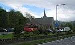 | |||
| Arrochar Parish Church | 56°11′41″N 4°44′53″W / 56.194835°N 4.748062°W | Category B | 826 | 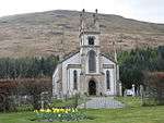 | |||
| Arrochar, Claymore Hotel (Former Inverioch Or Arrochar House (Including Gatepiers) | 56°11′50″N 4°44′50″W / 56.197327°N 4.747128°W | Category B | 829 | | |||
| Stuckgowan House | 56°11′21″N 4°42′03″W / 56.189154°N 4.700781°W | Category A | 861 | | |||
| Arrochar, Invereoch | 56°11′38″N 4°45′01″W / 56.193843°N 4.7502°W | Category C(S) | 43183 | | |||
| Sloy Awe Hydro Electric Scheme, Sloy Power Station Including Boundary Walls, Gates And Gatepiers | 56°15′40″N 4°45′52″W / 56.261234°N 4.76445°W | Category A | 43188 | 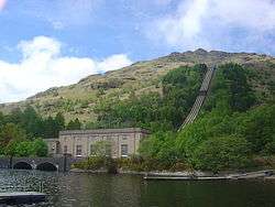 | |||
| Arrochar, Old Parish Church | 56°11′41″N 4°44′53″W / 56.194681°N 4.748083°W | Category B | 825 | | |||
| Arrochar, Church Road, The Steadings | 56°11′46″N 4°44′41″W / 56.196112°N 4.7448°W | Category C(S) | 830 | | |||
| Tarbet Hotel | 56°12′13″N 4°42′40″W / 56.203731°N 4.711143°W | Category B | 832 | 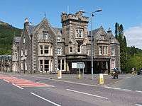 | |||
| Creag-An-Arnain Railway Viaduct | 56°15′30″N 4°42′34″W / 56.258198°N 4.709553°W | Category B | 864 | | |||
| Ardlui Railway Station Building with Subway and Gates | 56°18′07″N 4°43′19″W / 56.302059°N 4.72189°W | Category C(S) | 43177 | 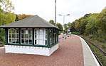 | |||
| Inveruglas Barn | 56°14′51″N 4°42′50″W / 56.247616°N 4.713794°W | Category C(S) | 43186 | | |||
| Arrochar and Tarbet Station With Control Box, Subway And Gates | 56°12′11″N 4°43′26″W / 56.203085°N 4.723755°W | Category B | 865 | 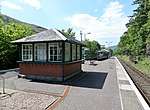 | |||
| Ardmay House With Gatepiers | 56°11′11″N 4°46′08″W / 56.186515°N 4.76884°W | Category C(S) | 43179 | 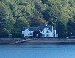 | |||
| Inveruglas Steading | 56°14′49″N 4°42′50″W / 56.246905°N 4.71384°W | Category C(S) | 43187 | | |||
| Ballyhennan, Burial Ground, Monuments And Boundary Wall | 56°12′12″N 4°43′14″W / 56.203379°N 4.7206°W | Category C(S) | 827 |  | |||
| Edendarroch House | 56°12′01″N 4°42′26″W / 56.200214°N 4.707138°W | Category C(S) | 831 | | |||
| Stuckgowan Cottage | 56°11′19″N 4°41′55″W / 56.188655°N 4.698538°W | Category C(S) | 863 | | |||
| Ardlui, Former Station Master's House | 56°18′09″N 4°43′18″W / 56.302362°N 4.721589°W | Category C(S) | 43178 | | |||
| Sloy Power Station, Bungalow | 56°15′00″N 4°42′43″W / 56.249904°N 4.711921°W | Category C(S) | 43190 | | |||
| Tarbet, Lochview And Post Office | 56°12′16″N 4°42′44″W / 56.204326°N 4.712281°W | Category C(S) | 820 | | |||
| Stuckgowan House, North Lodge, Walled Garden And Kennels/Stables | 56°11′24″N 4°42′00″W / 56.189907°N 4.700044°W | Category B | 862 | | |||
| Sloy Awe Hydro Electric Scheme, Loch Sloy Dam | 56°15′42″N 4°45′48″W / 56.261671°N 4.7634°W | Category B | 51712 | 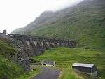 | |||
| Arrochar, Fascadail | 56°11′43″N 4°44′50″W / 56.195394°N 4.747183°W | Category C(S) | 43181 | | |||
| Arrochar, Lynwood Hotel (Formerly Oaklands Hotel) | 56°11′35″N 4°45′06″W / 56.193056°N 4.751643°W | Category C(S) | 828 | | |||
| Ardlui, K6 Telephone Box | 56°18′07″N 4°43′15″W / 56.301885°N 4.720811°W | Category B | 866 | 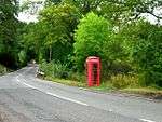 | |||
| Arrochar, Cobbler Cottage | 56°11′49″N 4°44′49″W / 56.196964°N 4.746908°W | Category B | 43180 | | |||
| Sloy Power Station, Bridge | 56°14′59″N 4°42′42″W / 56.2497°N 4.711794°W | Category C(S) | 43189 | |
Key
The scheme for classifying buildings in Scotland is:
- Category A: "buildings of national or international importance, either architectural or historic; or fine, little-altered examples of some particular period, style or building type."[1]
- Category B: "buildings of regional or more than local importance; or major examples of some particular period, style or building type, which may have been altered."[1]
- Category C: "buildings of local importance; lesser examples of any period, style, or building type, as originally constructed or moderately altered; and simple traditional buildings which group well with other listed buildings."[1]
In March 2016 there were 47,288 listed buildings in Scotland. Of these, 8 per cent were Category A, and 50 per cent were Category B, with the rest listed at Category C.[2]
See also
Notes
- ↑ Sometimes known as OSGB36, the grid reference (where provided) is based on the British national grid reference system used by the Ordnance Survey.
• "Guide to National Grid". Ordnance Survey. Retrieved 2007-12-12.
• "Get-a-map". Ordnance Survey. Retrieved 2007-12-17. - ↑ The "HB Number" is a unique number assigned to each listed building by Historic Environment Scotland.
References
- All entries, addresses and coordinates are based on data from Historic Scotland. This data falls under the Open Government Licence
- 1 2 3 "What is Listing?". Historic Environment Scotland. Retrieved 29 May 2018.
- ↑ Scotland's Historic Environment Audit 2016 (PDF). Historic Environment Scotland and the Built Environment Forum Scotland. pp. 15–16. Retrieved 29 May 2018.
This article is issued from
Wikipedia.
The text is licensed under Creative Commons - Attribution - Sharealike.
Additional terms may apply for the media files.