| Name |
Location |
Date Listed |
Grid Ref. [note 1] |
Geo-coordinates |
Notes |
HB Number [note 2] |
Image |
| Loch Creran, Mill Farm |
|
|
|
56°30′47″N 5°21′28″W / 56.512938°N 5.35787°W / 56.512938; -5.35787 (Loch Creran, Mill Farm) |
Category B |
6435 |

|
| Ichrachan Township Near Taynuilt, Cottage Near Roadside At West End Of Township |
|
|
|
56°25′36″N 5°13′38″W / 56.426715°N 5.227241°W / 56.426715; -5.227241 (Ichrachan Township Near Taynuilt, Cottage Near Roadside At West End Of Township) |
Category B |
6368 |
|
| Ichrachan Township Near Taynuilt, Ichrachan Cottages |
|
|
|
56°25′38″N 5°13′35″W / 56.42727°N 5.226314°W / 56.42727; -5.226314 (Ichrachan Township Near Taynuilt, Ichrachan Cottages) |
Category C(S) |
6370 |
|
| Inverawe House |
|
|
|
56°26′06″N 5°12′37″W / 56.434906°N 5.210217°W / 56.434906; -5.210217 (Inverawe House) |
Category B |
4699 |
|
| St. Conan's Church Of Scotland, Lochawe |
|
|
|
56°23′43″N 5°03′15″W / 56.39527°N 5.05416°W / 56.39527; -5.05416 (St. Conan's Church Of Scotland, Lochawe) |
Category A |
4700 |
|
| Ardchattan Priory Church |
|
|
|
56°27′45″N 5°17′42″W / 56.462529°N 5.294941°W / 56.462529; -5.294941 (Ardchattan Priory Church) |
Category B |
4714 |
|
| Ben Cruachan Hydro Electric Scheme, Turbine Hall |
|
|
|
56°23′37″N 5°06′45″W / 56.393612°N 5.112456°W / 56.393612; -5.112456 (Ben Cruachan Hydro Electric Scheme, Turbine Hall) |
Category A |
51688 |
|
| Ardchattan Manse |
|
|
|
56°27′40″N 5°17′14″W / 56.461132°N 5.287301°W / 56.461132; -5.287301 (Ardchattan Manse) |
Category C(S) |
5116 |
|
| Barcaldine Bridge, Abhain Leithil |
|
|
|
56°31′37″N 5°18′32″W / 56.526973°N 5.308932°W / 56.526973; -5.308932 (Barcaldine Bridge, Abhain Leithil) |
Category C(S) |
4720 |
|
| Nelson Monument Taynuilt |
|
|
|
56°25′47″N 5°14′12″W / 56.429696°N 5.236676°W / 56.429696; -5.236676 (Nelson Monument Taynuilt) |
Category B |
4704 |
|
| Taynuilt Inn Taynuilt |
|
|
|
56°25′44″N 5°14′23″W / 56.428954°N 5.239614°W / 56.428954; -5.239614 (Taynuilt Inn Taynuilt) |
Category B |
107 |
|
| Druimavuic, Roadside Cairns Flanking A828 |
|
|
|
56°33′16″N 5°14′40″W / 56.554496°N 5.244354°W / 56.554496; -5.244354 (Druimavuic, Roadside Cairns Flanking A828) |
Category C(S) |
48528 |
|
| Eriska House Isle Of Eriska |
|
|
|
56°31′58″N 5°24′45″W / 56.532707°N 5.412609°W / 56.532707; -5.412609 (Eriska House Isle Of Eriska) |
Category C(S) |
4698 |
|
| Achnacloich House (Stonefield) |
|
|
|
56°27′14″N 5°19′10″W / 56.453779°N 5.319313°W / 56.453779; -5.319313 (Achnacloich House (Stonefield)) |
Category B |
4706 |
|
| Ardchattan House |
|
|
|
56°27′45″N 5°17′42″W / 56.462529°N 5.294941°W / 56.462529; -5.294941 (Ardchattan House) |
Category B |
4715 |
|
| Lochnell House Ardmucknish Bay |
|
|
|
56°29′43″N 5°26′10″W / 56.495263°N 5.436059°W / 56.495263; -5.436059 (Lochnell House Ardmucknish Bay) |
Category A |
4716 |
|
| Lonan Hotel (Barguilean House) |
|
|
|
56°24′58″N 5°14′46″W / 56.416159°N 5.246246°W / 56.416159; -5.246246 (Lonan Hotel (Barguilean House)) |
Category B |
4705 |
|
| Shian House South Shian Loch Creran |
|
|
|
56°31′30″N 5°24′06″W / 56.5251°N 5.40153°W / 56.5251; -5.40153 (Shian House South Shian Loch Creran) |
Category C(S) |
4718 |
|
| Lochnell House, Ardmucknish Bay, Barn (Bull House) |
|
|
|
56°29′46″N 5°25′58″W / 56.496°N 5.43281°W / 56.496; -5.43281 (Lochnell House, Ardmucknish Bay, Barn (Bull House)) |
Category C(S) |
44719 |
|
| Muckairn Manse Taynuilt |
|
|
|
56°25′42″N 5°14′09″W / 56.42822°N 5.235707°W / 56.42822; -5.235707 (Muckairn Manse Taynuilt) |
Category B |
4703 |
|
| Lochnell House, Ardmucknish Bay, Steading |
|
|
|
56°29′43″N 5°26′02″W / 56.49538°N 5.433794°W / 56.49538; -5.433794 (Lochnell House, Ardmucknish Bay, Steading) |
Category B |
44720 |
|
| Ichrachan Township Near Taynuilt, Starling Cottage |
|
|
|
56°25′38″N 5°13′35″W / 56.427298°N 5.226252°W / 56.427298; -5.226252 (Ichrachan Township Near Taynuilt, Starling Cottage) |
Category C(S) |
6369 |
|
| Glenure House |
|
|
|
56°35′02″N 5°11′10″W / 56.583835°N 5.186108°W / 56.583835; -5.186108 (Glenure House) |
Category B |
4697 |
|
| Ardchattan Kirk Achnaba |
|
|
|
56°28′15″N 5°20′17″W / 56.470763°N 5.338013°W / 56.470763; -5.338013 (Ardchattan Kirk Achnaba) |
Category B |
4712 |
|
| Falls Of Cruachan Railway Viaduct |
|
|
|
56°23′40″N 5°06′51″W / 56.394502°N 5.114263°W / 56.394502; -5.114263 (Falls Of Cruachan Railway Viaduct) |
Category A |
50811 |
|
| Ben Cruachan Hydro Electric Scheme, Cruachan Dam |
|
|
|
56°24′23″N 5°06′47″W / 56.406468°N 5.113117°W / 56.406468; -5.113117 (Ben Cruachan Hydro Electric Scheme, Cruachan Dam) |
Category B |
51687 |
|
| Druimavuic Ballieveolon House |
|
|
|
56°33′11″N 5°14′34″W / 56.553152°N 5.242806°W / 56.553152; -5.242806 (Druimavuic Ballieveolon House) |
Category B |
4721 |
|
| Loch Awe House |
|
|
|
56°24′07″N 5°02′33″W / 56.401832°N 5.042463°W / 56.401832; -5.042463 (Loch Awe House) |
Category C(S) |
4701 |
|
| Muckairn Kirk Taynuilt |
|
|
|
56°25′44″N 5°14′12″W / 56.428912°N 5.236772°W / 56.428912; -5.236772 (Muckairn Kirk Taynuilt) |
Category B |
4702 |
|
| Old Ardchattan Kirk (Kilmodan) Baile Mhaodan |
|
|
|
56°27′59″N 5°17′43″W / 56.466396°N 5.295227°W / 56.466396; -5.295227 (Old Ardchattan Kirk (Kilmodan) Baile Mhaodan) |
Category C(S) |
4713 |
|
| Lochnell Observatory (St. Margaret's Tower) Lochnell Policies |
|
|
|
56°29′22″N 5°26′29″W / 56.48935°N 5.441488°W / 56.48935; -5.441488 (Lochnell Observatory (St. Margaret's Tower) Lochnell Policies) |
Category A |
4717 |
|
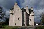
| Barcaldine Castle |
|
|
|
56°30′38″N 5°24′06″W / 56.510578°N 5.401643°W / 56.510578; -5.401643 (Barcaldine Castle) |
Category A |
4719 |
 Upload another image
|