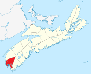
| Name |
Address |
Coordinates |
IDF |
IDP |
IDM |
 |
Image |
|---|
| African Bethel Cemetery |
Greenville Road, Pleasant Lake and Greenville, NS |
43°51′13″N 66°01′05″W / 43.8537°N 66.018°W / 43.8537; -66.018 (African Bethel Cemetery) |
|
|
9064 |
|
 |
| Argyle Historic Church and Cemetery |
19 Argyle Head Road, Argyle, NS |
43°47′47″N 65°51′26″W / 43.7963°N 65.8572°W / 43.7963; -65.8572 (Argyle Historic Church and Cemetery) |
|
7696 |
15108 |
|
|
| Argyle Township Court House Archives |
8168 Highway 3, Tusket, NS |
43°51′16″N 65°58′27″W / 43.8544°N 65.9742°W / 43.8544; -65.9742 (Argyle Township Court House Archives) |
|
|
15163 |
|
|
| Argyle Township Court House and Jail National Historic Site of Canada |
8168 Highway 3, Tusket, NS |
43°34′25″N 65°46′04″W / 43.5735°N 65.7678°W / 43.5735; -65.7678 (Argyle Township Court House and Jail National Historic Site of Canada) |
11952 |
5753 |
15162 |
|
 |
| At the Sign of the Whale |
543 No 1 Hwy, Dayton, NS |
43°52′38″N 66°05′50″W / 43.8771°N 66.0971°W / 43.8771; -66.0971 (At the Sign of the Whale) |
|
3500 |
5203 |
|
|
| J. W. Bingay / Dr. Morton House |
39 Cliff Street, Yarmouth, NS |
43°50′03″N 66°07′06″W / 43.8343°N 66.1183°W / 43.8343; -66.1183 (J. W. Bingay / Dr. Morton House) |
|
|
6959 |
|
|
| Thomas V. B. Bingay House |
22 Forest Street, Yarmouth, NS |
43°50′00″N 66°07′07″W / 43.8334°N 66.1186°W / 43.8334; -66.1186 (Thomas V. B. Bingay House) |
|
|
4590 |
|
|
| Burgess Blackadar House |
24 Prescott Street, Yarmouth, NS |
43°50′36″N 66°06′51″W / 43.8433°N 66.1143°W / 43.8433; -66.1143 (Burgess Blackadar House) |
|
|
6403 |
|
|
| Brenton Methodist Church |
473 Brenton Road, Brenton, NS |
43°57′52″N 66°03′07″W / 43.9644°N 66.052°W / 43.9644; -66.052 (Brenton Methodist Church) |
|
|
9065 |
|
|
| John Brown House |
4 Market Street, Yarmouth, NS |
43°51′03″N 66°06′58″W / 43.8507°N 66.1162°W / 43.8507; -66.1162 (John Brown House) |
|
|
6404 |
|
|
| Stayley Brown House |
12 Vancouver Street, Yarmouth, NS |
43°51′05″N 66°07′00″W / 43.8515°N 66.1168°W / 43.8515; -66.1168 (Stayley Brown House) |
|
|
4919 |
|
|
| Calvinist Baptist Cemetery |
Highway 1, Port Maitland, NS |
43°59′39″N 66°08′46″W / 43.9941°N 66.146°W / 43.9941; -66.146 (Calvinist Baptist Cemetery) |
|
|
9269 |
|
|
| Augustus Cann Estate |
31 Carleton Street, Yarmouth, NS |
43°50′11″N 66°06′55″W / 43.8363°N 66.1154°W / 43.8363; -66.1154 (Augustus Cann Estate) |
|
7670 |
|
|
|
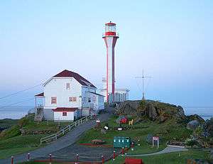
| Cape Forchu Lightstation |
1856 No. 304 Highway, Cape Forchu, NS |
43°47′38″N 66°09′19″W / 43.794°N 66.1554°W / 43.794; -66.1554 (Cape Forchu Lightstation) |
|
6543 |
5205 |
|
 |
| Capt. Charles Carty House |
62 Prospect Street, Dayton, NS |
43°51′27″N 66°06′21″W / 43.8575°N 66.1059°W / 43.8575; -66.1059 (Capt. Charles Carty House) |
|
|
5161 |
|
|
| Central Chebogue United Baptist Church |
796 Chebogue Road, Central Chebogue, NS |
43°47′25″N 66°05′20″W / 43.7903°N 66.089°W / 43.7903; -66.089 (Central Chebogue United Baptist Church) |
|
|
9210 |
|
|
| Chebogue Cemetery |
Town Point Road, Rockville, NS |
43°45′13″N 66°06′00″W / 43.7537°N 66.0999°W / 43.7537; -66.0999 (Chebogue Cemetery) |
|
|
9097 |
|
|
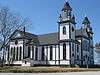
| Chebogue Meeting House |
7 Town Point Road, Rockville, NS |
43°46′43″N 66°06′05″W / 43.7787°N 66.1014°W / 43.7787; -66.1014 (Chebogue Meeting House) |
|
|
5170 |
|
|
| Churchill Mansion |
44 Old Post Road, Darlings Lake, NS |
43°57′32″N 66°08′03″W / 43.9588°N 66.1341°W / 43.9588; -66.1341 (Churchill Mansion) |
|
|
5213 |
|
|
| Zaccheus Churchill House |
47 Old Post Road, Darlings Lake, NS |
43°57′28″N 66°08′13″W / 43.9578°N 66.137°W / 43.9578; -66.137 (Zaccheus Churchill House) |
|
|
9273 |
|
|
| George W. Clements House |
58 Prince Street, Yarmouth, NS |
43°49′55″N 66°07′07″W / 43.8319°N 66.1187°W / 43.8319; -66.1187 (George W. Clements House) |
|
|
6922 |
|
|
| Collins Heritage Conservation District |
Collins and nearby streets, Yarmouth, NS |
43°50′10″N 66°06′57″W / 43.8362°N 66.1158°W / 43.8362; -66.1158 (Collins Heritage Conservation District) |
|
|
4228 |
|
|
| Ebenezer Corning, Jr. House |
405 Pleasant Street, Yarmouth, NS |
43°51′23″N 66°06′04″W / 43.8563°N 66.1011°W / 43.8563; -66.1011 (Ebenezer Corning, Jr. House) |
|
6650 |
4955 |
|
|
| Nehemiah D. Crocker House |
1123 Highway 334, Plymouth, NS |
43°48′00″N 66°00′43″W / 43.8°N 66.0119°W / 43.8; -66.0119 (Nehemiah D. Crocker House) |
|
|
15317 |
|
|
| Samuel Crowell House |
109 Brunswick Street, Yarmouth, NS |
43°50′55″N 66°06′39″W / 43.8485°N 66.1109°W / 43.8485; -66.1109 (Samuel Crowell House) |
|
3288 |
|
|
|
| Durkee Memorial Library |
4048 No. 340 Highway, Carleton, NS |
44°00′27″N 65°55′38″W / 44.0076°N 65.9273°W / 44.0076; -65.9273 (Durkee Memorial Library) |
|
|
5212 |
|
|
| East Kemptville Free Baptist Church |
6 Minor's Road, East Kemptville, NS |
44°05′16″N 65°45′56″W / 44.0878°N 65.7656°W / 44.0878; -65.7656 (East Kemptville Free Baptist Church) |
|
|
15413 |
|
|
| Edmund Ellis House |
3114 No. 1 Highway, Port Maitland, NS |
43°58′41″N 66°08′45″W / 43.978°N 66.1457°W / 43.978; -66.1457 (Edmund Ellis House) |
|
|
5200 |
|
|
| Eldridge House |
26 Chester Street, Yarmouth, NS |
43°50′29″N 66°07′04″W / 43.8413°N 66.1177°W / 43.8413; -66.1177 (Eldridge House) |
|
|
6945 |
|
|
| Founders Cemetery |
Beaver River Road, Beaver River, NS |
44°00′00″N 66°08′43″W / 44°N 66.1454°W / 44; -66.1454 (Founders Cemetery) |
|
|
9081 |
|
|
| Free Will Baptist Cemetery |
Highway 1, Beaver River, NS |
43°59′36″N 66°09′04″W / 43.9932°N 66.151°W / 43.9932; -66.151 (Free Will Baptist Cemetery) |
|
|
9095 |
|
|
| Frost Park |
410 Main Street, Yarmouth, NS |
43°50′20″N 66°07′12″W / 43.8388°N 66.1199°W / 43.8388; -66.1199 (Frost Park) |
|
|
6721 |
|
|
| Fuller House |
20 Collins Street, Yarmouth, NS |
43°50′12″N 66°06′59″W / 43.8368°N 66.1164°W / 43.8368; -66.1164 (Fuller House) |
|
|
6520 |
|
|
| Lindsay Gardner House |
27 Carleton Street, Yarmouth, NS |
43°50′09″N 66°06′57″W / 43.8358°N 66.1158°W / 43.8358; -66.1158 (Lindsay Gardner House) |
|
|
6946 |
|
|
| Gavelton Meeting House |
566 Lake Vaughan Road, Gavelton, NS |
43°53′50″N 65°56′57″W / 43.8972°N 65.9492°W / 43.8972; -65.9492 (Gavelton Meeting House) |
|
|
15209 |
|
|
| Golden Horse Fountain |
Intersection of Main and Vancouver Streets, Yarmouth, NS |
43°51′05″N 66°06′52″W / 43.8513°N 66.1145°W / 43.8513; -66.1145 (Golden Horse Fountain) |
|
|
6792 |
|
|
| Greenville African Baptist Church |
726 Greenville Road, Greenville, NS |
43°51′43″N 66°02′56″W / 43.8619°N 66.0489°W / 43.8619; -66.0489 (Greenville African Baptist Church) |
|
|
5198 |
|
|
| Greenville Church Cemetery |
726 Greenville Road, Greenville, NS |
43°51′39″N 66°02′50″W / 43.8607°N 66.0473°W / 43.8607; -66.0473 (Greenville Church Cemetery) |
|
6524 |
9290 |
|
|
| Guest House |
12 Parade Street, Yarmouth, NS |
43°50′17″N 66°07′04″W / 43.838°N 66.1179°W / 43.838; -66.1179 (Guest House) |
|
3094 |
4826 |
|
|
| Dr. John Harris House |
56 Beaver River Road, Beaver River, NS |
44°00′22″N 66°08′42″W / 44.0061°N 66.1449°W / 44.0061; -66.1449 (Dr. John Harris House) |
|
|
9316 |
|
|
| Job Hatfield House |
57 William Street, Yarmouth, NS |
43°49′55″N 66°07′02″W / 43.8319°N 66.1171°W / 43.8319; -66.1171 (Job Hatfield House) |
|
|
4504 |
|
 |
| Peter Lent Hatfield House |
8007 No. 3 Highway, Tusket, NS |
43°50′59″N 65°58′17″W / 43.8497°N 65.9715°W / 43.8497; -65.9715 (Peter Lent Hatfield House) |
|
7088 |
15142 |
|
|
| Holy Trinity Anglican Church |
63 William Street, Yarmouth, NS |
43°49′57″N 66°07′03″W / 43.8326°N 66.1175°W / 43.8326; -66.1175 (Holy Trinity Anglican Church) |
|
|
7047 |
|
|
| Holy Trinity Anglican Parish Hall |
61 William Street, Yarmouth, NS |
43°49′57″N 66°07′03″W / 43.8325°N 66.1175°W / 43.8325; -66.1175 (Holy Trinity Anglican Parish Hall) |
|
|
7004 |
|
|
| Holy Trinity Rectory |
65 William Street, Yarmouth, NS |
43°49′58″N 66°07′03″W / 43.8328°N 66.1174°W / 43.8328; -66.1174 (Holy Trinity Rectory) |
|
|
7117 |
|
|
| Alexander Hood House |
14 Collins Street, Yarmouth, NS |
43°50′13″N 66°07′04″W / 43.837°N 66.1177°W / 43.837; -66.1177 (Alexander Hood House) |
|
|
6272 |
|
|
| James Jenkins, Jr. House |
503 Main Street, Yarmouth, NS |
43°50′34″N 66°07′05″W / 43.8429°N 66.118°W / 43.8429; -66.118 (James Jenkins, Jr. House) |
|
|
4896 |
|
|
| Capt. Charles P. Kinney House |
34 Porter Street, Yarmouth, NS |
43°50′23″N 66°06′55″W / 43.8396°N 66.1154°W / 43.8396; -66.1154 (Capt. Charles P. Kinney House) |
|
|
4906 |
|
|
| Lake George United Baptist Church |
2092 Lake George Road; RR 1, Lake George, NS |
44°00′34″N 66°03′59″W / 44.0095°N 66.0665°W / 44.0095; -66.0665 (Lake George United Baptist Church) |
|
|
9083 |
|
|
| J. Murray Lawson House |
64 William Street, Yarmouth, NS |
43°49′58″N 66°07′04″W / 43.8329°N 66.1178°W / 43.8329; -66.1178 (J. Murray Lawson House) |
|
3410 |
4918 |
|
|
| Abraham Lent House |
61 Horatio Wood Road, Tusket, NS |
43°50′53″N 65°58′42″W / 43.8481°N 65.9783°W / 43.8481; -65.9783 (Abraham Lent House) |
|
3078 |
15103 |
|
|
| Lewis Fountain |
Argyle and Main Streets, Yarmouth, NS |
43°49′40″N 66°07′17″W / 43.8278°N 66.1213°W / 43.8278; -66.1213 (Lewis Fountain) |
|
|
6663 |
|
|
| Lighthouse |
, Argyle, NS |
43°23′42″N 66°00′49″W / 43.395°N 66.0135°W / 43.395; -66.0135 (Lighthouse) |
4763 |
|
|
|
|
| Lovitt House |
10 Parade Street, Yarmouth, NS |
43°50′16″N 66°07′06″W / 43.8379°N 66.1182°W / 43.8379; -66.1182 (Lovitt House) |
|
3545 |
4578 |
|
|
| Andrew Lovitt House |
90 Main Shore Road, Milton Highlands, NS |
43°51′19″N 66°07′31″W / 43.8554°N 66.1253°W / 43.8554; -66.1253 (Andrew Lovitt House) |
|
|
5207 |
|
|
| Sen. John Lovitt Barn |
10 Parade Street, Yarmouth, NS |
43°50′16″N 66°07′06″W / 43.8378°N 66.1182°W / 43.8378; -66.1182 (Sen. John Lovitt Barn) |
|
|
6271 |
|
|
| William L. Lovitt House |
33 Vancouver Street, Yarmouth, NS |
43°51′09″N 66°07′10″W / 43.8524°N 66.1194°W / 43.8524; -66.1194 (William L. Lovitt House) |
|
|
6224 |
|
|
| MacKinnon-Cann House |
27 Willow Street, Yarmouth, NS |
43°50′11″N 66°07′02″W / 43.8363°N 66.1172°W / 43.8363; -66.1172 (MacKinnon-Cann House) |
|
5462 |
4920 |
|
|
| Charles Moody House |
25 Willow Street, Yarmouth, NS |
43°50′10″N 66°07′02″W / 43.8361°N 66.1172°W / 43.8361; -66.1172 (Charles Moody House) |
|
|
6522 |
|
|
| Rev. John & Sarah Moody House |
17 Forest Street, Yarmouth, NS |
43°49′58″N 66°07′09″W / 43.8328°N 66.1193°W / 43.8328; -66.1193 (Rev. John & Sarah Moody House) |
|
|
6307 |
|
|
| Byron R. Murphy House |
2775 Highway 3, Pubnico, NS |
43°47′47″N 65°51′24″W / 43.7964°N 65.8568°W / 43.7964; -65.8568 (Byron R. Murphy House) |
|
|
15225 |
|
|
| Murray Manor |
225 Main Street, Yarmouth, NS |
43°49′58″N 66°07′11″W / 43.8328°N 66.1197°W / 43.8328; -66.1197 (Murray Manor) |
|
|
4958 |
|
|
| Ensign Nickerson House |
46 Alma Street, Yarmouth, NS |
43°50′08″N 66°06′51″W / 43.8355°N 66.1143°W / 43.8355; -66.1143 (Ensign Nickerson House) |
|
|
7247 |
|
|
| Old Yarmouth Academy |
113 Main Street, Yarmouth, NS |
43°49′42″N 66°07′15″W / 43.8283°N 66.1207°W / 43.8283; -66.1207 (Old Yarmouth Academy) |
|
6527 |
4953 |
|
|
| Port Maitland Cattle Pound |
No. 1 Highway, Port Maitland, NS |
43°58′07″N 66°08′36″W / 43.9687°N 66.1432°W / 43.9687; -66.1432 (Port Maitland Cattle Pound) |
|
|
5160 |
|
|
| Benjamin B. Porter House |
546 Cedar Lake Road, Port Maitland, NS |
44°01′30″N 66°06′12″W / 44.0251°N 66.1032°W / 44.0251; -66.1032 (Benjamin B. Porter House) |
|
|
5210 |
|
|
| George & Elizabeth Porter House |
21 Clements Street, Yarmouth, NS |
43°50′09″N 66°06′50″W / 43.8359°N 66.114°W / 43.8359; -66.114 (George & Elizabeth Porter House) |
|
|
6314 |
|
|
| Knowles Porter House |
9994 No. 3 Highway, Arcadia, NS |
43°49′33″N 66°03′22″W / 43.8258°N 66.0562°W / 43.8258; -66.0562 (Knowles Porter House) |
|
|
9085 |
|
|
| Raynardton Free Baptist Church |
1486 Hamilton Road, Raynardton, NS |
43°55′35″N 65°57′03″W / 43.9263°N 65.9509°W / 43.9263; -65.9509 (Raynardton Free Baptist Church) |
|
|
9317 |
|
|
| William H. Redding House |
625 No. 1 Highway, Hebron, NS |
43°52′48″N 66°05′41″W / 43.8801°N 66.0946°W / 43.8801; -66.0946 (William H. Redding House) |
|
|
5209 |
|
|
| Charles Richards House |
17 Collins Street, Yarmouth, NS |
43°50′11″N 66°06′59″W / 43.8364°N 66.1163°W / 43.8364; -66.1163 (Charles Richards House) |
|
5413 |
|
|
|
| William Ricker House |
10 Rickers Hill Rd., Robert's Island, NS |
43°47′15″N 65°53′03″W / 43.7875°N 65.8842°W / 43.7875; -65.8842 (William Ricker House) |
|
|
15213 |
|
|
| Rockville United Baptist Church |
1379 Chebogue Road, Rockville, NS |
43°46′30″N 66°06′50″W / 43.775°N 66.1139°W / 43.775; -66.1139 (Rockville United Baptist Church) |
|
|
9058 |
|
|
| Sainte Anne's Catholic Church |
7309 Highway 3, Ste. Anne du Ruisseau, NS |
43°50′14″N 65°56′06″W / 43.8372°N 65.935°W / 43.8372; -65.935 (Sainte Anne's Catholic Church) |
|
|
15222 |
|
 |
| St. Stephen's Anglican Church |
8340 No. 3 Highway, Tusket, NS |
43°51′44″N 65°58′37″W / 43.8623°N 65.9769°W / 43.8623; -65.9769 (St. Stephen's Anglican Church) |
|
7262 |
15104 |
|
|
| Capt. Ebenezer Scott House |
37 Alma Street, Yarmouth, NS |
43°50′09″N 66°06′58″W / 43.8357°N 66.1161°W / 43.8357; -66.1161 (Capt. Ebenezer Scott House) |
|
|
8190 |
|
|
| Ellery Scott House |
7 Main Street, Yarmouth, NS |
43°49′14″N 66°07′18″W / 43.8205°N 66.1218°W / 43.8205; -66.1218 (Ellery Scott House) |
|
|
6518 |
|
|
| Alfred Shaw House |
18 Forest Street, Yarmouth, NS |
43°50′00″N 66°07′08″W / 43.8333°N 66.119°W / 43.8333; -66.119 (Alfred Shaw House) |
|
|
4917 |
|
|
| Joseph Sleeth House |
39 Alma Street, Yarmouth, NS |
43°50′08″N 66°06′55″W / 43.8355°N 66.1154°W / 43.8355; -66.1154 (Joseph Sleeth House) |
|
|
6544 |
|
|
| Sluice Point School and Community Centre |
6 L'Anse des Bourques, Sluice Point, NS |
43°47′13″N 65°57′56″W / 43.7869°N 65.9656°W / 43.7869; -65.9656 (Sluice Point School and Community Centre) |
|
|
15210 |
|
|
| South Canaan Free Baptist Church |
638 Wilson Road, South Canaan, NS |
43°55′02″N 65°51′52″W / 43.9171°N 65.8645°W / 43.9171; -65.8645 (South Canaan Free Baptist Church) |
|
|
9213 |
|
|
| Jacob Sweeny House |
44 Huntington Street, Yarmouth, NS |
43°50′54″N 66°06′36″W / 43.8482°N 66.11°W / 43.8482; -66.11 (Jacob Sweeny House) |
|
|
6273 |
|
|
| Tusket Cemetery |
8112 Highway 3, Tusket, NS |
43°51′05″N 65°58′26″W / 43.8514°N 65.9739°W / 43.8514; -65.9739 (Tusket Cemetery) |
|
|
15385 |
|
|
| Tusket Lakes Cemetery |
465 Canaan Road, Gavelton, NS |
43°55′00″N 65°56′05″W / 43.9167°N 65.9346°W / 43.9167; -65.9346 (Tusket Lakes Cemetery) |
|
|
9198 |
|
|
| James H. Vickery House |
156 Meadowbrook Drive, South Ohio, NS |
43°56′03″N 66°04′56″W / 43.9341°N 66.0821°W / 43.9341; -66.0821 (James H. Vickery House) |
|
|
5211 |
|
|
| War Memorial and Park |
405 Main Street, Yarmouth, NS |
43°50′19″N 66°07′11″W / 43.8385°N 66.1196°W / 43.8385; -66.1196 (War Memorial and Park) |
|
|
6652 |
|
|
| Sydney Wearne House |
134 Cornubia Road, Gavelton, NS |
43°54′01″N 65°57′00″W / 43.9003°N 65.95°W / 43.9003; -65.95 (Sydney Wearne House) |
|
|
9268 |
|
|
| Richard Williams Jr. House |
89 Main Shore Road, Milton Highlands, NS |
43°51′20″N 66°07′33″W / 43.8556°N 66.1257°W / 43.8556; -66.1257 (Richard Williams Jr. House) |
|
|
5214 |
|
|
| William Winter House |
1386 Lake George Road, Brenton, NS |
43°58′51″N 66°03′40″W / 43.9809°N 66.061°W / 43.9809; -66.061 (William Winter House) |
|
|
5201 |
|
|
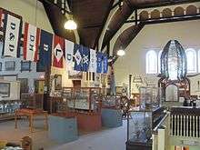
| Yarmouth County Museum |
22 Collins Street, Yarmouth, NS |
43°50′12″N 66°06′58″W / 43.8368°N 66.1161°W / 43.8368; -66.1161 (Yarmouth County Museum) |
|
|
6519 |
|
 |
| Yarmouth's First Hospital |
1 Sycamore Street, Yarmouth, NS |
43°49′31″N 66°07′10″W / 43.8254°N 66.1195°W / 43.8254; -66.1195 (Yarmouth's First Hospital) |
|
|
4790 |
|
|
| Zion Baptist Church |
27 Parade Street, Yarmouth, NS |
43°50′15″N 66°06′59″W / 43.8374°N 66.1163°W / 43.8374; -66.1163 (Zion Baptist Church) |
|
|
7248 |
|
|