El Nido Airport
| El Nido Airport Hulugpaan sang El Nido (Hiligaynon) Paliparan ng El Nido (Filipino) | |||||||||||||||
|---|---|---|---|---|---|---|---|---|---|---|---|---|---|---|---|
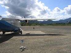 Apron of El Nido Airport | |||||||||||||||
| Summary | |||||||||||||||
| Airport type | Private | ||||||||||||||
| Owner | AirSWIFT | ||||||||||||||
| Operator | Ten Knots Development Corp. | ||||||||||||||
| Serves | El Nido | ||||||||||||||
| Location | Villa Libertad, El Nido, Palawan | ||||||||||||||
| Coordinates | 11°12′07″N 119°25′01″E / 11.20194°N 119.41694°ECoordinates: 11°12′07″N 119°25′01″E / 11.20194°N 119.41694°E | ||||||||||||||
| Map | |||||||||||||||
.svg.png) ENI Location in the Philippines | |||||||||||||||
| Runways | |||||||||||||||
| |||||||||||||||
El Nido Airport (Hiligaynon: Hulugpaan sang El Nido; Filipino: Paliparan ng El Nido) (IATA: ENI), also known as Lio Airport, is an airport serving the general area of El Nido,[1] located in the province of Palawan in the Philippines. It is located in the barangay of Villa Libertad, about 4 kilometres (2 mi) from the poblacion (town proper) of El Nido. This concrete airstrip is owned and operated by AirSWIFT.[4]The gravel runway is now partially coated and used as a taxiway for aircraft.
Airlines and destinations
| Airlines | Destinations |
|---|---|
| AirSWIFT | Caticlan (resumes October 27, 2018)[5], Cebu, Clark, Davao, Busuanga, Manila, Puerto Princesa[6] |
References
- 1 2 Airport information for El Nido, Philippines (IATA: ENI) at Great Circle Mapper.
- ↑ Aerial image of El Nido Airport showing length of runway marked 12/30 at WikiMapia
- ↑ Aerial image of El Nido Airport showing length of second runway at WikiMapia
- ↑ "Air Swift".
- ↑ http://air-swift.com/
- ↑ https://www.routesonline.com/news/38/airlineroute/277298/airswift-adds-puerto-princesa-service-from-march-2018/
External links
This article is issued from
Wikipedia.
The text is licensed under Creative Commons - Attribution - Sharealike.
Additional terms may apply for the media files.