Link'u Link'u
| Link'u Link'u | |
|---|---|
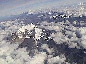 The Illimani massif with Link'u Link'u (center) | |
| Highest point | |
| Elevation | 5,244 m (17,205 ft) [1] |
| Coordinates | 16°39′49″S 67°44′12″W / 16.66361°S 67.73667°WCoordinates: 16°39′49″S 67°44′12″W / 16.66361°S 67.73667°W |
| Geography | |
 Link'u Link'u Location within Bolivia | |
| Location |
Bolivia, La Paz Department |
| Parent range | Andes, Cordillera Real |
Link'u Link'u (Aymara for zig-zag,[2] also spelled Linkho Linkho, Linko Linko) is a 5,244-metre-high (17,205 ft) mountain in the Cordillera Real in the Andes of Bolivia. It is situated in the La Paz Department at the border of the Murillo Province, Palca Municipality, and the Sud Yungas Province, Irupana Municipality. Link'u Link'u lies south-east of the mountain Illimani.[1][3]
References
- 1 2 Bolivian IGM map 1:50,000 Lambate 6044-II
- ↑ "Diccionario Bilingüe Castellano - Aymara, Para: Tercera Edición, 2002". Félix Layme Pairumani. Archived from the original on September 23, 2015. Retrieved October 31, 2014.
- ↑ "Palca". INE, Bolivia. Archived from the original on August 26, 2014. Retrieved October 31, 2014.
This article is issued from
Wikipedia.
The text is licensed under Creative Commons - Attribution - Sharealike.
Additional terms may apply for the media files.