Limey Way
| Limey Way | |
|---|---|
 The Woven Badge | |
| Length | 65 km (40 mi) |
| Location | Derbyshire, England |
| Trailheads | Castleton/Dovedale |
| Use | Hiking |
| Hiking details | |
| Season | All year round |
| Sights | Derbyshire limestone dales |
| Hazards | Some open exposure in winter |
The Limey Way is a 65-kilometre Challenge walk through Derbyshire, England. It starts at Castleton and progresses through 15 major and 5 minor limestone dales to reach the River Dove and Dovedale, the walk's end.
The walk was first described in the 1960s and a Challenge Recorder was appointed: all persons who submitted a full verified account received a woven badge. The walk was later superseded by the Derbyshire Council's own walk, the Limestone Way, which uses the route of the Limey Way down to Thorpe and adds some extra mileage.
Route
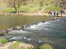
The stepping stones of the River Dove.
The path follows the Derbyshire dales from one into another along the route and in its later stages includes some of the Tissington Trail.
- Castleton car park - grid reference SK150829
- Cave Dale
- Hurdlow Barn
- Old Moor
- Peak Forest - SK114793
- Dam Dale
- Hay Dale
- Wheston - SK133763
- Monksdale
- Millers Dale
- Cressbrook Mill - SK174728
- Monsal Dale
- Deepdale
- Monyash - SK150665
- Lathkill Dale
- Bradford Dale
- Smerrill Grange - SK199619
- Gratton Dale
- Long Dale
- Friden - SK169603
- Biggin Dale
- Wolfcote Dale
- Milldale - SK139547
- Dovedale
- Thorpe Cloud
- River Dove Stepping Stones
FINISH Dovedale Car Park SK146508
References
- Merrill, John N. (1979). The Limey Way. Dalesman Publishing Company.
This article is issued from
Wikipedia.
The text is licensed under Creative Commons - Attribution - Sharealike.
Additional terms may apply for the media files.