Liancourt Rocks
| Disputed islands Other names: Liancourt Islets, Liancourt Islands, Takeshima, Dokdo, Tok Islets | |
|---|---|
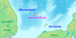 Location of the Liancourt Rocks in the Sea of Japan between Japan and South Korea | |
| Geography | |
 | |
| Location | Sea of Japan |
| Coordinates | 37°14′30″N 131°52′0″E / 37.24167°N 131.86667°E |
| Total islands | 90 (37 permanent land) |
| Major islands | East Islet, West Islet |
| Area |
18.745 hectares (46.32 acres) East Islet: 7.33 hectares (18.1 acres) West Islet: 8.864 hectares (21.90 acres) |
| Highest point |
|
| Administered by | |
| South Korea | |
| County | Ulleung County, North Gyeongsang |
| Claimed by | |
| Japan | |
| Town | Okinoshima, Shimane |
| South Korea | |
| County | Ulleung County, North Gyeongsang |
| Demographics | |
| Population | 50[1] |
The Liancourt Rocks,[lower-alpha 1] also known as Takeshima (竹島, "bamboo island") in Japanese,[2] and Dokdo or Tokto (Korean pronunciation: [tok̚.t͈o]; Hangul: 독도; Hanja: 獨島, "solitary island") in Korean are a group of small islets in the Sea of Japan. While South Korea controls the islets, its sovereignty over them is contested by Japan. South Korea classifies the islets as Dokdo-ri, Ulleung-eup, Ulleung County, North Gyeongsang Province.[3] Japan classifies them as part of Okinoshima, Oki District, Shimane Prefecture.
The Franco-English name of the islets derives from Le Liancourt, the name of a French whaling ship that came close to being wrecked on the rocks in 1849.[4]
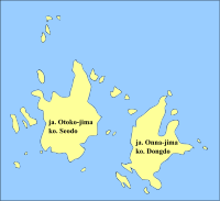
The Liancourt Rocks consist of two main islets and 35 smaller rocks; the total surface area of the islets is 0.187554 square kilometres (46.346 acres), with the highest elevation of 168.5 metres (553 ft) found at an unnamed location on the West Islet.[5]
The Liancourt Rocks lie in rich fishing grounds that may contain large deposits of natural gas.[6]
Geography
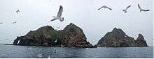
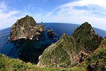
The Liancourt Rocks consist of two main islets and numerous surrounding rocks. The two main islets, called Ojima (男島, "Male Island") and Mejima (女島, "Female Island") in Japanese, and Seodo (Hangul: 서도; Hanja: 西島, "Western Island") and Dongdo (Hangul: 동도; Hanja: 東島, "Eastern Island") in Korean, are 151 metres (495 ft) apart.[5] The Western Island is the larger of the two, with a wider base and higher peak, while the Eastern Island offers more usable surface area.
Altogether, there are about 90 islets and reefs,[5] volcanic rocks formed in the Cenozoic era, more specifically 4.6 to 2.5 million years ago. A total of 37 of these islets are recognized as permanent land.
The total area of the islets is about 187,554 square metres (46.346 acres), with their highest point at 168.5 metres (553 ft) on the West Islet.[5] The western islet is about 88,740 square metres (21.93 acres); the eastern islet is about 73,300 square metres (18.1 acres).[5] The western islet consists of a single peak and features many caves along the coastline. The cliffs of the eastern islet are about 10 to 20 metres (33 to 66 ft) high. There are two large caves giving access to the sea, as well as a crater.
In 2006, a geologist reported that the islets formed 4.5 million years ago and are quickly eroding.[7]
Distances
The Liancourt Rocks are located at about 37°14′N 131°52′E / 37.233°N 131.867°E.[8] The western islet is located at 37°14′31″N 131°51′55″E / 37.24194°N 131.86528°E and the Eastern Islet is located at 37°14′27″N 131°52′10″E / 37.24083°N 131.86944°E.
The Liancourt Rocks are situated at a distance of 211 kilometres (114 nmi) from the main island of Japan (Honshu) and 216.8 kilometres (117.1 nmi) from mainland Korea. The nearest Japanese island, Oki Islands, is at a distance of 157 kilometres (85 nmi).[9], and the nearest Korean island, Ulleung-do, is 87.4 kilometres (47.2 nmi), [10][9].
Climate
Due to their location and small size, the Liancourt Rocks can have harsh weather. If the swell is greater than 3 to 5 metres, then landing is not possible so on average ferries can only dock about once in every forty days.[11] Overall, the climate is warm and humid, and heavily influenced by warm sea currents. Precipitation is high throughout the year (annual average—1,383.4 millimetres or 54.46 inches), with occasional snowfall.[12] Fog is common. In summer, southerly winds dominate. The water around the islets is about 10 °C (50 °F) in early spring, when the water is coldest, warming to about 24 °C (75 °F) in late summer.
Ecology
The islets are volcanic rocks, with only a thin layer of soil and moss.[13] About 49 plant species, 107 bird species, and 93 insect species have been found to inhabit the islets, in addition to local marine life with 160 algal and 368 invertebrate species identified.[14] Although between 1,100 and 1,200 litres of fresh water flow daily, desalinization plants have been installed on the islets for human consumption because existing spring water suffers from guano contamination. Since the early 1970s trees and some types of flowers were planted. According to historical records, there used to be trees indigenous to Liancourt Rocks, which have supposedly been wiped out by overharvesting and fires caused by bombing drills over the islets.[lower-alpha 2][15] A recent investigation, however, identified ten spindle trees aged 100–120 years.[16][17] Cetaceans such as Minke whales, orcas, and dolphins are known to migrate through these areas.[18][19][20]
Pollution and environmental destruction
Records of the human impact on the Liancourt Rocks before the late 20th century are scarce, although both Japanese and Koreans claim to have felled trees and killed Japanese sea lions there for many decades.[21][22]
There is a serious concern for pollution in the seas surrounding the Liancourt Rocks. The sewage water treatment system established on the islets has malfunctioned and sewage water produced by inhabitants of the Liancourt Rocks such as South Korean Coast Guard and lighthouse staff is being dumped directly into the ocean. Significant water pollution has been observed; sea water has turned milky white, sea vegetation is progressively dying off, and calcification of coral reefs is spreading. The pollution is also causing loss of biodiversity in the surrounding seas. In November 2004, eight tons of malodorous sludge was being dumped into the ocean every day.[23] Efforts have since been made by both public[24] and private[25] organizations to help curb the level of pollution surrounding the Rocks.
Demographics and economy
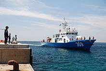
As of February 2017, there are two civilian residents, two government officials, six lighthouse managers, and 40 members of the coast guard living on the islets.[1] Since the South Korean Coast Guard was sent to the islets, civilian travel has been subject to South Korean government approval; they have stated that the reason for this is that the islet group is designated as a nature reserve.
In March 1965, Choi Jong-duk moved from the nearby Ulleungdo to the islets to make a living from fishing. He also helped install facilities from May 1968. In 1981, Choi Jong-duk changed his administrative address to the Liancourt Rocks, making himself the first person to officially live there. He died there in September 1987. His son-in-law, Cho Jun-ki, and his wife also resided there from 1985 until they moved out in 1992. Meanwhile, in 1991, Kim Sung-do and Kim Shin-yeol transferred to the islets as permanent residents, still continuing to live there.
The South Korean government gave its approval to allow 1,597 visitors to visit the islets in 2004. Since March 2005, more tourists have received approval to visit. The South Korean government lets up to 70 tourists land at any one given time; one ferry provides rides to the islets every day.[26] Tour companies charge around 350,000 Korean won per person (about US$250 as of 2009).[27]
Construction
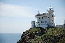
South Korea has carried out a lot of construction work on the Liancourt Rocks. Today, the islands house a lighthouse, a helicopter pad, a large South Korean flag visible from the air, a post box,[28] a staircase, and police barracks.[29] In 2007, two desalinization plants were built capable of producing 28 tons of clean water every day.[30] Both of the major South Korean telecommunications companies have installed cellular telephone towers on the islets.[31]
History
Whaling
American and French whaleships cruised for right whales off the rocks between 1849 and 1892.[32]
Sovereignty dispute
Sovereignty over the islands has been an ongoing point of contention in Japan–South Korea relations. There are conflicting interpretations about the historical state of sovereignty over the islets.
Japanese researchers of these documents have claimed the various references to Usan-do refer at different times to Jukdo, its neighboring island Ulleungdo, or a non-existent island between Ulleungdo and Korea.[lower-alpha 3] The first printed usage of the name Dokdo was in a Japanese log book in 1904.[33]
Other key points of the dispute involve the legal basis that Japan used to claim the islands in 1905, and the legal basis of South Korea's claim on the islands in 1952.
Korean claims are partly based on references to an island called Usan-do (우산도, 于山島/亐山島) in various medieval historical records, maps, and encyclopedia such as Samguk Sagi, Annals of Joseon Dynasty, Dongguk Yeoji Seungnam, and Dongguk munhon bigo. According to the Korean view, these refer to today's Liancourt Rocks.
North Korea and South Korea agree that the islands are Korean territory and reject Japan's claim.[34]
See also
Notes
- ↑ "Since the end of World War II, Japan and Korea have contested ownership of these islets, given the name Liancourt Rocks by French whalers in the mid-1800s and called that by neutral observers to this day" (Fern 2005, p. 78).
- ↑ "There are records attesting to the existence of trees [on Liancourt Rocks] in the past" (BAEK In-ki, SHIM Mun-bo & Korea Maritime Institute 2006, p. 48)
- ↑ "Such description... rather reminds us of Utsuryo Island" (para. 2); "A study... criticizes... that Usan Island and Utsuryo Island are two names for one island." (para. 3); and "that island does not exist at all in reality" (para. 4 – "10 Issues of Takeshima, MOFA (Article 2)" (PDF). Ministry of Foreign Affairs (Japan). February 2008. p. 4. Archived from the original (PDF) on 13 September 2008.
Inline citations
- 1 2 "Dokdo Residents". Gyeongsangbuk-do Province. Retrieved February 13, 2017.
- ↑ BBC staff 2006.
- ↑ "Act 1395 amending Chapter 14-2, Ri-Administration under Ulleung County, Local Autonomy Law, Ulleung County (울릉군리의명칭과구역에관한조례 [개정 2000. 4. 7 조례 제1395호])". "Pursuant to Act 1395 amending Chapter 14-2, Ri-Administration under Ulleung County, Local Autonomy Law, Ulleung County, passed March 20, 2000, enacted April 7, 2000, the administrative designation of Dokdo addresses as 42 to 76, Dodong-ri, Ulleung-eup, Ulleung County, North Gyungsang Province, is changed to address 1 to 37, Dokdo-ri, Ulleung-eup, Ulleung County, North Gyungsang Province." "2000년 4월 7일 울릉군조례 제1395호로 독도리가 신설됨에 따라 독도의 행정구역이 종전의 경상북도 울릉군 울릉읍 도동리 산42~76번지에서 경상북도 울릉군 울릉읍 독도리 산1~37번지로 변경 됨.""조회". Archived from the original on 1 March 2009. Retrieved 12 September 2008.
- ↑ Kirk 2008.
- 1 2 3 4 5 Gyeongsangbuk-do Province 2017b.
- ↑ BBC staff 2008.
- ↑ ""독도ㆍ울릉도 `침몰하고 있다'"<손영관교수>". Yeonhap News. 1 December 2006. Retrieved 1 January 2015.
- ↑ Gyeongsangbuk-do Province 2017c.
- 1 2 "The Issue of Takeshima". Ministry of Foreign Affairs of Japan. Retrieved 26 October 2012.
- ↑ BAEK In-ki, SHIM Mun-bo & Korea Maritime Institute 2006, pp. 20-22.
- ↑ Gyeo ngbuk Province 2001b.
- ↑ Gyeongsangbuk-do Province 2017a.
- ↑ Gyeo ngbuk Province 2001a.
- ↑ "독도 자연생태계 정밀조사결과(요약)" [A comprehensive survey of the natural ecosystems of Liancourt Rocks (synopsys)]. Archived from the original on 22 July 2011.
- ↑ Lee, Kyu Tae (27 June 2003), "(pseud.)The Trees of Liancourt Rocks", Chosun Daily
- ↑ "Indigenous Spindle Tree Colony Found on Liancourt Rocks 독도 자생 사철나무 군락 첫 발견".
- ↑ "독도 자생 사철나무 100년 이상 된 자생식물" [Liancourt Rock Spindle Trees Over 100 Year Olds].
- ↑ "독도수비 해경, 그물걸린 범고래 구조 - 멸종위기 해양생물 보호 적극적인 조치 기대". K07011002K: ENVIROASIA. 2007. Archived from the original on 19 January 2015. Retrieved 10 June 2014.
- ↑ . Koike T., translator. "独島警備の海洋警察、網にかかったシャチ救出". K07011002J: ENVIROASIA. 2007. Archived from the original on 14 July 2014. Retrieved 10 June 2014.
- ↑ 2017. "동해 고래, 한미관계 뿐 아니라 독도 역사와도 연결". Retrieved on August 21, 2017
- ↑ 국민일보 (Gookmin Daily). "독도‘실효적 지배’새 근거 (New Evidence of effective control), 1890년 이전부터 독도서 강치잡이 (Sea lion hunting before 1890) [26 July 2006"]
- ↑ Japan: Outline of Takeshima Issue
- ↑ "독도 오수정화시설이 동해바다 오염 주범?". Imaeil.
- ↑ "Three-Month Cleanup for Dokdo's Marine Garbage Starts from June 2 독도 바다쓰레기 청소 6월2일부터 석달간".
- ↑ "나무 심고 오물 줍고…아름다운 '독도 사랑'".
- ↑ Ha 2008.
- ↑ Life in Dokdo Cyber Dokdo
- ↑ Vladivostok News report Archived 23 August 2009 at the Wayback Machine.
- ↑ Sang-Hun 2008.
- ↑ KOIS staff 2007a.
- ↑ KOIS staff 2007.
- ↑ Cambria, of New Bedford, Apr. 29, 1849, Nicholson Whaling Collection; Cape Horn Pigeon, of New Bedford, Apr. 19, 1892, Kendall Whaling Museum.
- ↑ ""Logbooks of the Japanese Warship Niitaka September 25th 1904"<軍艦新高行動日誌>". Dokdo Takeshima The Historical Facts of the Dispute. 1 September 2008.
- ↑ Agency, United States Central Intelligence; Office, Government Publications (2016). The World Factbook 2016-17. Government Printing Office. p. 406. ISBN 9780160933271.
References
- BAEK In-ki; SHIM Mun-bo; Korea Maritime Institute (December 2006), A study of Distance between Ulleungdo and Dokdo and Ocean Currents (울릉도와 독도의 거리와 해류에 관한 연구), pp. 20–22, ISBN 978-89-7998-340-1, archived from the original on 12 January 2013
- BBC staff (20 April 2006), Seoul and Tokyo hold island talks, BBC
- BBC staff (27 July 2008), "Island row hits Japanese condoms", BBC News
- Fern, Sean (Winter 2005), "Tokdo or Takeshima? The International Law of Territorial Acquisition in the Japan-Korea Island Dispute", Stanford Journal of East Asian Affairs, 5 (1)
- Gyeongsangbuk-do Province (28 September 2017a), "Climate", Dokdo, Beautiful island of Korea, Korean Government
- Gyeongsangbuk-do Province (28 September 2017b), "Composition", Dokdo, Beautiful island of Korea, Korean Government
- Gyeongsangbuk-do Province (28 September 2017c), "Location", Dokdo, Beautiful island of Korea, Korean Government
- Gyeo ngbuk Province (2001a), "Natural Environment", Cyber Dokdo, Korean Government
- Gyeo ngbuk Province (2001b), "Visit Dokdo", Cyber Dokdo, Korean Government
- Ha, Michael (26 August 2008), "A Unique Trip to Dokdo — Islets in the News", The Korea Times, archived from the original on 4 March 2016
- Kirk, Donald (26 July 2008), Seoul has desert island dreams, Asia Times Online
- KOIS staff (12 January 2007), Cell phones give Korean ring to Dokdo, Korea.net Korean Culture and Information Service (KOIS), archived from the original on 2 March 2009
- KOIS staff (12 June 2007a), Doosan pours big drink for Dokdo residents, Korea.net Korean Culture and Information Service (KOIS), archived from the original on 2 March 2009
- Sang-Hun, Choe (28 August 2008), "A fierce Korean pride in a lonely group of islets", International Herald Tribune, archived from the original on 28 August 2008
- Yonhap staff (20 July 2011), N. Korea denounces Japan's vow to visit island near Dokdo, Yonhap News Agency
External links
| Wikimedia Commons has media related to Liancourt Rocks. |

- Takeshima (Shimane Prefectural Government, Japan)
- The Issue of Takeshima(The Issue of Takeshima, Asia, Regional Affairs, The Ministry of Foreign Affairs, Japan)
- 10 Issues of Takeshima (Northeast Asia Division, Asian and Oceanian Affairs Bureau, The Ministry of Foreign Affairs, Japan)
- Dokdo Official Website
- Dokdo Research Institute (Korea)
Coordinates: 37°14′30″N 131°52′00″E / 37.24167°N 131.86667°E
Territorial disputes in East, South, and Southeast Asia | |||||||||
|---|---|---|---|---|---|---|---|---|---|
| |||||||||
| |||||||||