Leoganger Ache
| Leoganger Ache | |
|---|---|
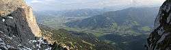 Lower reaches of the Leoganger Ache, with Saalfelden on the left and Leogang, seen from the Passau Hut, view to the south | |
| Location | Pinzgau, Salzburg (Land), Austria |
| Physical characteristics | |
| Main source |
Schwarzleobach ∞ Grießner Bach:: in Hütten (Leogang) ca. 960 m (AA) 47°26′30″N 12°42′20″E / 47.44167°N 12.70556°E |
| River mouth |
Saalach near Uttenhofen (Saalfelden) 720 m (AA) 47°26′22″N 12°49′23″E / 47.43944°N 12.822917°ECoordinates: 47°26′22″N 12°49′23″E / 47.43944°N 12.822917°E |
| Length | 15 km |
| Basin features | |
| Progression | Saalach→ Salzach→ Inn→ Danube→ Black Sea |
| Landmarks | Villages: Leogang, Saalfelden (Uttenhofen) |
The Leoganger Ache is a left tributary of the River Saalach and drains the valley of the same name, the Leoganger Tal. After appr. 15 km it joins the Saalach 1.7 km north of Saalfelden.
It originates near the border with Tyrol and flows from west to east. Exactly in the middle it passes through the village of Leogang.
The Leoganger Ache is formed near the Tyrolean border in Hütten in the municipality of Leogang at a height of 960 m from:
- the Schwarzleobach stream, which flows from the southwest below the Spielberghorn mountain in the Tyrolean Slate Alps (north of Saalbach) having risen on the Spielbergtörl, at about 1,600 m, and...
- the Grießner Bach, which flows down from the Grießen Pass at 970 m from the Grießensee and Grießener Moor.
Including the Schwarzleobach the river is 22 km long.
The Leoganger Valley runs from west to east and falls openly and gently into the Saalfelden Basin, passing the village of Leogang about halfway down.
Northwest of Saalfelden, in the cadastral municipality of Uttenhofen, it discharges into the Saalach (at a triple confluence with the Urslau).
Its northern, right hand tributaries comprise several mountain streams that drain the limestone massifi of the Leoganger Steinberge (the Grießbach and Weissbach empty into the Grießner Bach, the Birnbach from Birnhorn joins at Leogang and the Weissbach at Ecking). From the Slate Alps the main streams are the Schwarzbach (with the Dunkelkendlbach from the Asitz and the Klammbach from the Halderbergkogel).
The B 164 Hochkönig Road (which comes from Bischofshofen via Dienten and Saalfelden) runs along the Leoganger Valley over the Grießen Pass and via Fieberbrunn to St. Johann in Tirol – it is the only internal Austria link between Tyrol and the east which does not cross a high Alpine pass, but is also linked to Salzburg via the Little German Corner.