Lefagaoali'i
| Lefagaoali'i | |
|---|---|
| Village | |
 View of Lefagaoali'i from the south at Mata o le Alelo pool | |
 Lefagaoali'i | |
| Coordinates: 13°28′1″S 172°25′16″W / 13.46694°S 172.42111°WCoordinates: 13°28′1″S 172°25′16″W / 13.46694°S 172.42111°W | |
| Country |
|
| District | Gagaifomauga |
| Population (2006) | |
| • Total | 469 |
| Time zone | -11 |
Lefagaoali'i is a village on the central north coast of Savai'i island in Samoa.[1] The village is in the electoral district of Gagaifomauga.[2]
The settlement is situated on a thin spit of land with the ocean on the north side and an inland lake with mangroves on the south side which flows out to the open sea through a gap at the west end of the village. The main island road circling Savai'i passes the village at the east end at the bottom of a steep hill. At the base of the cliffs at the east end of the village, and by the sea, are freshwater springs used by the people of Lefagaoali'i and neighbouring villages.
To the east of Lefagaoali'i are the villages of Samauga and Safotu. On the south and towards the west are Safune, Faletagaloa and Sasina.
There are reef breaks for surfing directly in front of the village although the waves are not for the inexperienced.
References
Notes
- 2006 Samoa Population Census Retrieved 27 October 2009
Traditional center: Safotu | ||
| Villages | 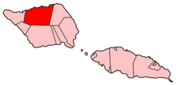 | |
| Notable landmarks | ||
| Conservation & Environment | ||
| Education & Schools | ||
| Electoral constituencies: Faipule Districts |
| |