Lebap Region
Coordinates: 39°0′N 63°0′E / 39.000°N 63.000°E
| Lebap | |
|---|---|
| Region | |
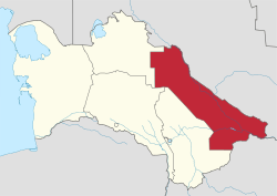 Lebap region in Turkmenistan | |
| Country | Turkmenistan |
| Capital | Türkmenabat |
| Area | |
| • Total | 93,730 km2 (36,190 sq mi) |
| Population (2005) | |
| • Total | 1,334,500 |
| • Density | 14/km2 (37/sq mi) |
Lebap Region (Turkmen: Lebap welaýaty/Лебап велаяты from the Persian لب آب Labe âb) is one of the regions of Turkmenistan. It is in the northeast of the country, bordering Afghanistan, Uzbekistan along the Amu Darya. Its capital is Türkmenabat (formerly named Çärjew). It has an area of 93,730 square kilometers, and a population of 1,334,500 people (2005 est.).[1]
The name Lebap is Turkmenized form of the Persian Lab-e āb (لب آب) which means "riverside" and has long been used to designate the middle reaches of the Amu Darya river.[2]
It contains the Repetek Nature Reserve and the Köýtendag Nature Reserve, which has Turkmenistan's highest mountain, Aýrybaba (3137 meters).
Region is located alongside of Amuderya river, Gyzylgum desert is located east side of river and Garagum desert is located west side of river. Thanks to sunny whether and abundance of water resources state produced one of the highest quality cotton and wheat in the world.
Region is also rich for its natural resources such as natural gas (the Malai Gas Field) and other mines. China-Turkmenistan gas-pipeline started from this region. Lebap Regions Bagtiyarlik natural gas field is main supplier of Chinese natural gas.
Districts
As of November 27, 2017, Lebap Province (Lebap welaýaty) is subdivided into 10 districts (etrap, plural etraplar):[3][4][5]
- Çarjew (formerly Serdarabat)
- Darganata (formerly Birata)
- Dänew (formerly Galkynyş)
- Döwletli
- Farap
- Halaç
- Hojambaz
- Kerki (formerly Atamyrat)
- Köýtendag
- Saýat
As of that date, four districts (Beýik Türkmenbaşy, Garaşsyzlyk, Garabekwül, and Sakar) were abolished and their territories absorbed by other districts.
As of January 1, 2017, the province included 15 cities (города or şäherler), 23 towns (посёлки or şäherçeler), 106 rural or village councils (сельские советы or geňeşlikler), and 430 villages (села, сельские населенные пункты or obalar).[4][3]
See also
References
- ↑ Statistical Yearbook of Turkmenistan 2000-2004, National Institute of State Statistics and Information of Turkmenistan, Ashgabat, 2005.
- ↑ UNESCO., Ahmad Hasan Dani, and V. M. Masson. 1992. History of civilizations of Central Asia. Vol. V. Paris: Unesco. p.128
- 1 2 Türkmenistanyň Mejlisi (2010–2018). "Türkmenistanyň dolandyryş-çäk birlikleriniň Sanawy". Türkmenistanyş Mejlisiniň Karary. Ashgabat. This document is reproduced online at https://wiki.openstreetmap.org/wiki/Districts_in_Turkmenistan.
- 1 2 "Административно-территориальное деление Туркменистана по регионам по состоянию на 1 января 2017 года".
- ↑ "Внесены изменения в административно-территориальное деление Лебапского велаята". 27 November 2017.
External links
Places adjacent to Lebap Region | |
|---|---|
Region (capital) | |
|