Lantau Peak
| Lantau Peak | |
|---|---|
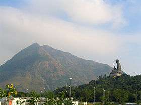 The Lantau Peak rises high above the Tian Tan Buddha. | |
| Highest point | |
| Elevation | 934 m (3,064 ft) |
| Prominence | 934 m (3,064 ft) |
| Coordinates | 22°14′59.17″N 113°55′16.69″E / 22.2497694°N 113.9213028°ECoordinates: 22°14′59.17″N 113°55′16.69″E / 22.2497694°N 113.9213028°E |
| Geography | |
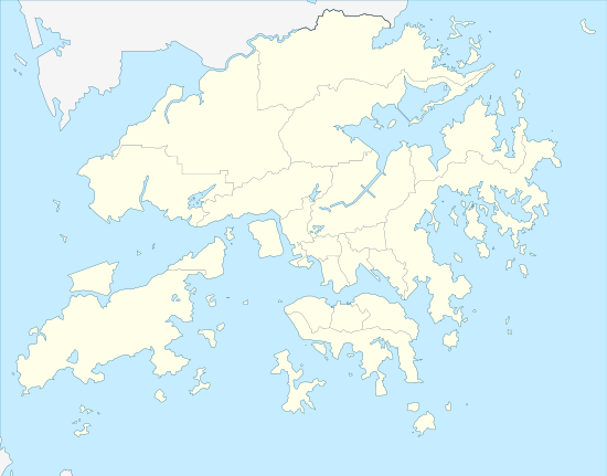 Lantau Peak Location of Lantau Peak in Hong Kong | |
| Location | Lantau Island, Hong Kong |
Lantau Peak or Fung Wong Shan (Chinese: 鳳凰山, literally "Phoenix Mountain") is the second highest peak in Hong Kong and the highest point on Lantau Island, with a height of 934 metres (3,064 ft) above sea level. It is most famous for the sunrise scenery viewed from the summit.
Name origin
The mountain is actually made up of a pair of peaks, one is known as "Fung Shan" (male phoenix mountain) and the other is "Wong Shan" (female phoenix mountain), together they form "Fung Wong Shan".
Climate
Lantau Peak is located in central Lantau Island, with an elevation of 934 meters above sea level (23 metres shorter than Tai Mo Shan, Hong Kong's highest peak). Under the Köppen climate classification, Lantau Peak features a subtropical highland climate. Due to its elevation, strong winds and fog occur throughout the year. Winter is cold with temperatures often dip below 0 ° C; summer is warm with temperatures reaching tops of 18-22 ° C, which can be considered as a summer resort in Hong Kong(since Hong Kong is usually really hot during summer); the spring is cool to cold but very humid, while the autumn is cool and dry, but also because of its climate similar to Tai Mo Shan, winter might experiences frost and snow and other winter special weather phenomena, even more than Tai Mo Shan and Ngong Ping also much more cold (because it is isolated from urban areas and often experiences strong winds throughout the year). Because there is no weather station at the top of Lantau Peak, the Ngong Ping Weather Station of the Hong Kong Observatory can only be used as reference for its temperature. The temperature in the vicinity of Ngong Ping is lower than that at Chek Lap Kok. It is estimated that the temperature of Lantau Peak is about 7 ℃ lower than that of Ngong Ping.
| Climate data for Lantau Peak | |||||||||||||
|---|---|---|---|---|---|---|---|---|---|---|---|---|---|
| Month | Jan | Feb | Mar | Apr | May | Jun | Jul | Aug | Sep | Oct | Nov | Dec | Year |
| Average high °C (°F) | 8.3 (46.9) |
10.2 (50.4) |
11.9 (53.4) |
14.2 (57.6) |
16.6 (61.9) |
17.8 (64) |
18.5 (65.3) |
19.2 (66.6) |
18.7 (65.7) |
16.6 (61.9) |
13.5 (56.3) |
10.0 (50) |
14.6 (58.3) |
| Daily mean °C (°F) | 4.9 (40.8) |
7.2 (45) |
9.0 (48.2) |
13.1 (55.6) |
14.8 (58.6) |
16.3 (61.3) |
16.9 (62.4) |
17.1 (62.8) |
16.3 (61.3) |
13.8 (56.8) |
10.6 (51.1) |
6.8 (44.2) |
12.2 (54) |
| Average low °C (°F) | 2.3 (36.1) |
4.9 (40.8) |
6.8 (44.2) |
10.0 (50) |
13.1 (55.6) |
14.7 (58.5) |
15.3 (59.5) |
15.3 (59.5) |
14.5 (58.1) |
11.9 (53.4) |
8.4 (47.1) |
4.2 (39.6) |
10.1 (50.2) |
| Source: Climate Data for Lantau Peak — Hong Kong Observatory | |||||||||||||
Sunrise
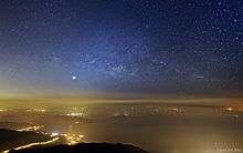
The peak is one of the most popular hiking spots in Hong Kong and can be reached by the Lantau Trail.
Most hikers begin their climb from the Youth Hostel near Ngong Ping before dawn in order to catch a view of the sunrise.
References
- The Chinese Phoenix Fenghuang
See also
| Wikimedia Commons has media related to Lantau Peak. |