Langdale, British Columbia
| Langdale | |
|---|---|
| Unincorporated community | |
 Langdale Ferry Terminal | |
 Langdale Location in British Columbia | |
| Coordinates: 49°26′00″N 123°28′00″W / 49.43333°N 123.46667°WCoordinates: 49°26′00″N 123°28′00″W / 49.43333°N 123.46667°W | |
| Country |
|
| Province |
|
| Regional district | Sunshine Coast |
| Area code(s) | 604 |
Langdale is a small community on the Sunshine Coast of southern British Columbia, Canada. It is set in a verdant environment characteristic of many small BC communities. It plays host to a ferry terminal (also called Langdale) which serves as the point of entry for most vehicles entering the Sunshine Coast region.
Langdale is a small residential community and has no significant industry other than the ferry terminal.
It is also the location of school district 46's Langdale Elementary School.
Located north of Langdale is the small community of Williamson's Landing.
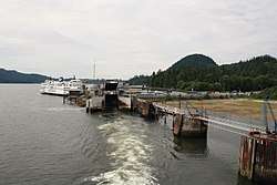
Langdale Ferry Terminal
Its main feature is the BC Ferries terminal that links the Sunshine Coast to Vancouver via Horseshoe Bay, with connecting foot-passenger service to Keats Island and Gambier Island. There is only a single berth in Langdale.
British Columbia Highway 101 is connected to this terminal.
External links