Lanciego/Lantziego
| Lanciego/Lantziego | ||
|---|---|---|
| Municipality | ||
| Lantziego | ||
 | ||
| ||
 Lanciego/Lantziego Location in Spain | ||
| Coordinates: 42°34′N 02°31′W / 42.567°N 2.517°WCoordinates: 42°34′N 02°31′W / 42.567°N 2.517°W | ||
| Country |
| |
| Autonomous community |
| |
| Province | Álava | |
| Region | Cuadrilla de Laguardia-Rioja Alavesa | |
| Founded | 1630 | |
| Government | ||
| • Alcalde | Alfonso Luis Gonzalez Eguilaz (Partido Nacionalista Vasco) | |
| Area | ||
| • Total | 24.20 km2 (9.34 sq mi) | |
| Elevation | 541 m (1,775 ft) | |
| Time zone | UTC+1 (CET) | |
| • Summer (DST) | UTC+2 (CEST) | |
| Postal code | 01308 | |
| Official languages | Basque, Spanish | |
| Website | www.lanciego.org | |

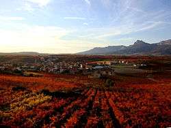
Lanciego (Basque: Lantziego) is a town and municipality located in the province of Álava, in the Basque Country, northern Spain. The municipality of Lanciego in Rioja Alavesa consists of three towns: Lanciego, Assa and Viñaspre. Lanciego has a total population of approximately 650. Its name derives from Lantzeaga (place of culture) and Lantze = cultivate.
Places of interest
Religious Monuments
- The church of San Acisclo y Santa Victoria.
- The Hermitage of La Virgen del Campo.
Recreational Facilities
- The public open air swimming pools.
- The polideportivo leisure centre.
- The old Frontón.
History
Lanciego (in Basque Lantziego), located in Rioja Alavesa, settles on a relatively flat area, in a small vale at the feet of the Cantabrian Sierra. It is watered by several creeks and is surrounded by lush vineyards from which the majority of local income is made. From its origin until the year 1630 it was a part of the jurisdiction of Laguardia, and in 1630 it obtained the title of town. The first documented appearance of the municipality is in the year 1257 and in 1366 its demographic information is first documented, being a part of the kingdom of Navarre.