Lamsenspitze
| Lamsenspitze | |
|---|---|
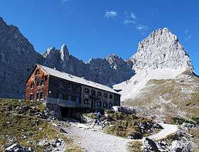 Lamsenjoch Hut (Lamsenjochhütte) in front of the Lamsenspitze | |
| Highest point | |
| Elevation | 2,508 m (8,228 ft) |
| Isolation | 1.7 kilometres (1.1 mi) |
| Coordinates | 47°22′58″N 11°35′28″E / 47.382778°N 11.591111°ECoordinates: 47°22′58″N 11°35′28″E / 47.382778°N 11.591111°E |
| Geography | |
| Parent range | Alps, Karwendel |
| Climbing | |
| First ascent | Markus Vincent Lipold (1843) |
| Easiest route | alpine hike |

Lamsenspitze (elevation 2,508 m (8,228 ft)) is a summit of the Karwendel range in the Austrian state of Tyrol.
Alpinism
The easiest route to the summit is a steep track secured with fixed wire ropes starting at the Lamsenjoch Hut (Lamsenjochhütte) at the bottom of the steep eastern wall of the Lamsenspitze. Also a garden for climbers can be found there.
A second prominent route goes through a Via ferrata of mid difficulty that includes a climb through a tunnel called Brudertunnel or Lamstunnel. The Lamsenjoch Hut is reachable most easily starting from Pertisau or from the Ahornboden as a mountain hike.
There are two crosses at the summit, one of them can be seen from the Lamsenjoch Hut.
| Wikimedia Commons has media related to Lamsenspitze. |
This article is issued from
Wikipedia.
The text is licensed under Creative Commons - Attribution - Sharealike.
Additional terms may apply for the media files.