Schaalsee
| Schaalsee | |
|---|---|
 | |
| Location | Schleswig-Holstein and Mecklenburg-Vorpommern |
| Coordinates | 53°35′25″N 10°54′52″E / 53.59028°N 10.91444°ECoordinates: 53°35′25″N 10°54′52″E / 53.59028°N 10.91444°E |
| Primary outflows | Schaalsee-Kanal, Schaale |
| Catchment area | 180 km2 (69 sq mi) |
| Basin countries | Germany |
| Surface area | 23.5 km2 (9.1 sq mi) |
| Average depth | 17 m (56 ft) |
| Max. depth | 71.5 m (235 ft) |
| Residence time | 5 to 10 years |
| Surface elevation | 35 m (115 ft) |
| Islands | (Kampenwerder, Stintenburginsel, Rethwiese) |
| Settlements | Zarrentin, Seedorf |
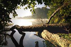
Schaalsee is a 24 km2 (9.3 sq mi) lake in Germany. It forms part of the border between Schleswig-Holstein (district Herzogtum Lauenburg) and Mecklenburg-Vorpommern (districts Ludwigslust-Parchim and Nordwestmecklenburg). The town of Zarrentin is located on its southern shores. Other municipalities on the lake are Seedorf, Sterley, Salem, Kittlitz and Kneese.
It was declared a biosphere reserve in 2000 (309 km²).
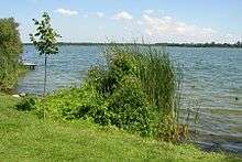
Schaalsee in Zarrentin
External links
- Schaalsee (in German)
- Biosphärenreservat Schaalsee (in German)
- Nixdorf, B.; et al. (2004), "Schaalsee", Dokumentation von Zustand und Entwicklung der wichtigsten Seen Deutschlands (in German), Berlin: Umweltbundesamt, p. 71
- Agroforstprojekt am Schaalsee
Biosphere reserves in Germany | ||
|---|---|---|
| ||
This article is issued from
Wikipedia.
The text is licensed under Creative Commons - Attribution - Sharealike.
Additional terms may apply for the media files.