Lac de Paladru
| Lac de Paladru | |
|---|---|
 | |
| Location | Isère |
| Coordinates | 45°27′N 5°32′E / 45.450°N 5.533°ECoordinates: 45°27′N 5°32′E / 45.450°N 5.533°E |
| Primary inflows | Courbon, Pin |
| Primary outflows | la Fure |
| Basin countries | France |
| Max. length | 5,300 m (17,400 ft) |
| Max. width | 950 m (3,120 ft) |
| Surface area | 3.9 km2 (1.5 sq mi) |
| Average depth | 25 m (82 ft) |
| Max. depth | 33 m (108 ft) |
| Water volume | 97 million cubic metres (79,000 acre⋅ft) |
| Residence time | 3.6 years |
| Settlements | Paladru, Charavines, Le Pin, Bilieu, Montferrat |
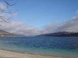
Lake Paladru (Lac de Paladru) is a small lake located in the Isère département, near Charavines, in France.
The lake was formed by the glacier of the Rhône. It is 6 km long and 1.2 km wide when full. Maximum depth: 33m.
External links
- The farmer-knights of Paladru Lake

This article is issued from
Wikipedia.
The text is licensed under Creative Commons - Attribution - Sharealike.
Additional terms may apply for the media files.