Lake Itkul
| Itkul | |
|---|---|
 lake Itkul | |
| Coordinates | 56°05′N 60°18′E / 56.09°N 60.3°E |
| Primary inflows | Dolgaya, Shardatma, Zyuzelka, Karabayka, Kamenuchka |
| Primary outflows | Istok |
| Catchment area | 154 km2 (0 sq mi) |
| Basin countries | Russia |
| Max. length | 7 km (4.3 mi) |
| Max. width | 5 km (3.1 mi) |
| Surface area | 30 km2 (12 sq mi) |
| Average depth | 7.8 m (26 ft) |
| Max. depth | 16.6 m (54 ft) |
| Water volume | 0.0234 km3 (0 cu mi) |
| Surface elevation | 273 m (896 ft) |
| Frozen | November–May |
| Islands | 1 |
| Settlements | Verkhny Ufaley |
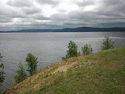
Lake Itkul is situated in the north of the Chelyabinsk Oblast, 20 kilometers from the town of Verkhny Ufaley. Lake Itkul was declared a natural monument.
The lake is surrounded by low summits of the Ural Mountains, the highest of them being Karabayka (544 m) on the southwestern shore of Lake Itkul. Here in Lake Itkul small river flows Karabayka.
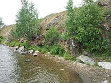
Lakeside Itkul
This article is issued from
Wikipedia.
The text is licensed under Creative Commons - Attribution - Sharealike.
Additional terms may apply for the media files.