Lake D'Arbonne State Park
| Lake D'Arbonne State Park | |
|---|---|
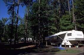 Camping area at the park | |
 Map of Louisiana, United States of America | |
| Location | Union Parish, Louisiana, United States of America |
| Coordinates | 32°47′12″N 92°29′24″W / 32.7868°N 92.4899°WCoordinates: 32°47′12″N 92°29′24″W / 32.7868°N 92.4899°W[1] |
| Area | 655 acres (2.65 km2; 1.023 sq mi)[1] |
| Established | 1967[2] |
| Governing body | Louisiana Office of State Parks |
|
web | |
Lake D'Arbonne State Park is 655 acres (2.65 km2) in size and lies in a hilly region adjacent to Lake D'Arbonne in Union Parish, Louisiana, USA. It can be reached by taking La. Hwy. 2 west from Farmerville about 5 miles (8.0 km), then left (south) on Evergreen Road, which leads directly into the park.
The state park is a popular place to fish, camp and hike. Accommodations at the park include 58 campsites (51 improved, 7 deluxe), 16 cabins and 2 lodges. A network of hiking and walking trails go throughout the park. The four main trails are color-coded Orange, Green, White and Blue. Visitors may rent boats, including canoes, by the day or hour. It is also the only State Park in Louisiana with tennis courts.
Wildlife is abundant in the mixed pine-hardwood forest at Lake D'Arbonne and deer sightings occur regularly.
References
- 1 2 "Lake D'Arbonne State Park - Louisiana Office of State Parks". Archived from the original on 9 June 2011. Retrieved 17 January 2011.
- ↑ "Fall General Meeting at Lake D'Arbonne" (PDF). Pack & Paddle. Ozark Society (Summer): 7. June 2009. Archived from the original (PDF) on 2010-02-02. Retrieved 2012-03-31.
External links
| Wikimedia Commons has media related to Lake D'Arbonne State Park. |