Lake Claiborne
| Lake Claiborne | |
|---|---|
 | |
 Lake Claiborne Map of Louisiana, United States of America | |
| Location | Claiborne Parish, Louisiana, United States of America |
| Coordinates | 32°43′23″N 92°55′13″W / 32.7231°N 92.9203°WCoordinates: 32°43′23″N 92°55′13″W / 32.7231°N 92.9203°W |
| Basin countries | United States |
| Surface area | 6,400 acres (26 km2) |
| Water volume | 99,500 acre⋅ft (0.1227 km3) |
| Surface elevation | 185.0 ft (56.4 m) MSL |
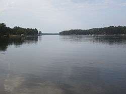
Lake Claiborne is a reservoir located near the town of Homer, Louisiana, United States. Isolated in a rural area, it is a popular man-made fishing area that has a combined estimated area of 6,400 acres (26 km2).[1] Lake Claiborne State Park, a Louisiana state maintained camping and recreation area, lies on southern shore of the lake. The state park also offers two world class disc golf courses.
The lake was created by the construction of Clairborne Lock and Dam by the United States Army Corps of Engineers in 1970. The lock is for water management and navigation; no hydroelectric power is produced here.[2] The dam was built during the terms of Governors Jimmie Davis and John McKeithen.[3]
References
- ↑ Office of State Parks - Teacher's Guide. Louisiana State Parks. 2002.
- ↑ "Archived copy". Archived from the original on 2012-09-11. Retrieved 2012-07-13.
- ↑ Lake Claiborne spillway sign at Lake Claiborne, Louisiana Dept of Public Works
External links
This article is issued from
Wikipedia.
The text is licensed under Creative Commons - Attribution - Sharealike.
Additional terms may apply for the media files.