Lahstedt
| Lahstedt | ||
|---|---|---|
| part of Ilsede | ||
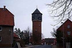 Water tower | ||
| ||
 Lahstedt | ||
| Coordinates: 52°15′N 10°13′E / 52.250°N 10.217°ECoordinates: 52°15′N 10°13′E / 52.250°N 10.217°E | ||
| Country | Germany | |
| State | Lower Saxony | |
| District | Peine | |
| Municipality | Ilsede | |
| Area | ||
| • Total | 43.6 km2 (16.8 sq mi) | |
| Elevation | 97 m (318 ft) | |
| Population (2013-12-31) | ||
| • Total | 9,985 | |
| • Density | 230/km2 (590/sq mi) | |
| Time zone | CET/CEST (UTC+1/+2) | |
| Postal codes | 31246 | |
| Dialling codes | 05172, 05174 | |
| Vehicle registration | PE | |
| Website | www.lahstedt.de | |

Lahstedt is a former municipality in the district of Peine, in Lower Saxony, Germany. It was situated approximately 11 km south of Peine, and 20 km west of Braunschweig.
Lahstedt was formed in 1971 by merging the five villages of Adenstedt, Gadenstedt, Groß Lafferde, Münstedt and Oberg. "Lahstedt" itself was an artificial name, but not a population centre. Since 1 January 2015 its subdivisions are part of the municipality Ilsede.
Municipal subdivisions
- Adenstedt
- Gadenstedt
- Groß Lafferde
- Münstedt
- Oberg
References
External links
![]()
This article is issued from
Wikipedia.
The text is licensed under Creative Commons - Attribution - Sharealike.
Additional terms may apply for the media files.