Lake of Gruyère
| Lake of Gruyère Lac de la Gruyère | |
|---|---|
 | |
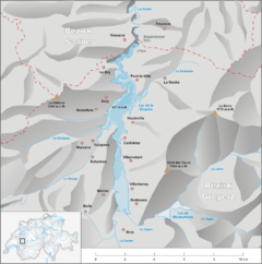 Map | |
| Coordinates | 46°39′N 7°06′E / 46.650°N 7.100°ECoordinates: 46°39′N 7°06′E / 46.650°N 7.100°E |
| Type | reservoir |
| Primary inflows | Saane/Sarine, Sionge, Jogne |
| Primary outflows | Saane/Sarine |
| Catchment area | 954 km2 (368 sq mi) |
| Basin countries | Switzerland |
| Max. length | 13.5 km (8.4 mi) |
| Surface area | 9.60 km2 (3.71 sq mi) |
| Max. depth | 75 m (246 ft) |
| Water volume | 220×106 m3 (180,000 acre⋅ft) |
| Surface elevation | 677 m (2,221 ft) (max) |
| Islands | Ile d'Ogoz, four other islets |
| Settlements | see article |
Lake of Gruyère (French: Lac de la Gruyère; German: Lac de la Gruyère or Greyerzersee) is an artificial lake in the La Gruyère region of the Canton of Fribourg, Switzerland.
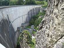
The reservoir was formed between the cities of Bulle and Fribourg, by building the Rossens Dam on the Sarine river in 1948. The arch dam has a height of 83 m and a crest length of 320 m. The reservoir filled in about four months after completion. The dam is operated by the Groupe E SA.
The remains of the castle of Pont (or Pont-en-Ogoz) and a chapel are located on the Ile d'Ogoz, one of the five islets in the lake.
The "Viaduc du Lac de Gruyère" of the A12 motorway was built in the 1970s. The bridge has a total length of 2043 m and crosses three valleys, including two arms of the lake.
| Western shore | Eastern shore |
|---|---|
|
External links
| Wikimedia Commons has media related to Lake of Gruyère. |
- Christophe Aeby: Lac de la Gruyère in German, French and Italian in the online Historical Dictionary of Switzerland.
- Swissdams: Rossens
- Rossens Dam at Structurae
- Viaduc du Lac de Gruyère at Structurae
- Swisscastles: Ogoz